Difference between revisions of "2014-01-12 50 8"
From Geohashing
imported>Yakamoz (→Photos) |
imported>FippeBot m (Location) |
||
| (8 intermediate revisions by 2 users not shown) | |||
| Line 15: | Line 15: | ||
== Plans == | == Plans == | ||
| − | + | Use good weather to go to the nearest geohash which is 5 km away. | |
| − | |||
== Expedition == | == Expedition == | ||
| − | We | + | We went from Giessen to Pohlheim and walked among green and wet fields. Then we saw that the wanted field is a sown field. Rincewind used the last 64m a tractor track to approach the hash point as closely as possible. He was lucky :-) At least we did the stupid grin photo in front of the seeded field and walked back to the car. |
| − | |||
== Photos == | == Photos == | ||
| Line 27: | Line 25: | ||
Image:DSC03803.jpg | Coordinates reached, yay! | Image:DSC03803.jpg | Coordinates reached, yay! | ||
| − | Image: | + | Image:DSC03809.jpg | dirty shoes, again... |
Image:DSC03806.jpg | grin photo | Image:DSC03806.jpg | grin photo | ||
| + | Image:2014-01-12_50_8_proof.jpg|Yep, we did it. | ||
</gallery> | </gallery> | ||
| Line 39: | Line 38: | ||
longitude=8 | | longitude=8 | | ||
name=Yakamoz and Rincewind | | name=Yakamoz and Rincewind | | ||
| − | date= | + | date=2014-01-12 |
}} | }} | ||
| Line 46: | Line 45: | ||
[[Category:Expeditions with photos]] | [[Category:Expeditions with photos]] | ||
[[Category:Coordinates reached]] | [[Category:Coordinates reached]] | ||
| + | {{location|DE|HE|GI}} | ||
Latest revision as of 05:13, 14 August 2019
| Sun 12 Jan 2014 in 50,8: 50.5469398, 8.7559078 geohashing.info google osm bing/os kml crox |
Location
In a seed plot, near Pohlheim (Hesse).
Participants
Plans
Use good weather to go to the nearest geohash which is 5 km away.
Expedition
We went from Giessen to Pohlheim and walked among green and wet fields. Then we saw that the wanted field is a sown field. Rincewind used the last 64m a tractor track to approach the hash point as closely as possible. He was lucky :-) At least we did the stupid grin photo in front of the seeded field and walked back to the car.
Photos
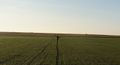
Coordinates reached, yay!
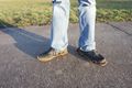
dirty shoes, again...

grin photo
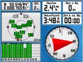
Yep, we did it.


Achievements
Yakamoz and Rincewind earned the Land geohash achievement
|