Difference between revisions of "2014-01-19 43 -121"
imported>Frogman (→Expedition) |
imported>FippeBot m (Location) |
||
| (2 intermediate revisions by one other user not shown) | |||
| Line 47: | Line 47: | ||
--> | --> | ||
<gallery perrow="5"> | <gallery perrow="5"> | ||
| + | Image:2014-01-19 43 -121 restricted.jpg | Some roads were restricted to vehicle! A vandal was unhappy about that fact. | ||
| + | Image:2014-01-19 43 -121 tracks.jpg | What kind of tracks are these? | ||
| + | Image:2014-01-19 43 -121 daisy.jpg | Daisy at the hashpoint. | ||
| + | Image:2014-01-19 43 -121 pictures.jpg | Documenting the day! | ||
| + | Image:2014-01-19 43 -121 grins.jpg | Goofy grins! We had to take the picture quickly because [[User:Benture|Benture]] was holding Daisy, and because of this he was cropped out. | ||
| + | Image:2014-01-19 43 -121 holdingdaisy.jpg | Daisy isn't a huge fan of being held, but it's easier to take pictures of her that way. | ||
| + | Image:2014-01-19 43 -121 hashpoint.jpg | The area around the hashpoint. | ||
| + | Image:2014-01-19 43 -121 fortrock1.jpg | Fort Rock! This picture doesn't really do it justice. | ||
| + | Image:2014-01-19 43 -121 fortrock2.jpg | It's very large and roundish. This is just the part of it near the day use area. | ||
| + | Image:2014-01-19 43 -121 fortrock3.jpg | It's a state monument! | ||
| + | Image:2014-01-19 43 -121 proof.jpg | Proof. | ||
</gallery> | </gallery> | ||
| Line 54: | Line 65: | ||
| − | |||
| − | |||
| − | |||
| − | |||
| − | |||
| − | |||
| − | |||
| − | |||
| − | |||
| − | |||
[[Category:Expeditions]] | [[Category:Expeditions]] | ||
| − | |||
| − | |||
| − | |||
| − | |||
| − | |||
| − | |||
| − | |||
[[Category:Coordinates reached]] | [[Category:Coordinates reached]] | ||
| − | + | {{location|US|OR|LK}} | |
| − | |||
| − | |||
| − | |||
| − | |||
| − | |||
| − | |||
| − | |||
| − | |||
| − | |||
| − | |||
| − | |||
| − | |||
| − | |||
| − | |||
| − | |||
| − | |||
| − | |||
Latest revision as of 05:16, 14 August 2019
| Sun 19 Jan 2014 in 43,-121: 43.4606060, -121.2545269 geohashing.info google osm bing/os kml crox |
Location
In southern Deschutes National Forest, near Hole-In-The-Ground.
Participants
Plans
We wanted to get out of the house but had no specific travel plans. We decided to try for this hash and in the event that weather thwarted us go to Fort Rock State Park instead.
Expedition
The drive down US Numbered Highway 97 onto State Highway 31 was gorgeous. We stopped at an informational kiosk on the way into what signs called "Oregon's Outback" that told us about Fort Rock, Hole-in-the-Ground, and other nearby landmarks.
The drive to the hashpoint was pretty easy, once we figured out where to go. Some signs were posted marking restricted access. However, on closer inspection these signs explained that not all of the roads were closed to vehicle traffic over the winter, just most of them. Luckily, the hashpoint was along one of these open roads, even though it was not the straightest shot to the point. We went up forest road 2424, which was surprisingly easy to drive on for being a 4-digit NF road (although there were some large potholes).
The hashpoint itself was easy to get to; it was about a kilometer walk from where we had to park, and we were able to walk along roads for most of the time. It was flat and vegetation was not so dense that it was difficult to traverse. Daisy had a fun time and we saw a lot of non-human non-dog animal tracks, notably a deer and a rabbit.
After reaching the hashpoint we headed over to Fort Rock. It was rather awe-inspiring so we took a lot of pictures of it. It was getting too late to hike to the top of the rock but we agreed that it would be fun to visit at a later date.
Tracklog
Photos
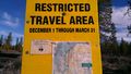
Some roads were restricted to vehicle! A vandal was unhappy about that fact.
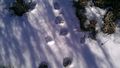
What kind of tracks are these?
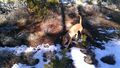
Daisy at the hashpoint.
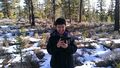
Documenting the day!
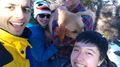
Goofy grins! We had to take the picture quickly because Benture was holding Daisy, and because of this he was cropped out.
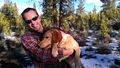
Daisy isn't a huge fan of being held, but it's easier to take pictures of her that way.
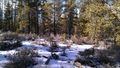
The area around the hashpoint.
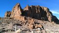
Fort Rock! This picture doesn't really do it justice.
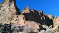
It's very large and roundish. This is just the part of it near the day use area.
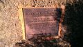
It's a state monument!
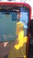
Proof.


