Difference between revisions of "2014-01-20 34 -118"
imported>Bravissimo594 (→Location: Added name of wash.) |
imported>FippeBot m (Location) |
||
| (12 intermediate revisions by one other user not shown) | |||
| Line 25: | Line 25: | ||
--> | --> | ||
* [[User:Bravissimo594|Bravissimo594]] ([[User talk:Bravissimo594|talk]]) | * [[User:Bravissimo594|Bravissimo594]] ([[User talk:Bravissimo594|talk]]) | ||
| − | |||
== Plans == | == Plans == | ||
<!-- what were the original plans --> | <!-- what were the original plans --> | ||
| − | [[User:Boppy5|Boppy5]] and I intend to get to this [[Los_Angeles,_California|Los Angeles]] hash point at 4:00pm. I am not sure what the parking availability is nearby on Railroad Avenue, so there may be a delay related to that. [[User:Bravissimo594|Bravissimo594]] ([[User talk:Bravissimo594|talk]]) | + | :[[User:Boppy5|Boppy5]] and I intend to get to this [[Los_Angeles,_California|Los Angeles]] hash point at 4:00pm on Monday. I am not sure what the parking availability is nearby on Railroad Avenue, so there may be a delay related to that. [[User:Bravissimo594|Bravissimo594]] ([[User talk:Bravissimo594|talk]]) |
| + | ::If parking is not available on Railroad Avenue then we will try to get to the point by parking at the cul-de-sac of Faisan Court, on the west side of the river (and west of large power lines). [[User:Bravissimo594|Bravissimo594]] ([[User talk:Bravissimo594|talk]]) 14:01, 19 January 2014 (EST) | ||
== Expedition == | == Expedition == | ||
<!-- how it all turned out. your narrative goes here. --> | <!-- how it all turned out. your narrative goes here. --> | ||
| + | === [[User:Bravissimo594|Bravissimo594]] === | ||
| + | [[User:Boppy5|Boppy5]] was not feeling well, so I headed out from Pasadena at about 4:30pm en route to Santa Clarita. Parking is not allowed along Railroad Avenue adjacent to the hashpoint, so I continued to drive north to find a cut-across to the west side of the dry river hosting the point. I parked at the dead end of a residential road, hopped over a wall, walked under high-voltage transmission lines, and found a ramp down into the riverbed. It turns out that there is a trailhead just one block south of the street I parked on, so I could have saved a wall-jumping if I had parked over there. | ||
| − | + | Down in the dry riverbed, the sandy gravel made the trip a little harder than walking on pavement, but there were no significant obstacles to reaching the hashpoint. I took a couple of photos, leaving room for where [[User:Boppy5|Boppy5]] would have stood, and then returned home. | |
| − | |||
== Photos == | == Photos == | ||
| Line 42: | Line 43: | ||
--> | --> | ||
<gallery perrow="5"> | <gallery perrow="5"> | ||
| + | |||
| + | Image:2014-01-20_34_-118_17-24-50-491.jpg | Made it! [http://www.openstreetmap.org/?lat=34.40149301&lon=-118.53950382&zoom=16&layers=B000FTF @34.4015,-118.5395] | ||
| + | |||
| + | Image:2014-01-20_34_-118_17-25-38-320.jpg | Leaving space for Boppy5. [http://www.openstreetmap.org/?lat=34.40150000&lon=-118.54000000&zoom=16&layers=B000FTF @34.4015,-118.5400] | ||
</gallery> | </gallery> | ||
| Line 53: | Line 58: | ||
<!-- Potential categories. Please include all the ones appropriate to your expedition --> | <!-- Potential categories. Please include all the ones appropriate to your expedition --> | ||
| − | <!-- If this is a planning page: | + | <!-- If this is a planning page: |
[[Category:Expedition planning]] | [[Category:Expedition planning]] | ||
| + | --> | ||
| − | + | <!-- An actual expedition: --> | |
| − | <!-- An actual expedition: | ||
[[Category:Expeditions]] | [[Category:Expeditions]] | ||
| − | |||
[[Category:Expeditions with photos]] | [[Category:Expeditions with photos]] | ||
| − | [[Category:Expeditions with videos]] | + | <!-- [[Category:Expeditions with videos]] |
[[Category:Expedition without GPS]] | [[Category:Expedition without GPS]] | ||
--> | --> | ||
| − | <!-- if you reached your coords: | + | <!-- if you reached your coords: --> |
[[Category:Coordinates reached]] | [[Category:Coordinates reached]] | ||
| − | + | <!-- or if you failed :( | |
| − | |||
[[Category:Coordinates not reached]] | [[Category:Coordinates not reached]] | ||
-- and a reason -- | -- and a reason -- | ||
| Line 85: | Line 88: | ||
(Don't forget to delete this final close comment marker) --> | (Don't forget to delete this final close comment marker) --> | ||
| + | {{location|US|CA|LO}} | ||
Latest revision as of 05:17, 14 August 2019
| Mon 20 Jan 2014 in 34,-118: 34.4015294, -118.5395423 geohashing.info google osm bing/os kml crox |
Location
In the dry South Fork River (wash) off of Railroad Ave. in Santa Clarita.
Participants
Plans
- Boppy5 and I intend to get to this Los Angeles hash point at 4:00pm on Monday. I am not sure what the parking availability is nearby on Railroad Avenue, so there may be a delay related to that. Bravissimo594 (talk)
- If parking is not available on Railroad Avenue then we will try to get to the point by parking at the cul-de-sac of Faisan Court, on the west side of the river (and west of large power lines). Bravissimo594 (talk) 14:01, 19 January 2014 (EST)
Expedition
Bravissimo594
Boppy5 was not feeling well, so I headed out from Pasadena at about 4:30pm en route to Santa Clarita. Parking is not allowed along Railroad Avenue adjacent to the hashpoint, so I continued to drive north to find a cut-across to the west side of the dry river hosting the point. I parked at the dead end of a residential road, hopped over a wall, walked under high-voltage transmission lines, and found a ramp down into the riverbed. It turns out that there is a trailhead just one block south of the street I parked on, so I could have saved a wall-jumping if I had parked over there.
Down in the dry riverbed, the sandy gravel made the trip a little harder than walking on pavement, but there were no significant obstacles to reaching the hashpoint. I took a couple of photos, leaving room for where Boppy5 would have stood, and then returned home.
Photos
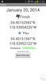
Made it! @34.4015,-118.5395
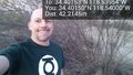
Leaving space for Boppy5. @34.4015,-118.5400

