Difference between revisions of "2014-01-25 43 -116"
imported>Eldin (An expedition message sent via Geohash Droid for Android.) |
imported>FippeBot m (Location) |
||
| (5 intermediate revisions by 2 users not shown) | |||
| Line 1: | Line 1: | ||
| − | |||
| − | |||
| − | |||
| − | |||
| − | |||
| − | |||
| − | |||
| − | |||
| − | |||
| − | |||
{{meetup graticule | {{meetup graticule | ||
| lat=43 | | lat=43 | ||
| Line 15: | Line 5: | ||
}} | }} | ||
| − | |||
__NOTOC__ | __NOTOC__ | ||
== Location == | == Location == | ||
| − | + | Todays hashpoint is at the Eagle Sports Complex. | |
== Participants == | == Participants == | ||
| − | + | * [[User:Ojones|Ojones]] | |
| − | + | * [[User:Eldin|Eldin]] | |
| − | == | + | == Expedition == |
| − | + | '''Ojones''' The geohash looked to be easily accessible according to online maps. Drove out to the hashpoint and parked at the sports complex. I arrived at about 5pm. It was a short walk from the parking lot to the hashpoint. I took a few pictures and returned home. | |
| − | + | '''Eldin''' The geohash looked to be accessible, and I was out in the area anyway. So I decided to try for it. The hashpoint was easy to reach, along some trails just outside the sports park. I reached it at just after 1pm, took some pictures, then headed back. | |
| − | |||
| − | == | + | *At the hashpoint. Pics and writeup to follow. -- [[User:Eldin|Eldin]] ([[User talk:Eldin|talk]]) [http://www.openstreetmap.org/?lat=43.71371105&lon=-116.31370535&zoom=16&layers=B000FTF @43.7137,-116.3137] 13:12, 25 January 2014 (MST) |
| − | |||
== Photos == | == Photos == | ||
| − | < | + | '''OJones:''' |
| − | Image: | + | <gallery> |
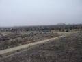
| − | --> | + | Image:2014-01-25 43 -116 view.jpg | View of Eagle Sports Complex from hashpoint |
| − | <gallery | + | Image:2014-01-25 43 -116 grinning.jpg | Grinning Geohasher |
| + | Image:2014-01-25 43 -116 hashpoint.jpg | Hashpoint | ||
| + | </gallery> | ||
| + | '''Eldin:''' | ||
| + | <gallery> | ||
| + | File:2014-01-25 43 -116 grin.jpg | Grin. | ||
| + | File:2014-01-25 43 -116 proof.jpg | Proof of reaching coordinates. | ||
| + | File:2014-01-25 43 -116 view2.jpg | Looking back towards the park. | ||
| + | File:2014-01-25 43 -116 marker.jpg | Crude marker made of sticks, left at the hashpoint. | ||
</gallery> | </gallery> | ||
| − | |||
== Achievements == | == Achievements == | ||
{{#vardefine:ribbonwidth|800px}} | {{#vardefine:ribbonwidth|800px}} | ||
| − | |||
| − | |||
| − | |||
| − | |||
| − | |||
| − | |||
| − | |||
| − | |||
| − | |||
| − | |||
| − | |||
| − | |||
[[Category:Expeditions]] | [[Category:Expeditions]] | ||
| − | |||
[[Category:Expeditions with photos]] | [[Category:Expeditions with photos]] | ||
| − | |||
| − | |||
| − | |||
| − | |||
| − | |||
[[Category:Coordinates reached]] | [[Category:Coordinates reached]] | ||
| − | + | {{location|US|ID|AA}} | |
| − | |||
| − | |||
| − | |||
| − | |||
| − | |||
| − | |||
| − | |||
| − | |||
| − | |||
| − | |||
| − | |||
| − | |||
| − | |||
| − | |||
| − | |||
| − | |||
| − | |||
Latest revision as of 05:21, 14 August 2019
| Sat 25 Jan 2014 in 43,-116: 43.7137096, -116.3137196 geohashing.info google osm bing/os kml crox |
Location
Todays hashpoint is at the Eagle Sports Complex.
Participants
Expedition
Ojones The geohash looked to be easily accessible according to online maps. Drove out to the hashpoint and parked at the sports complex. I arrived at about 5pm. It was a short walk from the parking lot to the hashpoint. I took a few pictures and returned home.
Eldin The geohash looked to be accessible, and I was out in the area anyway. So I decided to try for it. The hashpoint was easy to reach, along some trails just outside the sports park. I reached it at just after 1pm, took some pictures, then headed back.
- At the hashpoint. Pics and writeup to follow. -- Eldin (talk) @43.7137,-116.3137 13:12, 25 January 2014 (MST)
Photos
OJones:
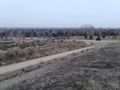
View of Eagle Sports Complex from hashpoint
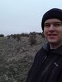
Grinning Geohasher
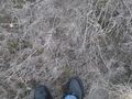
Hashpoint


Eldin:

Grin.
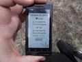
Proof of reaching coordinates.
Looking back towards the park.
Crude marker made of sticks, left at the hashpoint.


