Difference between revisions of "2014-01-28 49 9"
imported>TroLLorT (Created page with "{{subst:Expedition |lat = 49 |lon = 9 |date = 2014-01-28 }}") |
imported>FippeBot m (Location) |
||
| (5 intermediate revisions by one other user not shown) | |||
| Line 1: | Line 1: | ||
| − | |||
| − | |||
| − | |||
| − | |||
| − | |||
| − | |||
| − | |||
| − | |||
| − | |||
| − | |||
{{meetup graticule | {{meetup graticule | ||
| lat=49 | | lat=49 | ||
| lon=9 | | lon=9 | ||
| date=2014-01-28 | | date=2014-01-28 | ||
| + | | graticule_name=Würzburg (49 9) | ||
| + | | graticule_link=Würzburg, Germany | ||
}} | }} | ||
| − | |||
| − | |||
__NOTOC__ | __NOTOC__ | ||
== Location == | == Location == | ||
| − | + | Today's location is a 3-way junction of the ''Raiffeisenstraße'' in [[wikipedia:de:Klingenberg_(Heilbronn)|Klingenberg]], a borough of Heilbronn. | |
| + | * District: Heilbronn | ||
| + | * Administrative region: Stuttgart | ||
| + | * State: Baden-Württemberg (EU:DE:BW) | ||
| + | * Country: Germany | ||
== Participants == | == Participants == | ||
| − | + | * [[User:TroLLorT|TroLLorT]] ([[User talk:TroLLorT|talk]]) on his first expedition | |
| − | |||
== Plans == | == Plans == | ||
| − | + | It's just the next village from my home cave's village. Really easy. Will walk or cycle there. Planned time of arrival is 15:00 CET. | |
== Expedition == | == Expedition == | ||
| − | < | + | I creeped out of my cave and called together the trolls at 13:45. The sun was shining from a blue sky, covered just with some fleecy clouds - nobody would suspect <s>the Spanish Inquisition</s> a troll attack in this beautiful weather. So we marched out of the village, over the Ship Canal's bridge past the lock and the hydroelectric power station. On the way to Klingenberg we met a lot of dogs, but those were too cowed by our frightening presence for patting. After rushing through the open town gates we stormed the castle hill to reach finally the hashpoint. While I decorated a post with a Geotag, the other trolls faned out to find something loot-worthy. But.. some creatures must have gotten there first: The streets were deserted (apart from a few weapons lying around), all houses barricaded and the castle in ruins. Additionally no allies showed up. So we were forced to return home - victorious but with poor haul. |
== Tracklog == | == Tracklog == | ||
| − | + | ''No GPS - no log.'' | |
== Photos == | == Photos == | ||
| − | |||
| − | |||
| − | |||
<gallery perrow="5"> | <gallery perrow="5"> | ||
| + | Image:2014-01-28 49 9 data.JPG | For the record.. | ||
| + | Image:2014-01-28 49 9 outward.JPG | <nowiki>*epic bass riff starts*</nowiki><br/>''She <s>came to</s> fled from me one morning, one lonely <s>Sunday</s> Tuesday morning...'' | ||
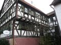
| + | Image:2014-01-28 49 9 nice house.JPG | Nice ol' house #1 | ||
| + | Image:2014-01-28 49 9 bridge.JPG | The first bridge to cross. | ||
| + | Image:2014-01-28 49 9 canal.JPG | Bottom-up: Neckar canal, Heilbronn (partly), puffy clouds. | ||
| + | Image:2014-01-28 49 9 hps.JPG | "4.3 megawatts?!<br/>4.3 megawatts?!?<br/>Great Scott!" | ||
| + | Image:2014-01-28 49 9 klingenberg.JPG | Attack plan: Over the second bridge (left), through Old Klingenberg (right) and upon that hill. | ||
| + | Image:2014-01-28 49 9 castle.JPG | Detailed view of the castle (or manor.. or estate.. or its leftovers). | ||
| + | Image:2014-01-28 49 9 sheeps.JPG | Wooly snacks on legs! | ||
| + | Image:2014-01-28 49 9 neckar.JPG | The original Neckar. | ||
| + | Image:2014-01-28 49 9 ducks.JPG | "Hellouuu sweet ladi-"<br/>"STOP STARING ON MY TAIL, YOU HORNY LITTLE DRAKE!" | ||
| + | Image:2014-01-28 49 9 warning.JPG | Neckar Car Wash: Park here & find your perfectly cleaned car downriver a few hours later! For free! | ||
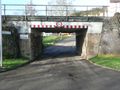
| + | Image:2014-01-28 49 9 gate.JPG | Da mighty town gates.<br/><small>Just kidding, it's a railway underpass.</small> | ||
| + | Image:2014-01-28 49 9 church.JPG | Da not so mighty church. | ||
| + | Image:2014-01-28 49 9 house.JPG | Nice ol' house #2 | ||
| + | Image:2014-01-28 49 9 crossroads.JPG | Somewhere in the middle: Da Hashpoint! | ||
| + | Image:2014-01-28 49 9 tag.JPG | Da Geotag. | ||
| + | Image:2014-01-28 49 9 post.JPG | Da post with da Geotag (in red circle). | ||
| + | Image:2014-01-28 49 9 spoon.JPG | A weapon so deadly sharp no blood can stick to it.. | ||
| + | Image:2014-01-28 49 9 ruin.JPG | ..and signs of former attacks. | ||
</gallery> | </gallery> | ||
== Achievements == | == Achievements == | ||
{{#vardefine:ribbonwidth|800px}} | {{#vardefine:ribbonwidth|800px}} | ||
| − | + | {{land geohash | |
| + | | latitude = 49 | ||
| + | | longitude = 9 | ||
| + | | date = 2014-01-28 | ||
| + | | name = [[User:TroLLorT|TroLLorT]] | ||
| + | }} | ||
| + | {{Walk geohash | ||
| + | | latitude = 49 | ||
| + | | longitude = 9 | ||
| + | | date = 2014-01-28 | ||
| + | | name = [[User:TroLLorT|TroLLorT]] | ||
| + | | distance = 4.2 km (there and back) | ||
| + | }} | ||
| + | {{No_batteries_geohash | ||
| + | | latitude = 49 | ||
| + | | longitude = 9 | ||
| + | | date = 2014-01-28 | ||
| + | | name = [[User:TroLLorT|TroLLorT]] | ||
| + | }} | ||
| − | |||
| − | |||
| − | |||
| − | |||
| − | |||
| − | |||
| − | |||
| − | |||
| − | |||
| − | |||
| − | |||
[[Category:Expeditions]] | [[Category:Expeditions]] | ||
| − | |||
[[Category:Expeditions with photos]] | [[Category:Expeditions with photos]] | ||
| − | |||
[[Category:Expedition without GPS]] | [[Category:Expedition without GPS]] | ||
| − | + | ||
| − | |||
| − | |||
[[Category:Coordinates reached]] | [[Category:Coordinates reached]] | ||
| − | + | {{location|DE|BW|HN|city=true}} | |
| − | |||
| − | |||
| − | |||
| − | |||
| − | |||
| − | |||
| − | |||
| − | |||
| − | |||
| − | |||
| − | |||
| − | |||
| − | |||
| − | |||
| − | |||
| − | |||
| − | |||
Latest revision as of 06:58, 6 August 2019
| Tue 28 Jan 2014 in Würzburg (49 9): 49.1188622, 9.1543423 geohashing.info google osm bing/os kml crox |
Location
Today's location is a 3-way junction of the Raiffeisenstraße in Klingenberg, a borough of Heilbronn.
- District: Heilbronn
- Administrative region: Stuttgart
- State: Baden-Württemberg (EU:DE:BW)
- Country: Germany
Participants
Plans
It's just the next village from my home cave's village. Really easy. Will walk or cycle there. Planned time of arrival is 15:00 CET.
Expedition
I creeped out of my cave and called together the trolls at 13:45. The sun was shining from a blue sky, covered just with some fleecy clouds - nobody would suspect the Spanish Inquisition a troll attack in this beautiful weather. So we marched out of the village, over the Ship Canal's bridge past the lock and the hydroelectric power station. On the way to Klingenberg we met a lot of dogs, but those were too cowed by our frightening presence for patting. After rushing through the open town gates we stormed the castle hill to reach finally the hashpoint. While I decorated a post with a Geotag, the other trolls faned out to find something loot-worthy. But.. some creatures must have gotten there first: The streets were deserted (apart from a few weapons lying around), all houses barricaded and the castle in ruins. Additionally no allies showed up. So we were forced to return home - victorious but with poor haul.
Tracklog
No GPS - no log.
Photos
For the record..
*epic bass riff starts*
Shecame tofled from me one morning, one lonelySundayTuesday morning...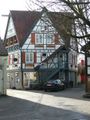
Nice ol' house #1
The first bridge to cross.
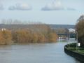
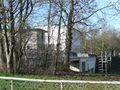
Bottom-up: Neckar canal, Heilbronn (partly), puffy clouds.
"4.3 megawatts?!
4.3 megawatts?!?
Great Scott!"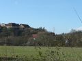
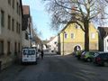
Attack plan: Over the second bridge (left), through Old Klingenberg (right) and upon that hill.
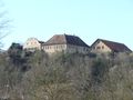
Detailed view of the castle (or manor.. or estate.. or its leftovers).
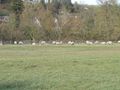
Wooly snacks on legs!
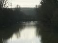
The original Neckar.
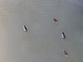
"Hellouuu sweet ladi-"
"STOP STARING ON MY TAIL, YOU HORNY LITTLE DRAKE!"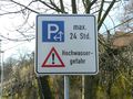
Neckar Car Wash: Park here & find your perfectly cleaned car downriver a few hours later! For free!
Da mighty town gates.
Just kidding, it's a railway underpass.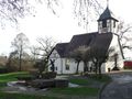
Da not so mighty church.
Nice ol' house #2
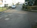
Somewhere in the middle: Da Hashpoint!
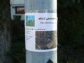
Da Geotag.
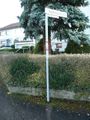
Da post with da Geotag (in red circle).
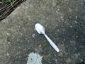
A weapon so deadly sharp no blood can stick to it..

..and signs of former attacks.


Achievements
TroLLorT earned the Land geohash achievement
|
TroLLorT earned the Walk geohash Achievement
|
TroLLorT earned the No Batteries Geohash Achievement
|