Difference between revisions of "2014-01-31 37 -121"
imported>Codae (Created page with "{{subst:Expedition |lat = 37 |lon = -121 |date = 2014-01-31 }}") |
imported>FippeBot m (Location) |
||
| (4 intermediate revisions by one other user not shown) | |||
| Line 18: | Line 18: | ||
__NOTOC__ | __NOTOC__ | ||
== Location == | == Location == | ||
| − | + | In a condominium complex (is there a better word for that?) in San Jose, California. | |
== Participants == | == Participants == | ||
| − | + | [[User:Codae|Codae]] | |
| − | |||
== Plans == | == Plans == | ||
| − | + | I didn't have a lot of downtime during the day, so all I knew when I set out was that | |
| + | * the geohash was on a plot of land behind a shopping center, and | ||
| + | * there was a bus line nearby. | ||
| + | |||
| + | If I had given Google Earth more time to load, I probably could have recognized the plot as residential, but this was clearly the easiest geohash in my area this weekend, so once I had free time (around 4 PM) I downloaded sufficient maps to make it clear what bus lines were appropriate and headed to BART (Bay Area Rapid Transit, a network of electric trains). | ||
== Expedition == | == Expedition == | ||
| − | + | I took BART as far as Fremont, getting there after sundown. There I got on a (Santa Clara) Valley Transportation Authority bus. Thanks to a dearth of small bills to pay fares, I bought a day pass; however, this was an express bus, and therefore required an additional $2. I could not have paid this myself except with a fiver, but luckily the girl behind me getting on the bus supplied me with the necessary cash. | |
| + | |||
| + | The bus line running by the geohash was one transfer away from there. The road by which it traveled, however, was the Almaden Expressway, and I was skeptical of frequent stops along it. I decided to err on the side of caution and submitted a stop request as soon as the bus got on the expressway. This was, in fact, an error, and later review confirmed that I could have saved myself the better part of a mile's walk if I had known just how frequent the bus pullovers were on that road. | ||
| + | |||
| + | I walked to the shopping center and discovered that it was cut off from the plot containing the geohash by a wall without a nearby break. So I set out around the enclosure in a counterclockwise direction, seeking the entrance. Abutting the wall was a fenced-off section of the parking lot, containing a decrepit former Orchard Supply Hardware building. An advertisement for one final sale was scrawled on its windows. | ||
| + | |||
| + | More helpful to me was the notice of redevelopment mounted on the fence, which (as I read it at the time) indicated that the plot of interest was traversed by a road called "Gables Drive". I took this indication of residentiality as a good sign, since it meant the geohash probably wasn't closed off for the night. | ||
| + | |||
| + | The road was actually called "Cedar Gables Drive". I was unchallenged as I made my way to the back of the subdivision and did the GPS dance on a section of road that led only to a fire exit. I took a few pictures and left. | ||
| + | |||
| + | I did not return the way I had come, since I didn't want to have to deal with the express line again. Instead, I continued along the local bus line to its southern terminus, at a spur of the VTA's light rail system. Appropriately for Silicon Valley, the station (as well as the trains) was equipped with free wi-fi, which I used to write the beginning of this wiki page. | ||
| + | |||
| + | I transferred from the light rail to an AC Transit bus, taking advantage of a long-term pass I already had to get a free ride despite its recent expiration. This took me to Fremont BART, and I returned home that way. | ||
== Tracklog == | == Tracklog == | ||
| Line 38: | Line 53: | ||
--> | --> | ||
<gallery perrow="5"> | <gallery perrow="5"> | ||
| + | Image:2014-01-31 37 -121 OSH.JPG | A sad, decaying hardware store. | ||
| + | Image:2014-01-31 37 -121 Notice.JPG | A useful map. | ||
| + | Image:2014-01-31 37 -121 Proof.JPG | I actually found photography easier at night than during the day. | ||
| + | Image:2014-01-31 37 -121 Hashpoint.JPG | The hashpoint itself. | ||
</gallery> | </gallery> | ||
| Line 43: | Line 62: | ||
{{#vardefine:ribbonwidth|800px}} | {{#vardefine:ribbonwidth|800px}} | ||
<!-- Add any achievement ribbons you earned below, or remove this section --> | <!-- Add any achievement ribbons you earned below, or remove this section --> | ||
| + | {{Land geohash | latitude = 37 | longitude = -121 | date = 2014-01-31 | name = Codae}} | ||
| + | {{Public transport geohash | latitude = 37 | longitude = -121 | date = 2014-01-31 | name = Codae}} | ||
| + | {{Minesweeper geohash | graticule = San Jose, California | ranknumber = 2 | w = true | nw = true | name = Codae}} | ||
<!-- =============== USEFUL CATEGORIES FOLLOW ================ | <!-- =============== USEFUL CATEGORIES FOLLOW ================ | ||
Delete the next line ONLY if you have chosen the appropriate categories below. If you are unsure, don't worry. People will read your report and help you with the classification. --> | Delete the next line ONLY if you have chosen the appropriate categories below. If you are unsure, don't worry. People will read your report and help you with the classification. --> | ||
| − | |||
| − | |||
| − | |||
| − | |||
| − | |||
| − | + | ||
[[Category:Expeditions]] | [[Category:Expeditions]] | ||
| − | + | ||
[[Category:Expeditions with photos]] | [[Category:Expeditions with photos]] | ||
| − | + | ||
| − | + | ||
| − | |||
| − | |||
| − | |||
[[Category:Coordinates reached]] | [[Category:Coordinates reached]] | ||
| − | + | {{location|US|CA|SL}} | |
| − | |||
| − | |||
| − | |||
| − | |||
| − | |||
| − | |||
| − | |||
| − | |||
| − | |||
| − | |||
| − | |||
| − | |||
| − | |||
| − | |||
| − | |||
| − | |||
| − | |||
Latest revision as of 05:23, 14 August 2019
| Fri 31 Jan 2014 in 37,-121: 37.2616607, -121.8769173 geohashing.info google osm bing/os kml crox |
Location
In a condominium complex (is there a better word for that?) in San Jose, California.
Participants
Plans
I didn't have a lot of downtime during the day, so all I knew when I set out was that
* the geohash was on a plot of land behind a shopping center, and
* there was a bus line nearby.
If I had given Google Earth more time to load, I probably could have recognized the plot as residential, but this was clearly the easiest geohash in my area this weekend, so once I had free time (around 4 PM) I downloaded sufficient maps to make it clear what bus lines were appropriate and headed to BART (Bay Area Rapid Transit, a network of electric trains).
Expedition
I took BART as far as Fremont, getting there after sundown. There I got on a (Santa Clara) Valley Transportation Authority bus. Thanks to a dearth of small bills to pay fares, I bought a day pass; however, this was an express bus, and therefore required an additional $2. I could not have paid this myself except with a fiver, but luckily the girl behind me getting on the bus supplied me with the necessary cash.
The bus line running by the geohash was one transfer away from there. The road by which it traveled, however, was the Almaden Expressway, and I was skeptical of frequent stops along it. I decided to err on the side of caution and submitted a stop request as soon as the bus got on the expressway. This was, in fact, an error, and later review confirmed that I could have saved myself the better part of a mile's walk if I had known just how frequent the bus pullovers were on that road.
I walked to the shopping center and discovered that it was cut off from the plot containing the geohash by a wall without a nearby break. So I set out around the enclosure in a counterclockwise direction, seeking the entrance. Abutting the wall was a fenced-off section of the parking lot, containing a decrepit former Orchard Supply Hardware building. An advertisement for one final sale was scrawled on its windows.
More helpful to me was the notice of redevelopment mounted on the fence, which (as I read it at the time) indicated that the plot of interest was traversed by a road called "Gables Drive". I took this indication of residentiality as a good sign, since it meant the geohash probably wasn't closed off for the night.
The road was actually called "Cedar Gables Drive". I was unchallenged as I made my way to the back of the subdivision and did the GPS dance on a section of road that led only to a fire exit. I took a few pictures and left.
I did not return the way I had come, since I didn't want to have to deal with the express line again. Instead, I continued along the local bus line to its southern terminus, at a spur of the VTA's light rail system. Appropriately for Silicon Valley, the station (as well as the trains) was equipped with free wi-fi, which I used to write the beginning of this wiki page.
I transferred from the light rail to an AC Transit bus, taking advantage of a long-term pass I already had to get a free ride despite its recent expiration. This took me to Fremont BART, and I returned home that way.
Tracklog
Photos
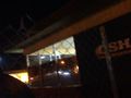
A sad, decaying hardware store.
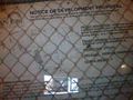
A useful map.
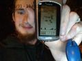
I actually found photography easier at night than during the day.
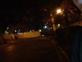
The hashpoint itself.


Achievements
Codae earned the Land geohash achievement
|
Codae earned the Public transport geohash achievement
|
Codae achieved level 2 of the Minesweeper Geohash achievement
|