Difference between revisions of "2014-02-02 34 -118"
imported>Bravissimo594 (Changed category to "Expedition planning") |
imported>FippeBot m (Location) |
||
| (8 intermediate revisions by one other user not shown) | |||
| Line 1: | Line 1: | ||
| − | <!-- If you did not specify these parameters in the template, please substitute appropriate values for IMAGE, LAT, LON, and DATE (YYYY-MM-DD format) | + | <!-- If you did not specify these parameters in the template, please substitute appropriate values for IMAGE, LAT, LON, and DATE (YYYY-MM-DD format) --> |
| − | [[Image:{{{image| | + | [[Image:{{{image|2014-02-02_34_-118_10-40-59-178.jpg}}}|thumb|left]] |
| − | Remove this section if you don't want an image at the top (left) of your report. You should remove the "Image:" or "File:" | + | <!-- Remove this section if you don't want an image at the top (left) of your report. You should remove the "Image:" or "File:" |
tag from your image file name, and replace the all upper-case word IMAGE in the above line. | tag from your image file name, and replace the all upper-case word IMAGE in the above line. | ||
| Line 19: | Line 19: | ||
== Location == | == Location == | ||
<!-- where you've surveyed the hash to be --> | <!-- where you've surveyed the hash to be --> | ||
| − | In the Mojave Desert, northeast of Lancaster. | + | In the Mojave Desert, northeast of Lancaster. [[Los_Angeles,_California|Los Angeles]] graticule. |
== Participants == | == Participants == | ||
| Line 32: | Line 32: | ||
== Expedition == | == Expedition == | ||
<!-- how it all turned out. your narrative goes here. --> | <!-- how it all turned out. your narrative goes here. --> | ||
| + | === [[User:Bravissimo594|Bravissimo594]] === | ||
| + | I left the San Gabriel Valley at about 8:30am local time, with a stop in La Cañada to get a flowering plant to pass along to the patient in Tehachapi. The two puppies on board, knowing we were in the desert as soon as we passed northeast of the San Andreas Fault, started to sniff the air vents. I decided to fuel up at the Costco in Lancaster even though I knew it would keep me from making my proposed 10:00am meetup on time. | ||
| − | + | With a full tank, I left Lancaster at about 10:00am and continued north on State Route 14, exited at Avenue F, and then alternated between eastbound and northbound streets. The almost-sad moment came when driving eastward along East Avenue E: knowing that I would have to drive almost one more mile north, I noticed that the land just north of Avenue E was blocked off by a barbed wire fence and signs reading "US Air Force Installation." Not wanting to incur wrath of Edward's Air Force Base's military police, there was no way I would cross through that fence for a meetup. Fortunately, at about 40th Street East, the fence turned north ... as I also did at the [http://goo.gl/maps/v5ZYN unpaved 45th Street East]. I got as far north as the unpaved Avenue D (which was north enough for the hash point) before the barbed wire turned east. Just a few hundred meters east from there, I stopped the car and headed south to the hash point, reaching it successfully. | |
| − | + | ||
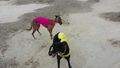
| + | The ground was too hard and uneven for me to let the dogs run too much there, so after reaching the hash point, we went to another spot with softer ground. They got to play with one friendly jack (who will be available to play again another day), and we then continued north to visit the patient. After an hour or so visiting, we returned to the San Gabriel Valley just in time to see how badly the Seahawks were beating up on the Broncos. | ||
== Photos == | == Photos == | ||
| Line 41: | Line 44: | ||
--> | --> | ||
<gallery perrow="5"> | <gallery perrow="5"> | ||
| + | |||
| + | Image:2014-02-02_34_-118_10-37-33-900.jpg | The spot ... just like all the others around here. [http://www.openstreetmap.org/?lat=34.77670000&lon=-118.04800000&zoom=16&layers=B000FTF @34.7767,-118.0480] | ||
| + | |||
| + | Image:2014-02-02_34_-118_10-40-19-888.jpg | Success! | ||
| + | |||
| + | Image:2014-02-02_34_-118_10-40-59-178.jpg | No friends to play with. :-( [http://www.openstreetmap.org/?lat=34.77670000&lon=-118.04800000&zoom=16&layers=B000FTF @34.7767,-118.0480] | ||
| + | |||
| + | Image:2014-02-02_34_-118_10-43-55-556.jpg | Hash point is 100 meters on the "good side" of this barbed wire fence belonging, I believe, to Edwards Air Force Base. [http://www.openstreetmap.org/?lat=34.77770000&lon=-118.04800000&zoom=16&layers=B000FTF @34.7777,-118.0480] | ||
</gallery> | </gallery> | ||
| Line 51: | Line 62: | ||
<!-- Potential categories. Please include all the ones appropriate to your expedition --> | <!-- Potential categories. Please include all the ones appropriate to your expedition --> | ||
| − | <!-- If this is a planning page: | + | <!-- If this is a planning page: |
| − | [[Category:Expedition planning]] | + | [[Category:Expedition planning]] --> |
| − | <!-- An actual expedition: | + | <!-- An actual expedition: --> |
[[Category:Expeditions]] | [[Category:Expeditions]] | ||
| − | |||
[[Category:Expeditions with photos]] | [[Category:Expeditions with photos]] | ||
| − | |||
| − | |||
| − | |||
| − | <!-- if you reached your coords: | + | <!-- if you reached your coords: --> |
[[Category:Coordinates reached]] | [[Category:Coordinates reached]] | ||
| − | + | <!-- or if you failed :( | |
[[Category:Coordinates not reached]] | [[Category:Coordinates not reached]] | ||
-- and a reason -- | -- and a reason -- | ||
| Line 83: | Line 90: | ||
(Don't forget to delete this final close comment marker) --> | (Don't forget to delete this final close comment marker) --> | ||
| + | {{location|US|CA|LO}} | ||
Latest revision as of 05:24, 14 August 2019

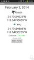
| Sun 2 Feb 2014 in 34,-118: 34.7766962, -118.0479506 geohashing.info google osm bing/os kml crox |
Location
In the Mojave Desert, northeast of Lancaster. Los Angeles graticule.
Participants
Plans
I will drive by and let a couple of puppies stretch their legs out on the way to visit a friend in Tehachapi. Maybe there will be fauna to play with. I currently plan to be at the hashpoint at 10:00am on Sunday. Bravissimo594 (talk) 18:41, 1 February 2014 (EST)
Expedition
Bravissimo594
I left the San Gabriel Valley at about 8:30am local time, with a stop in La Cañada to get a flowering plant to pass along to the patient in Tehachapi. The two puppies on board, knowing we were in the desert as soon as we passed northeast of the San Andreas Fault, started to sniff the air vents. I decided to fuel up at the Costco in Lancaster even though I knew it would keep me from making my proposed 10:00am meetup on time.
With a full tank, I left Lancaster at about 10:00am and continued north on State Route 14, exited at Avenue F, and then alternated between eastbound and northbound streets. The almost-sad moment came when driving eastward along East Avenue E: knowing that I would have to drive almost one more mile north, I noticed that the land just north of Avenue E was blocked off by a barbed wire fence and signs reading "US Air Force Installation." Not wanting to incur wrath of Edward's Air Force Base's military police, there was no way I would cross through that fence for a meetup. Fortunately, at about 40th Street East, the fence turned north ... as I also did at the unpaved 45th Street East. I got as far north as the unpaved Avenue D (which was north enough for the hash point) before the barbed wire turned east. Just a few hundred meters east from there, I stopped the car and headed south to the hash point, reaching it successfully.
The ground was too hard and uneven for me to let the dogs run too much there, so after reaching the hash point, we went to another spot with softer ground. They got to play with one friendly jack (who will be available to play again another day), and we then continued north to visit the patient. After an hour or so visiting, we returned to the San Gabriel Valley just in time to see how badly the Seahawks were beating up on the Broncos.
Photos
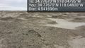
The spot ... just like all the others around here. @34.7767,-118.0480
Success!
No friends to play with. :-( @34.7767,-118.0480
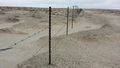
Hash point is 100 meters on the "good side" of this barbed wire fence belonging, I believe, to Edwards Air Force Base. @34.7777,-118.0480


