Difference between revisions of "2014-02-06 50 8"
imported>Rincewind (→Photos) |
imported>FippeBot m (Location) |
||
| Line 36: | Line 36: | ||
[[Category:Expeditions with videos]] | [[Category:Expeditions with videos]] | ||
[[Category:Coordinates reached]] | [[Category:Coordinates reached]] | ||
| + | {{location|DE|HE|F}} | ||
Latest revision as of 05:26, 14 August 2019
| Thu 6 Feb 2014 in 50,8: 50.0709214, 8.6714825 geohashing.info google osm bing/os kml crox |
Location
In the forest betweeen Frankfurt and Neu-Isenburg, just next to the road.
Participants
Plans
The coordinates were quite close to my way home and next to a road in the forest, so I considered this one to be easily accessible.
Expedition
I followed the street leading to Neu-Isenburg, managed to turn a couple of meters into a forest path without being hit by the dense traffic and parked. The hash was a mere 30m away, but then I noticed that the area concealing the hash was fenced in, forest or not. Hmmm, this was gonna be a close one. I guessed it would be a couple of meters behind the fence... Keeping my eyes on the satnav, I hoped and walked towards the coordinates meter for meter, arriving at the fence with 2m to spare. Doing a little hashdance, it was 1m to the right and I thought I might reach the coordinates with my arm over the fence, but then it said 2m backwards, and ta-daa, there I was with my 0m shot. All in all, the expedition just took a 20min detour (mostly because of the traffic lights) and 10mins to change shoes and go hashing. ;)
Photos
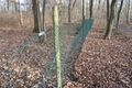
The spot of the geohash coordinates. Note trespassing animal tracks at the fence.
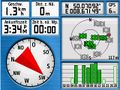
Satnav screenshots

Non-grinning selfie while trying to pull out of the forest path without getting hit by heavy traffic


Achievements
Well, Land. Not worth all the editing trouble. :P