Difference between revisions of "2014-02-13 50 8"
imported>Rincewind (New expedition page) |
imported>Rincewind |
||
| Line 24: | Line 24: | ||
== Photos == | == Photos == | ||
<gallery perrow="5"> | <gallery perrow="5"> | ||
| − | Image:2014-02- | + | Image:2014-02-13_50_8_hashproof.jpg | Hashproof |
| + | Image:2014-02-13_50_8_hashgrin.jpg | Not quite a grin. | ||
</gallery> | </gallery> | ||
Revision as of 19:02, 16 February 2014
| Thu 13 Feb 2014 in 50,8: 50.0436374, 8.6720259 geohashing.info google osm bing/os kml crox |
Location
In the forest of Neu-Isenburg, just next to the forest road.
Participants
Plans
The coordinates were reasonably close to my way home and next to a road in the forest, so I considered this one to be easily accessible after Yakomoz told me about it.
Expedition
Since I know the street where the forest road ends, I drove there and went looking for a parking spot. Bummer. Neu Isenburgs businesses seem to thrive. Back on the main road there was a spot some 50m on. So I just had to walk some 400 meters- not a problem, but the weather was really unpleasant. It was constantly raining and, while not at all cold, damp and felt chilly due to the wetness. When nearing the coordinates, I met a solitary stroller in the rain after my first attempt into the forest. The second attempt to break through the wet underbrush was more successful. While for a split second I had "0m" for three or four times, I had some trouble getting a screenshot fast enough. Since I was climbing over and under thorns, fallen trees and branches, etc. the umbrella was useless and when I was back at the car, I was a bit scratched, wet from the upside and pretty soaked from the underside (meaning feet and ankles!).
Well. The things you do for a successful hash.
Photos
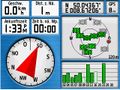
Hashproof

Not quite a grin.


Achievements
Well, Land. Possibly "Drowned rat", but not quite.