Difference between revisions of "2014-02-21 49 8"
imported>DODO (→Expedition) |
m (per Renaming Proposal) |
||
| (8 intermediate revisions by 4 users not shown) | |||
| Line 15: | Line 15: | ||
}} | }} | ||
| − | + | [[2014-02-08_49_8|previous]] [[2014-02-23 49 8|next]] | |
| + | |||
__NOTOC__ | __NOTOC__ | ||
== Location == | == Location == | ||
| − | + | ||
In Sandhausen, maybe not reachable. | In Sandhausen, maybe not reachable. | ||
== Participants == | == Participants == | ||
| − | + | ||
| − | |||
* [[User:DODO|DODO]] | * [[User:DODO|DODO]] | ||
== Plans == | == Plans == | ||
| − | + | ||
Although the hashpoint may be on private property, [[User:DODO|DODO]] will have a look tomorrow morning before work. Especially because he has never been in Sandhausen before. | Although the hashpoint may be on private property, [[User:DODO|DODO]] will have a look tomorrow morning before work. Especially because he has never been in Sandhausen before. | ||
== Expedition == | == Expedition == | ||
| − | + | ||
| − | As a geohash-starter I still have lack of patience, and so after the hashpoint being to far away for two weeks I had to try this one. So I decided to make a 20 KM detour on my way to work. On my way I came along Burg Wersau but nothing but a sign was visible of the former castle anymore. Short time later I reached the Hockenheimer Wald and crossed two ditches. The weather is fine, the air is fresh and me and my bull enjoy the freedom and the speed. At schoolstart we reach Sandhausen and the hashpoint gets nearer and nearer. I tie the bull down and try to get there, but 40 m before the hashpoint a thick copse started just in the middle of the town. I walk around the complete insula, but thats the nearest you can get to the hashpoint and all the way to it is impracticable. OK, maybe I could try to fight the raptors down, its only 40 meters, but then I have to | + | As a geohash-starter I still have lack of patience, and so after the hashpoint being to far away for two weeks I had to try this one. So I decided to make a 20 KM detour on my way to work. On my way I came along [[wikipedia:de:Burg_Wersau|Burg Wersau]] but nothing but a sign was visible of the former castle anymore. Short time later I reached the Hockenheimer Wald and crossed two ditches. |
| + | |||
| + | The weather is fine, the air is fresh and me and my bull enjoy the freedom and the speed. At schoolstart we reach Sandhausen and the hashpoint gets nearer and nearer. I tie the bull down and try to get there, but 40 m before the hashpoint a thick copse started just in the middle of the town. I walk around the complete insula, but thats the nearest you can get to the hashpoint and all the way to it is impracticable. | ||
| + | |||
| + | OK, maybe I could try to fight the raptors down, its only 40 meters, but then I have to go to work with clawmarks all over. | ||
| + | |||
| + | And there is a bakery next to the hashpoint, so I can have a consolation :-) | ||
== Tracklog == | == Tracklog == | ||
<!-- if your GPS device keeps a log, you may post a link here --> | <!-- if your GPS device keeps a log, you may post a link here --> | ||
| + | [http://www.gpsies.com/map.do?fileId=wrkzkfuerzvjyvxa bull: 38 KM (instead of 17)]. Since I didn't reach the hash, I didn't store the track, but I still have the plan, that I can link here. | ||
== Photos == | == Photos == | ||
| − | + | ||
| − | |||
| − | |||
<gallery perrow="5"> | <gallery perrow="5"> | ||
| + | Image:2014-02-21_49_8-1.jpg|All thats left of Burg Wersau | ||
| + | Image:2014-02-21_49_8-2.jpg|And that's how it looks today | ||
| + | Image:2014-02-21_49_8-3.jpg|First ditch | ||
| + | Image:2014-02-21_49_8-4.jpg|second ditch | ||
| + | Image:2014-02-21_49_8-6.jpg|dense cops (40 m to the hashpoint like that) | ||
| + | Image:2014-02-21_49_8-9.jpg|From the other side of the insula. Its behind the trees | ||
| + | Image:2014-02-21_49_8-8.jpg|Sandhausen church | ||
| + | Image:2014-02-21_49_8-10.jpg|Sandhausen school | ||
| + | Image:2014-02-21_49_8-11.jpg|Sandhausen monument (Schindelmache/clapboard maker) | ||
| + | Image:2014-02-21_49_8-12.jpg|Sandhausen museum | ||
| + | Image:2014-02-03_49_8-13.jpg|consolation | ||
| + | Image:2014-02-03_49_8-14.jpg|tied bull | ||
</gallery> | </gallery> | ||
== Achievements == | == Achievements == | ||
{{#vardefine:ribbonwidth|800px}} | {{#vardefine:ribbonwidth|800px}} | ||
| − | |||
| + | {{done with nature | ||
| + | | latitude = 49 | ||
| + | | longitude = 8 | ||
| + | | date = 2014-02-21 | ||
| + | | name = DODO | ||
| + | | image = 2014-02-21_49_8-6.jpg | ||
| + | }} | ||
| − | |||
| − | |||
| − | + | [[Category:Expeditions]] | |
| − | |||
| − | |||
| − | |||
| − | [[Category: | ||
| − | |||
| − | |||
| − | |||
| − | |||
[[Category:Expeditions with photos]] | [[Category:Expeditions with photos]] | ||
| − | |||
| − | |||
| − | |||
| − | |||
| − | |||
| − | |||
| − | |||
| − | |||
| − | |||
[[Category:Coordinates not reached]] | [[Category:Coordinates not reached]] | ||
[[Category:Not reached - Mother Nature]] | [[Category:Not reached - Mother Nature]] | ||
| − | + | {{location|DE|BW|HD}} | |
| − | |||
| − | |||
| − | |||
| − | |||
| − | |||
| − | |||
| − | |||
| − | |||
| − | |||
| − | |||
| − | |||
| − | |||
| − | |||
Latest revision as of 14:32, 2 April 2024
| Fri 21 Feb 2014 in 49,8: 49.3437648, 8.6563808 geohashing.info google osm bing/os kml crox |
Location
In Sandhausen, maybe not reachable.
Participants
Plans
Although the hashpoint may be on private property, DODO will have a look tomorrow morning before work. Especially because he has never been in Sandhausen before.
Expedition
As a geohash-starter I still have lack of patience, and so after the hashpoint being to far away for two weeks I had to try this one. So I decided to make a 20 KM detour on my way to work. On my way I came along Burg Wersau but nothing but a sign was visible of the former castle anymore. Short time later I reached the Hockenheimer Wald and crossed two ditches.
The weather is fine, the air is fresh and me and my bull enjoy the freedom and the speed. At schoolstart we reach Sandhausen and the hashpoint gets nearer and nearer. I tie the bull down and try to get there, but 40 m before the hashpoint a thick copse started just in the middle of the town. I walk around the complete insula, but thats the nearest you can get to the hashpoint and all the way to it is impracticable.
OK, maybe I could try to fight the raptors down, its only 40 meters, but then I have to go to work with clawmarks all over.
And there is a bakery next to the hashpoint, so I can have a consolation :-)
Tracklog
bull: 38 KM (instead of 17). Since I didn't reach the hash, I didn't store the track, but I still have the plan, that I can link here.
Photos
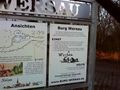
All thats left of Burg Wersau
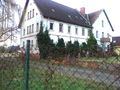
And that's how it looks today
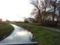
First ditch
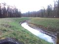
second ditch
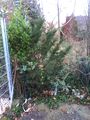
dense cops (40 m to the hashpoint like that)
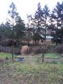
From the other side of the insula. Its behind the trees
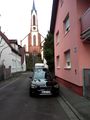
Sandhausen church
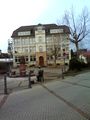
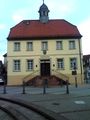
Sandhausen school
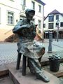
Sandhausen monument (Schindelmache/clapboard maker)
Sandhausen museum
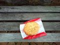
consolation
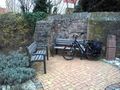
tied bull


Achievements
DODO earned the Done with Nature consolation prize
|