Difference between revisions of "2014-02-23 50 8"
From Geohashing
imported>Yakamoz (→Photos) |
imported>FippeBot m (Location) |
||
| (7 intermediate revisions by 2 users not shown) | |||
| Line 18: | Line 18: | ||
__NOTOC__ | __NOTOC__ | ||
== Location == | == Location == | ||
| − | + | On a field outside the small village Rechtenbach (Hesse) | |
== Participants == | == Participants == | ||
| − | + | ||
| − | + | [[User:Yakamoz|Yakamoz]] and [[User:Rincewind|Rincewind]] | |
== Plans == | == Plans == | ||
| Line 28: | Line 28: | ||
== Expedition == | == Expedition == | ||
| − | + | We drove to Rechtenbach with Rincewinds car. We parked the car 600 m from the geohash point. Then we walked towards the coordinates. The weather was sunny and nice. We enjoyed our stroll. For the last 80 m Rincewind had to walk into the field. Yakamoz took some photos. After reaching the coordinates we continued our walk. | |
== Tracklog == | == Tracklog == | ||
| Line 40: | Line 40: | ||
Image:2014-02-23_50_8_17-50-39-035.jpg | On the way | Image:2014-02-23_50_8_17-50-39-035.jpg | On the way | ||
| − | |||
Image:2014-02-23_50_8_17-52-36-237.jpg | Yay | Image:2014-02-23_50_8_17-52-36-237.jpg | Yay | ||
| − | |||
Image:2014-02-23_50_8_17-53-44-984.jpg | Done! | Image:2014-02-23_50_8_17-53-44-984.jpg | Done! | ||
| − | |||
Image:2014-02-23_50_8_17-54-54-676.jpg | Happy geohashers | Image:2014-02-23_50_8_17-54-54-676.jpg | Happy geohashers | ||
| + | Image:2014-02-23_50_8_hashproof.jpg | Proof. | ||
</gallery> | </gallery> | ||
== Achievements == | == Achievements == | ||
| − | {{ | + | {{Land geohash| |
| − | + | latitude= 50 | | |
| − | + | longitude=8 | | |
| − | + | name=Yakamoz and Rincewind | | |
| − | + | date=2014-02-23 | |
| − | + | }} | |
| − | |||
| − | |||
| − | |||
| − | |||
| − | |||
| − | |||
| − | |||
| − | |||
[[Category:Expeditions]] | [[Category:Expeditions]] | ||
| − | |||
[[Category:Expeditions with photos]] | [[Category:Expeditions with photos]] | ||
| − | |||
| − | |||
| − | |||
| − | |||
| − | |||
[[Category:Coordinates reached]] | [[Category:Coordinates reached]] | ||
| − | + | {{location|DE|HE|LDK}} | |
| − | |||
| − | |||
| − | |||
| − | |||
| − | |||
| − | |||
| − | |||
| − | |||
| − | |||
| − | |||
| − | |||
| − | |||
| − | |||
| − | |||
| − | |||
| − | |||
| − | |||
Latest revision as of 05:38, 14 August 2019
| Sun 23 Feb 2014 in 50,8: 50.5180912, 8.5579196 geohashing.info google osm bing/os kml crox |
Location
On a field outside the small village Rechtenbach (Hesse)
Participants
Plans
Expedition
We drove to Rechtenbach with Rincewinds car. We parked the car 600 m from the geohash point. Then we walked towards the coordinates. The weather was sunny and nice. We enjoyed our stroll. For the last 80 m Rincewind had to walk into the field. Yakamoz took some photos. After reaching the coordinates we continued our walk.
Tracklog
Photos
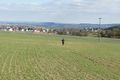
On the way
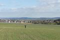
Yay
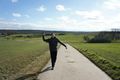
Done!
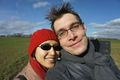
Happy geohashers
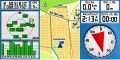
Proof.


Achievements
Yakamoz and Rincewind earned the Land geohash achievement
|