Difference between revisions of "2014-02-25 -35 149"
From Geohashing
imported>1PE |
imported>1PE |
||
| Line 28: | Line 28: | ||
== Expedition == | == Expedition == | ||
| − | + | * [[User:1PE|1PE]] | |
| + | :It was about 10.30pm when I'd finished up several other activities for the evening, and got to drive a short distance from home to the hash. The road surfaces on the main road were being repaired, and new lines marked at several corners. Detour time. | ||
| + | |||
| + | :I parked beside a road machine and walked into the bush, using a mobile phone's dull glow to prevent tripping on the tall grass and hidden rocks. Down by the creek, I could see the dam wall at the nearby road (the road crosses the dam wall) and navigated in using the phone's locator. | ||
| + | |||
| + | :After several pics, I walked back. | ||
| + | |||
== Tracklog == | == Tracklog == | ||
| Line 38: | Line 44: | ||
--> | --> | ||
<gallery perrow="5"> | <gallery perrow="5"> | ||
| + | Image:2014-02-25_-35_149_084.jpg|Road, dam, spillway, creek, hash. | ||
| + | Image:2014-02-25_-35_149_088.jpg|Why AM I doing this late at night? | ||
| + | Image:2014-02-25_-35_149_091.jpg|Leg of a power line tower. | ||
| + | Image:2014-02-25_-35_149_092.jpg|Serious late-night road building at the nearby corner meant I had several detours. | ||
</gallery> | </gallery> | ||
| Line 49: | Line 59: | ||
[[Category:New report]] | [[Category:New report]] | ||
| − | |||
| − | |||
| − | |||
| − | |||
[[Category:Expeditions]] | [[Category:Expeditions]] | ||
| − | |||
[[Category:Expeditions with photos]] | [[Category:Expeditions with photos]] | ||
| − | + | ||
| − | |||
| − | |||
| − | |||
| − | |||
[[Category:Coordinates reached]] | [[Category:Coordinates reached]] | ||
| − | |||
| − | |||
| − | |||
| − | |||
| − | |||
| − | |||
| − | |||
| − | |||
| − | |||
| − | |||
| − | |||
| − | |||
| − | |||
| − | |||
| − | |||
| − | |||
| − | |||
| − | |||
Revision as of 12:35, 25 February 2014
| Tue 25 Feb 2014 in -35,149: -35.2212266, 149.0685680 geohashing.info google osm bing/os kml crox |
Location
On the bank of Ginninderra Creek, an important, local, urban creek in the Belconnen region of Canberra, beside the overflow dam of Lake Ginninderra.
Participants
Plans
- 1PE
- Well after dark, after several social activities tonight.
Expedition
- It was about 10.30pm when I'd finished up several other activities for the evening, and got to drive a short distance from home to the hash. The road surfaces on the main road were being repaired, and new lines marked at several corners. Detour time.
- I parked beside a road machine and walked into the bush, using a mobile phone's dull glow to prevent tripping on the tall grass and hidden rocks. Down by the creek, I could see the dam wall at the nearby road (the road crosses the dam wall) and navigated in using the phone's locator.
- After several pics, I walked back.
Tracklog
Photos

Road, dam, spillway, creek, hash.

Why AM I doing this late at night?

Leg of a power line tower.
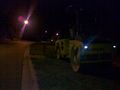
Serious late-night road building at the nearby corner meant I had several detours.


