Difference between revisions of "2014-02-26 48 17"
imported>Korhul |
imported>FippeBot m (Location) |
||
| (7 intermediate revisions by one other user not shown) | |||
| Line 1: | Line 1: | ||
| − | |||
| − | |||
| − | |||
| − | |||
| − | |||
| − | |||
| − | |||
| − | |||
| − | |||
| − | |||
{{meetup graticule | {{meetup graticule | ||
| lat=48 | | lat=48 | ||
| Line 14: | Line 4: | ||
| date=2014-02-26 | | date=2014-02-26 | ||
}} | }} | ||
| + | __NOTOC__ | ||
| − | |||
| − | |||
== Location == | == Location == | ||
| − | + | Almost on the shore of the lake situated nearby the village I live in. | |
== Participants == | == Participants == | ||
| Line 29: | Line 18: | ||
During the last few weeks I was permanently watching geohashing app on my phone, eagerly awaiting for my first geohash to appear somewhere close to me. Finally today a geohash was generated within my reach! I was really excited during the whole day although I had to be at work. | During the last few weeks I was permanently watching geohashing app on my phone, eagerly awaiting for my first geohash to appear somewhere close to me. Finally today a geohash was generated within my reach! I was really excited during the whole day although I had to be at work. | ||
| − | Expedition itself din't require much planing. I was familiar with the place as the hash was on the shore of the beatiful lake where I go swimming in the summer. All I had to do was take my bike and ride past my village near the forests. But because I got home | + | Expedition itself din't require much planing. I was familiar with the place as the hash was on the shore of the beatiful lake where I go swimming in the summer. All I had to do was to take my bike and ride past my village near the forests. But because I got home quite late today (arround 17:00) I had to go imnediately, because sun was already almost set. After about 15 minutes I got to the spot. |
I turned my phone on and tried to get to the exact spot. It has quite weak GPS reciever, so the margin of error was quite large (about 10 meters on average, see screenshot). During the process I was going round and round so I am pretty sure I managed to step right on there sometime during my stay. | I turned my phone on and tried to get to the exact spot. It has quite weak GPS reciever, so the margin of error was quite large (about 10 meters on average, see screenshot). During the process I was going round and round so I am pretty sure I managed to step right on there sometime during my stay. | ||
| Line 47: | Line 36: | ||
== Achievements == | == Achievements == | ||
{{#vardefine:ribbonwidth|800px}} | {{#vardefine:ribbonwidth|800px}} | ||
| − | |||
{{land geohash | {{land geohash | ||
| Line 61: | Line 49: | ||
| date = 2014-02-26 | | date = 2014-02-26 | ||
| name = [[User:Korhul|Korhul]] | | name = [[User:Korhul|Korhul]] | ||
| − | | distance = 4. | + | | distance = 4.0 km |
| bothways = true | | bothways = true | ||
}} | }} | ||
| − | |||
| − | |||
| − | |||
[[Category:Expeditions]] | [[Category:Expeditions]] | ||
[[Category:Expeditions with photos]] | [[Category:Expeditions with photos]] | ||
[[Category:Coordinates reached]] | [[Category:Coordinates reached]] | ||
| − | + | {{location|CZ|JM|4}} | |
| − | |||
| − | |||
Latest revision as of 05:40, 14 August 2019
| Wed 26 Feb 2014 in 48,17: 48.7899636, 17.0498246 geohashing.info google osm bing/os kml crox |
Location
Almost on the shore of the lake situated nearby the village I live in.
Participants
Plans
I wanted to take bike and go there before the sun sets.
Expedition
During the last few weeks I was permanently watching geohashing app on my phone, eagerly awaiting for my first geohash to appear somewhere close to me. Finally today a geohash was generated within my reach! I was really excited during the whole day although I had to be at work.
Expedition itself din't require much planing. I was familiar with the place as the hash was on the shore of the beatiful lake where I go swimming in the summer. All I had to do was to take my bike and ride past my village near the forests. But because I got home quite late today (arround 17:00) I had to go imnediately, because sun was already almost set. After about 15 minutes I got to the spot.
I turned my phone on and tried to get to the exact spot. It has quite weak GPS reciever, so the margin of error was quite large (about 10 meters on average, see screenshot). During the process I was going round and round so I am pretty sure I managed to step right on there sometime during my stay.
I took some pictures and listened to the sounds of the ducks which were floating on the lake and ravens or crows hidden somewhere in the nearby forests. Meanwhile dusk was upon me, so I turned myself to my way home.
The whole expedition took me about one hour and I really enjoyed it.
Photos
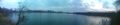
Panoramatic view of the lakes taken shortly before I arrived to the place.
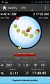
Screenshot from my phone. Not the exact coordinates, but close enough. Only at home I discovered that there is not date there!

Panoramatic view from the geohash. You can see my sisters bike I used to get there.

The other side of the view.

Achievements
Korhul earned the Land geohash achievement
|
Korhul earned the Bicycle geohash achievement
|