Difference between revisions of "2014-02-27 47 8"
imported>Calamus |
imported>FippeBot m (Location) |
||
| (6 intermediate revisions by 2 users not shown) | |||
| Line 1: | Line 1: | ||
| − | |||
| − | |||
| − | |||
| − | |||
| − | |||
| − | |||
| − | |||
| − | |||
| − | |||
{{meetup graticule | {{meetup graticule | ||
| lat=47 | | lat=47 | ||
| Line 20: | Line 11: | ||
== Participants == | == Participants == | ||
| − | [[User:Calamus|Calamus]] | + | *[[User:Calamus|Calamus]] |
| + | *[[User:Chris 47 8|Chris 47 8]] | ||
== Plans == | == Plans == | ||
| − | # S14 train leaving Zurich 3 at | + | ===Calamus=== |
| − | # 12 tram at | + | # S14 train leaving Zurich 3 at 11.12am to Wallisellen |
| + | # 12 tram at 11.27 to Belair | ||
# Walk | # Walk | ||
== Expedition == | == Expedition == | ||
| − | + | ===Calamus=== | |
| + | The best-known counting-out game in germanic Switzerland is about a cat going to the town of Wallisellen by foot, resulting in a severe case of osteoarthritis. "Counting-out game" was also a very good description for some recent events in Switzerland — but this is not the place for petty politics. On a possibly related note, Calamus had been very busy ever since the 9<sup>th</sup> of february, preventing him from geohashing. | ||
| + | |||
| + | Now, however, he needed to take his mind off work for a moment. And a hashpoint so close to Zurich was a great opportunity to do so. | ||
| + | |||
| + | The journey to Wallisellen was trivial, and from there the Glatttalbahn was the best means to continue. The Glatttalbahn is basically a tram, except that it goes as far out of the city as to the airport and has its own overhead bridges. From the Belair station, a narrow path led along the rails towards the hashpoint, which lay just next to the path on a field. And the field was fenced. However, the distance was sufficiently small for the expedition to be considered a success. | ||
| + | |||
| + | And back to work it was. | ||
| + | |||
| + | ==== Horizon 2020 ==== | ||
| + | :Aazelè, Bölè schelè | ||
| + | :Ich han EU-Chölè welè. | ||
| + | :D'SVP säit: «Näi, | ||
| + | :D'Schwiiz cha das èläi.» | ||
| + | :Das isch Stuss | ||
| + | :und miir sind duss. | ||
| + | |||
| + | ===Chris=== | ||
| + | Wallisellen. Alright then. Wallisellen ist a suburban town of Zurich with a funny name. Maybe that's the reason it appears in a children rhyme in swiss german which goes 'D chatz goht uf Walliselle', which means 'The cat goes to Wallisellen'. That's why probably every kid in Switzerland knows this town. At least by name. And a famous swiss folk singer named Stiller Has wrote a song called Walliselle, satirically pointing out that there are probably nicer places in the country than that one.<br> | ||
| + | So, it's just another suburban town of Zurich. Houses, Streets, Toys'r'us and Ikea. And a geohash, which lies just in between an industrial area, a railway line and a highway intersection. Right under an approach corridor of the airport. Lovely. Probably the noisiest hash point ever.<br> | ||
| + | No reason to not go there. I took the S12 train to Stettbach, and tram 12 from there right to Belair station. I walked to the spot and found the coordinates. There was a fence which i didn't want to cross, so i was probably 3 meters from the actual place, but i think thats still okay. While looking for the coordinates i really had to look hard for all the dog turds that were laying around there. Urgh. Anyways, i took a few pictures and went home. Farewell, Wallisellen! | ||
== Tracklog == | == Tracklog == | ||
| − | + | n/a | |
== Photos == | == Photos == | ||
| − | < | + | |
| − | Image: | + | <gallery perrow="4"> |
| − | -- | + | Image:2014-02-27_47_8-01.JPG|The spot. View to the west. |
| − | + | Image:2014-02-27_47_8-02.PNG|Close enough. | |
| + | Image:2014-02-27_47_8-03.PNG|Coordinates reached, more or less. | ||
| + | Image:2014-02-27 47 8 hashpoint.jpg|Same for Calamus. | ||
| + | Image:2014-02-27_47_8-04.JPG|Industry. | ||
| + | Image:2014-02-27_47_8-05.JPG|Suburban train. | ||
| + | |||
</gallery> | </gallery> | ||
== Achievements == | == Achievements == | ||
| − | + | none of interest. | |
| − | |||
| − | |||
| − | |||
| − | |||
[[Category:Expeditions]] | [[Category:Expeditions]] | ||
| − | |||
[[Category:Expeditions with photos]] | [[Category:Expeditions with photos]] | ||
| − | |||
| − | |||
| − | |||
| − | |||
| − | |||
[[Category:Coordinates reached]] | [[Category:Coordinates reached]] | ||
| − | + | {{location|CH|ZH}} | |
| − | |||
| − | |||
| − | |||
| − | |||
| − | |||
| − | |||
| − | |||
| − | |||
| − | |||
| − | |||
| − | |||
| − | |||
| − | |||
| − | |||
| − | |||
| − | |||
| − | |||
Latest revision as of 05:41, 14 August 2019
| Thu 27 Feb 2014 in 47,8: 47.4130949, 8.5791287 geohashing.info google osm bing/os kml crox |
Location
A meadow in Wallisellen.
Participants
Plans
Calamus
- S14 train leaving Zurich 3 at 11.12am to Wallisellen
- 12 tram at 11.27 to Belair
- Walk
Expedition
Calamus
The best-known counting-out game in germanic Switzerland is about a cat going to the town of Wallisellen by foot, resulting in a severe case of osteoarthritis. "Counting-out game" was also a very good description for some recent events in Switzerland — but this is not the place for petty politics. On a possibly related note, Calamus had been very busy ever since the 9th of february, preventing him from geohashing.
Now, however, he needed to take his mind off work for a moment. And a hashpoint so close to Zurich was a great opportunity to do so.
The journey to Wallisellen was trivial, and from there the Glatttalbahn was the best means to continue. The Glatttalbahn is basically a tram, except that it goes as far out of the city as to the airport and has its own overhead bridges. From the Belair station, a narrow path led along the rails towards the hashpoint, which lay just next to the path on a field. And the field was fenced. However, the distance was sufficiently small for the expedition to be considered a success.
And back to work it was.
Horizon 2020
- Aazelè, Bölè schelè
- Ich han EU-Chölè welè.
- D'SVP säit: «Näi,
- D'Schwiiz cha das èläi.»
- Das isch Stuss
- und miir sind duss.
Chris
Wallisellen. Alright then. Wallisellen ist a suburban town of Zurich with a funny name. Maybe that's the reason it appears in a children rhyme in swiss german which goes 'D chatz goht uf Walliselle', which means 'The cat goes to Wallisellen'. That's why probably every kid in Switzerland knows this town. At least by name. And a famous swiss folk singer named Stiller Has wrote a song called Walliselle, satirically pointing out that there are probably nicer places in the country than that one.
So, it's just another suburban town of Zurich. Houses, Streets, Toys'r'us and Ikea. And a geohash, which lies just in between an industrial area, a railway line and a highway intersection. Right under an approach corridor of the airport. Lovely. Probably the noisiest hash point ever.
No reason to not go there. I took the S12 train to Stettbach, and tram 12 from there right to Belair station. I walked to the spot and found the coordinates. There was a fence which i didn't want to cross, so i was probably 3 meters from the actual place, but i think thats still okay. While looking for the coordinates i really had to look hard for all the dog turds that were laying around there. Urgh. Anyways, i took a few pictures and went home. Farewell, Wallisellen!
Tracklog
n/a
Photos
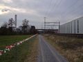
The spot. View to the west.
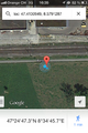
Close enough.

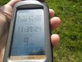
Coordinates reached, more or less.
Same for Calamus.
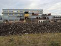
Industry.
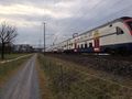
Suburban train.


Achievements
none of interest.