Difference between revisions of "2014-02-27 51 9"
imported>GeorgDerReisende (new expedition) |
imported>FippeBot m (Location) |
||
| (One intermediate revision by one other user not shown) | |||
| Line 1: | Line 1: | ||
| − | |||
| − | |||
| − | |||
| − | |||
| − | |||
| − | |||
| − | |||
| − | |||
| − | |||
| − | |||
{{meetup graticule | {{meetup graticule | ||
| lat=51 | | lat=51 | ||
| Line 18: | Line 8: | ||
__NOTOC__ | __NOTOC__ | ||
== Location == | == Location == | ||
| − | + | ||
| + | The hash lies in the forest of Wilhelmshausen. | ||
== Participants == | == Participants == | ||
| − | + | ||
| − | + | [[User:GeorgDerReisende|GeorgDerReisende]] | |
== Plans == | == Plans == | ||
| − | + | ||
| + | To go there, by bus and by hitchhiking, do the usual things, and then decide, whether to go home or to [[2014-02-27 52 9]]. | ||
== Expedition == | == Expedition == | ||
| − | |||
| − | + | I left home at 8:10, walked to Ihringshausen, took there the bus 42 until Schocketal and started there to hitchhike. I waited for one hour and got a car to Wilhelmshausen. There I walked through the village and then into the forest. I passed two gates, and then I found it, the hash. After a short dance I got the 0 meter distance. Then I walked back to the national road and I decided to make [[2014-02-27 52 9]] too. | |
| − | |||
== Photos == | == Photos == | ||
| − | |||
| − | |||
| − | |||
<gallery perrow="5"> | <gallery perrow="5"> | ||
| + | Image:2014-02-27 51 9 GeorgDerReisende 6296.jpg | arrived at Wilhelmshausen at 10:02 | ||
| + | Image:2014-02-27 51 9 GeorgDerReisende 6298.jpg | walking up the street Kötnerei | ||
| + | Image:2014-02-27 51 9 GeorgDerReisende 6299.jpg | I have seen two sheep | ||
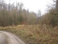
| + | Image:2014-02-27 51 9 GeorgDerReisende 6300.jpg | the first gate | ||
| + | Image:2014-02-27 51 9 GeorgDerReisende 6302.jpg | the second gate | ||
| + | Image:2014-02-27 51 9 GeorgDerReisende 6312.jpg | proof 1 | ||
| + | Image:2014-02-27 51 9 GeorgDerReisende 6317.jpg | proof 2 | ||
| + | Image:2014-02-27 51 9 GeorgDerReisende 6313.jpg | look around... | ||
| + | Image:2014-02-27 51 9 GeorgDerReisende 6314.jpg | ... | ||
| + | Image:2014-02-27 51 9 GeorgDerReisende 6315.jpg | ... | ||
| + | Image:2014-02-27 51 9 GeorgDerReisende 6316.jpg | ... | ||
| + | Image:2014-02-27 51 9 GeorgDerReisende 6319.jpg | stupid grin | ||
| + | Image:2014-02-27 51 9 GeorgDerReisende 6320.jpg | looking back to the hash | ||
| + | Image:2014-02-27 51 9 GeorgDerReisende 6321.jpg | the brook in the valley | ||
| + | Image:2014-02-27 51 9 GeorgDerReisende 6329.jpg | the river Fulda | ||
</gallery> | </gallery> | ||
| Line 44: | Line 46: | ||
<!-- Add any achievement ribbons you earned below, or remove this section --> | <!-- Add any achievement ribbons you earned below, or remove this section --> | ||
| + | {{Thumbs Up | latitude = 51 | longitude = 9 | date = 2014-02-27 | name = GeorgDerReisende }} | ||
| − | + | [[Category:Expeditions]] | |
| − | |||
| − | [[Category: | ||
| − | + | [[Category:Expeditions with photos]] | |
| − | |||
| − | |||
| − | |||
| − | [[Category: | ||
| − | |||
| − | |||
| − | |||
| − | |||
| − | |||
| − | |||
| − | |||
| − | |||
| − | |||
| − | |||
[[Category:Coordinates reached]] | [[Category:Coordinates reached]] | ||
| − | + | {{location|DE|HE|KS}} | |
| − | |||
| − | |||
| − | |||
| − | |||
| − | |||
| − | |||
| − | |||
| − | |||
| − | |||
| − | |||
| − | |||
| − | |||
| − | |||
| − | |||
| − | |||
| − | |||
| − | |||
Latest revision as of 05:41, 14 August 2019
| Thu 27 Feb 2014 in 51,9: 51.4130949, 9.5791287 geohashing.info google osm bing/os kml crox |
Location
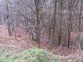
The hash lies in the forest of Wilhelmshausen.
Participants
Plans
To go there, by bus and by hitchhiking, do the usual things, and then decide, whether to go home or to 2014-02-27 52 9.
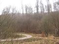
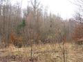
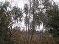
Expedition
I left home at 8:10, walked to Ihringshausen, took there the bus 42 until Schocketal and started there to hitchhike. I waited for one hour and got a car to Wilhelmshausen. There I walked through the village and then into the forest. I passed two gates, and then I found it, the hash. After a short dance I got the 0 meter distance. Then I walked back to the national road and I decided to make 2014-02-27 52 9 too.
Photos
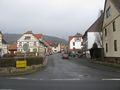
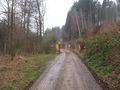
arrived at Wilhelmshausen at 10:02
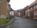
walking up the street Kötnerei
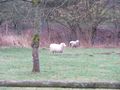
I have seen two sheep
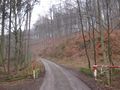
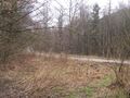
the first gate
the second gate
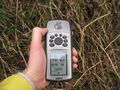
proof 1
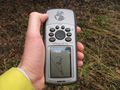
proof 2
look around...
...
...
...
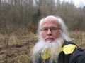
stupid grin
looking back to the hash
the brook in the valley
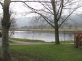
the river Fulda


Achievements
GeorgDerReisende earned the Thumbs Up Geohash Achievement
|