Difference between revisions of "2014-02-27 52 4"
imported>Eupeodes (→Photos) |
imported>FippeBot m (Location) |
||
| (3 intermediate revisions by one other user not shown) | |||
| Line 32: | Line 32: | ||
== Expedition == | == Expedition == | ||
<!-- how it all turned out. your narrative goes here. --> | <!-- how it all turned out. your narrative goes here. --> | ||
| − | Somewhere in the morning it started raining and it continued long in the afternoon. This made me doubt whether I would go or not. Stayed long at work and somewhere after 5 it got dryish. I decided to go for it at half past 5, so 45 minutes before sunset, it would only take me 15 minutes to get there, 5 minutes at the spot and 15 minutes to get back. So still very possible before sunset. Well... It turned out differently. Although it was only 5 kilometers in a straight line over the road the distance doubled. Also 750 meters from the hash there was a sign telling it was not allowed to cycle further or even bring your bike along. So I left the bike and continued on foot. Reaching it wasn't hard and I took the pictures. Now I only had 10 minutes left before sunset in which I had to walk back to my bike and get out of the area. 10 km in 10 minutes is a bit to ambitious, and the trip would lead me past the house of the ranger. I was close to the southern edge so I decided to leave the dunes to the south. Now I only had the problem that I was at the south of the area while my house is at the North. I had to cycle around it. The total distance I cycled was .. km. And the whole expedition only took me 2 hours (where I expected half an hour). | + | Somewhere in the morning it started raining and it continued long in the afternoon. This made me doubt whether I would go or not. Stayed long at work and somewhere after 5 it got dryish. I decided to go for it at half past 5, so 45 minutes before sunset, it would only take me 15 minutes to get there, 5 minutes at the spot and 15 minutes to get back. So still very possible before sunset. Well... It turned out differently. Although it was only 5 kilometers in a straight line over the road the distance doubled. Also 750 meters from the hash there was a sign telling it was not allowed to cycle further or even bring your bike along. So I left the bike and continued on foot. Reaching it wasn't hard and I took the pictures. Now I only had 10 minutes left before sunset in which I had to walk back to my bike and get out of the area. 10 km in 10 minutes is a bit to ambitious, and the trip would lead me past the house of the ranger. I was close to the southern edge so I decided to leave the dunes to the south. Now I only had the problem that I was at the south of the area while my house is at the North. I had to cycle around it. The total distance I cycled was 27.8 km, and I walked 1.6 km. And the whole expedition only took me 2 hours (where I expected half an hour). |
| − | |||
| − | |||
| − | |||
== Photos == | == Photos == | ||
| Line 47: | Line 44: | ||
</gallery> | </gallery> | ||
| − | |||
| − | |||
| − | |||
| − | |||
| − | |||
| − | |||
| − | |||
| − | |||
| − | |||
| − | |||
| − | |||
| − | |||
| − | |||
| − | |||
| − | |||
| − | |||
| − | |||
[[Category:Expeditions]] | [[Category:Expeditions]] | ||
| − | |||
[[Category:Expeditions with photos]] | [[Category:Expeditions with photos]] | ||
| − | |||
| − | |||
| − | |||
| − | |||
| − | |||
[[Category:Coordinates reached]] | [[Category:Coordinates reached]] | ||
| − | + | {{location|NL|NH}} | |
| − | |||
| − | |||
| − | |||
| − | |||
| − | |||
| − | |||
| − | |||
| − | |||
| − | |||
| − | |||
| − | |||
| − | |||
| − | |||
| − | |||
| − | |||
| − | |||
| − | |||
Latest revision as of 05:41, 14 August 2019
| Thu 27 Feb 2014 in 52,4: 52.4130949, 4.5791287 geohashing.info google osm bing/os kml crox |
Location
In the dunes near Bloemendaal, access not allowed between sunset and sunrise!
Participants
Plans
Eupeodes plans to go there after work. Be there somewhere between 1715 and 1800 hours (work a full day, cycle to the hash and leave the area before sunset).
Expedition
Somewhere in the morning it started raining and it continued long in the afternoon. This made me doubt whether I would go or not. Stayed long at work and somewhere after 5 it got dryish. I decided to go for it at half past 5, so 45 minutes before sunset, it would only take me 15 minutes to get there, 5 minutes at the spot and 15 minutes to get back. So still very possible before sunset. Well... It turned out differently. Although it was only 5 kilometers in a straight line over the road the distance doubled. Also 750 meters from the hash there was a sign telling it was not allowed to cycle further or even bring your bike along. So I left the bike and continued on foot. Reaching it wasn't hard and I took the pictures. Now I only had 10 minutes left before sunset in which I had to walk back to my bike and get out of the area. 10 km in 10 minutes is a bit to ambitious, and the trip would lead me past the house of the ranger. I was close to the southern edge so I decided to leave the dunes to the south. Now I only had the problem that I was at the south of the area while my house is at the North. I had to cycle around it. The total distance I cycled was 27.8 km, and I walked 1.6 km. And the whole expedition only took me 2 hours (where I expected half an hour).
Photos
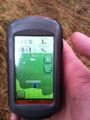
Proof

Grin
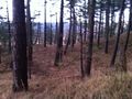
The area


