Difference between revisions of "2014-03-01 48 15"
From Geohashing
imported>B2c m (→Participants) |
m (per Renaming Proposal) |
||
| (5 intermediate revisions by 5 users not shown) | |||
| Line 67: | Line 67: | ||
| date = 2014-03-01 | | date = 2014-03-01 | ||
}} | }} | ||
| + | {{Graticule unlocked | latitude = 48 | longitude = 15 | date = 2014-03-01 | name = B2c | image = 2014-03-02.jpg}} | ||
| + | {{Graticule unlocked | latitude = 48 | longitude = 15 | date = 2014-03-01 | name = Micsnare | image = 2014-03-02.jpg}} | ||
| − | |||
| − | |||
| − | |||
| − | |||
| − | |||
| − | |||
| − | |||
| − | |||
| − | |||
| − | |||
| − | |||
| − | |||
| − | |||
| − | |||
[[Category:Expeditions]] | [[Category:Expeditions]] | ||
| − | |||
[[Category:Expeditions with photos]] | [[Category:Expeditions with photos]] | ||
| − | |||
| − | |||
| − | |||
| − | |||
| − | |||
[[Category:Coordinates reached]] | [[Category:Coordinates reached]] | ||
| − | + | {{location|AT|NÖ|PL}} | |
| − | |||
| − | |||
| − | |||
| − | |||
| − | |||
| − | |||
| − | |||
| − | |||
| − | |||
| − | |||
| − | |||
| − | |||
| − | |||
| − | |||
| − | |||
| − | |||
| − | |||
Latest revision as of 06:43, 20 March 2024
| Sat 1 Mar 2014 in 48,15: 48.2267331, 15.8631407 geohashing.info google osm bing/os kml crox |
Location
near St. Pölten, in Lower Austria (Austria)
Participants
Plans
B2c came up with the idea and invited me to come along with him on yet another geohash adventure. It was my very first time and I didn't quite know what to expect. Equipped with a DLSR camera, a few smartphones and lots of candy, we set out on my first hash.
We let the photos speak for itself, as you can see the hashpoint was more or less in the middle of nowhere ;-)
Expedition
- St. Pölten Hash 2014-03-01 mit theresa, yay! -- B2c (talk) @48.2267,15.8632 20:28, 1 March 2014 (CET)
Tracklog

Photos
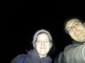
selfie of B2c and micsnare
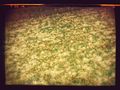
2nd hash that night, making it a multi-hash ;-)
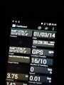
picture of the 2nd hash coordinates
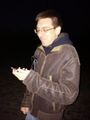
B2c having a laugh at our coordinates


Achievements
This user earned the Land geohash achievement
|
micsnare earned the Multihash Achievement
|
B2c earned the Graticule Unlocked Achievement
|
Micsnare earned the Graticule Unlocked Achievement
|