Difference between revisions of "2014-03-02 34 -118"
imported>Bravissimo594 (Created page.) |
imported>FippeBot m (Location) |
||
| (16 intermediate revisions by 2 users not shown) | |||
| Line 1: | Line 1: | ||
| + | {{Advert | ||
| + | |image=2014-03-02 34 -118-marker.png}} | ||
<!-- If you did not specify these parameters in the template, please substitute appropriate values for IMAGE, LAT, LON, and DATE (YYYY-MM-DD format) | <!-- If you did not specify these parameters in the template, please substitute appropriate values for IMAGE, LAT, LON, and DATE (YYYY-MM-DD format) | ||
| − | + | --> | |
| − | [[Image:{{{image| | + | [[Image:{{{image|2014-03-02 34 -118 11-50-02-875.jpg}}}|thumb|left]] |
| − | + | <!-- | |
Remove this section if you don't want an image at the top (left) of your report. You should remove the "Image:" or "File:" | Remove this section if you don't want an image at the top (left) of your report. You should remove the "Image:" or "File:" | ||
tag from your image file name, and replace the all upper-case word IMAGE in the above line. | tag from your image file name, and replace the all upper-case word IMAGE in the above line. | ||
| Line 15: | Line 17: | ||
}} | }} | ||
| − | + | ||
__NOTOC__ | __NOTOC__ | ||
== Location == | == Location == | ||
| − | + | ||
| + | Desert land in the alluvial plains west of Rosamond. [[Los Angeles, California|Los Angeles]] graticule, Kern County. | ||
== Participants == | == Participants == | ||
| − | + | ||
| − | + | * [[User:Bravissimo594|Bravissimo594]] | |
== Plans == | == Plans == | ||
| − | + | ||
| + | Weather permitting, I expect to arrive sometime between 9:00am and 11:00am to give the puppies a chance to stretch their legs. [[User:Bravissimo594|Bravissimo594]] ([[User talk:Bravissimo594|talk]]) 11:50, 28 February 2014 (EST) | ||
== Expedition == | == Expedition == | ||
<!-- how it all turned out. your narrative goes here. --> | <!-- how it all turned out. your narrative goes here. --> | ||
| + | === [[User:Bravissimo594|Bravissimo594]] ([[User talk:Bravissimo594|talk]]) === | ||
| + | I left the rain-soaked Los Angeles area at about 8:00am and made it as far as Lancaster by 9:30. The puppies and I stopped to fuel up and then headed out to look for local fauna on the way to the meetup. We found one hopper to play with in the 40 minutes of early hiking and then packed up to see if we could make the meetup. Muddy roads from the biggest rains in a few years gave the four-wheel drive a chance to get fluid flowing again in all of the differentials. Anyone who looks on a map will be misled by the names of streets in the Mojave Desert. If you only look at [https://goo.gl/maps/Xxr4g the Google Map for the neighborhood], you might think that "Avenue A and 160th St West" would be a significant intersection, ready for easy travel. But a glance at [http://maps.googleapis.com/maps/api/streetview?location=34.818863,-118.414&size=600x400&sensor=false&heading=340&pitch=-20&key=AIzaSyBVUV9FpdzJ2O6tmayt9WWeBW3Jj6iUDjM the Street View from Avenue A] shows the nature of the intersection. (Now imagine that dirt road with a couple of days' worth of rain on it.) | ||
| − | + | On 160th Street West, I could drive to a point due east of the hash point. I then let the dogs out and hiked about 500 meters from the road to the point. I placed a marker there, took some photos, and then headed back to the truck. I was able to avoid the deepest mud by heading north and east and back to pavement at 150th and Rosamond Boulevard. From there, I continued north to Tehachapi to visit a recovering friend. After a few hours in Tehachapi, the puppies and I got back home just after 6:00pm. | |
| − | |||
== Photos == | == Photos == | ||
| − | + | ||
| − | |||
| − | |||
<gallery perrow="5"> | <gallery perrow="5"> | ||
| + | |||
| + | Image:2014-03-02_34_-118_11-22-29-831.jpg | Geohash Droid success! [http://www.openstreetmap.org/?lat=34.84303212&lon=-118.41896092&zoom=16&layers=B000FTF @34.8430,-118.4190] | ||
| + | Image:2014-03-02_34_-118_11-23-12-428.jpg | Marker in place. [http://www.openstreetmap.org/?lat=34.84320000&lon=-118.42000000&zoom=16&layers=B000FTF @34.8432,-118.4200] | ||
| + | Image:2014-03-02_34_-118_11-24-44-237.jpg | Windmills in the distance. [http://www.openstreetmap.org/?lat=34.84320000&lon=-118.42000000&zoom=16&layers=B000FTF @34.8432,-118.4200] | ||
| + | Image:2014-03-02_34_-118_11-50-02-875.jpg | Four-wheel drive was the only way to get reasonably close. [http://www.openstreetmap.org/?lat=34.83330000&lon=-118.41400000&zoom=16&layers=B000FTF @34.8333,-118.4140] | ||
| + | |||
| + | Image:2014-03-02_34_-118_08-46-32-021.jpg | Long hike back to the truck parked on the horizon. [http://www.openstreetmap.org/?lat=34.84310000&lon=-118.41800000&zoom=16&layers=B000FTF @34.8431,-118.4180] | ||
</gallery> | </gallery> | ||
| Line 44: | Line 54: | ||
<!-- Add any achievement ribbons you earned below, or remove this section --> | <!-- Add any achievement ribbons you earned below, or remove this section --> | ||
| + | * Land Geohash | ||
| − | |||
| − | |||
| − | |||
| − | + | [[Category:Expeditions]] | |
| − | + | [[Category:Expeditions with photos]] | |
| − | |||
| − | |||
| − | |||
| − | |||
| − | |||
| − | |||
| − | |||
| − | [[Category:Expeditions with photos]] | ||
| − | |||
| − | |||
| − | |||
| − | |||
| − | |||
[[Category:Coordinates reached]] | [[Category:Coordinates reached]] | ||
| − | + | {{location|US|CA|KE}} | |
| − | |||
| − | |||
| − | |||
| − | |||
| − | |||
| − | |||
| − | |||
| − | |||
| − | |||
| − | |||
| − | |||
| − | |||
| − | |||
| − | |||
| − | |||
| − | |||
| − | |||
Latest revision as of 05:43, 14 August 2019
| Have you seen our geohashing marker? We'd love to hear from you! Click here to say "hi" and tell us what you've seen!
Curious about what geohashing is? Read more! |  |

| Sun 2 Mar 2014 in 34,-118: 34.8432415, -118.4196304 geohashing.info google osm bing/os kml crox |
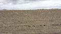
Location
Desert land in the alluvial plains west of Rosamond. Los Angeles graticule, Kern County.
Participants
Plans
Weather permitting, I expect to arrive sometime between 9:00am and 11:00am to give the puppies a chance to stretch their legs. Bravissimo594 (talk) 11:50, 28 February 2014 (EST)
Expedition
Bravissimo594 (talk)
I left the rain-soaked Los Angeles area at about 8:00am and made it as far as Lancaster by 9:30. The puppies and I stopped to fuel up and then headed out to look for local fauna on the way to the meetup. We found one hopper to play with in the 40 minutes of early hiking and then packed up to see if we could make the meetup. Muddy roads from the biggest rains in a few years gave the four-wheel drive a chance to get fluid flowing again in all of the differentials. Anyone who looks on a map will be misled by the names of streets in the Mojave Desert. If you only look at the Google Map for the neighborhood, you might think that "Avenue A and 160th St West" would be a significant intersection, ready for easy travel. But a glance at the Street View from Avenue A shows the nature of the intersection. (Now imagine that dirt road with a couple of days' worth of rain on it.)
On 160th Street West, I could drive to a point due east of the hash point. I then let the dogs out and hiked about 500 meters from the road to the point. I placed a marker there, took some photos, and then headed back to the truck. I was able to avoid the deepest mud by heading north and east and back to pavement at 150th and Rosamond Boulevard. From there, I continued north to Tehachapi to visit a recovering friend. After a few hours in Tehachapi, the puppies and I got back home just after 6:00pm.
Photos
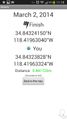
Geohash Droid success! @34.8430,-118.4190
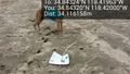
Marker in place. @34.8432,-118.4200
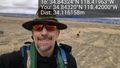
Windmills in the distance. @34.8432,-118.4200
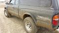
Four-wheel drive was the only way to get reasonably close. @34.8333,-118.4140
Long hike back to the truck parked on the horizon. @34.8431,-118.4180


Achievements
- Land Geohash