2014-03-02 34 -118
From Geohashing
Revision as of 16:46, 3 March 2014 by imported>Bravissimo594 ([retro picture] Long hike back to the truck parked on the horizon. [http://www.openstreetmap.org/?lat=34.84310000&lon=-118.41800000&zoom=16&layers=B000FTF @34.8431,-118.4180])
| Have you seen our geohashing marker? We'd love to hear from you! Click here to say "hi" and tell us what you've seen!
Curious about what geohashing is? Read more! |  |
| Sun 2 Mar 2014 in 34,-118: 34.8432415, -118.4196304 geohashing.info google osm bing/os kml crox |
Location
Desert land in the alluvial plains west of Rosamond. Los Angeles graticule.
Participants
Plans
Weather permitting, I expect to arrive sometime between 9:00am and 11:00am to give the puppies a chance to stretch their legs. Bravissimo594 (talk) 11:50, 28 February 2014 (EST)
Expedition
Tracklog
Photos
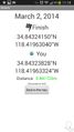
Geohash Droid success! @34.8430,-118.4190
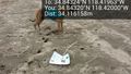
Marker in place. @34.8432,-118.4200
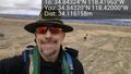
Windmills in the distance. @34.8432,-118.4200
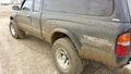
Four-wheel drive was the only way to get reasonably close. @34.8333,-118.4140
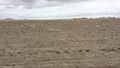
Long hike back to the truck parked on the horizon. @34.8431,-118.4180


Achievements
- Land Geohash