Difference between revisions of "2014-03-04 48 9"
imported>Kobras (An expedition message sent via Geohash Droid for Android.) |
imported>FippeBot m (Location) |
||
| (8 intermediate revisions by 3 users not shown) | |||
| Line 1: | Line 1: | ||
| − | |||
| − | |||
| − | |||
| − | |||
| − | |||
| − | |||
| − | |||
| − | |||
| − | |||
| − | |||
{{meetup graticule | {{meetup graticule | ||
| lat=48 | | lat=48 | ||
| Line 14: | Line 4: | ||
| date=2014-03-04 | | date=2014-03-04 | ||
}} | }} | ||
| − | |||
| − | |||
| − | |||
== Location == | == Location == | ||
| − | + | A road between the village of Waldhausen and the concrete cube district Waldhäuser-Ost at Tübingen. | |
== Participants == | == Participants == | ||
| − | + | Kobras | |
| − | |||
| − | + | Ekorren | |
| − | |||
== Expedition == | == Expedition == | ||
| − | + | === [[User:Kobras|Kobras]] === | |
| − | + | I just happened to look up this day's geohash just by chance, and what a conveniently located geohash it was! Right on the way to lunch, not even requiring a detour, heck not even leaving the car! I was accompanied by a couple of geocaching-savvy coworkers, so we also went for a cache close-by, making this probably the most nerdy lunch break, ever! (No meet up, unfortunately. I hope to spot the next hash location sooner than ten minutes before actually being there!) -- [[User:Kobras|Kobras]] ([[User talk:Kobras|talk]]) [http://www.openstreetmap.org/?lat=48.54396686&lon=9.05512602&zoom=16&layers=B000FTF @48.5440,9.0551] 06:51, 4 March 2014 (EST) | |
| − | |||
| − | == | + | === [[User:Ekorren|Ekorren]] === |
| − | |||
| − | |||
| − | |||
| − | |||
| − | |||
| − | + | Been there around noon by bike. Not much more to tell. | |
| − | |||
| − | |||
| + | It's another deja vu geohash, of course - this road is used by bus line 5 which I did ride countless times. I have also been here by bike frequently. | ||
| − | + | == Photos == | |
| − | + | <gallery> | |
| − | + | File:2014-03-04_48_9_ekorren_bus_at_hashpoint.JPG|Bus at hashpoint | |
| + | File:2014-03-04_48_9_ekorren_hashpoint.JPG|Hashpoint without bus | ||
| + | File:2014-03-04_48_9_ekorren_gps.JPG|coordinates reached | ||
| + | File:2014-03-04_48_9_ekorren_vfh_concrete.JPG|view from hash | ||
| + | File:2014-03-04_48_9_ekorren_vfh_trees.JPG|view from hash | ||
| + | </gallery> | ||
| − | |||
| − | + | {{ | |
| − | + | Déjà vu geohash| latitude = 48| longitude = 9| date = 2014-03-04| olddate = many times with bus line 5 or other transport | name = Ekorren | |
| − | + | }} | |
| − | |||
| − | |||
[[Category:Expeditions]] | [[Category:Expeditions]] | ||
| − | |||
[[Category:Expeditions with photos]] | [[Category:Expeditions with photos]] | ||
| − | |||
| − | |||
| − | |||
| − | |||
| − | |||
[[Category:Coordinates reached]] | [[Category:Coordinates reached]] | ||
| − | + | {{location|DE|BW|TÜ}} | |
| − | |||
| − | |||
| − | |||
| − | |||
| − | |||
| − | |||
| − | |||
| − | |||
| − | |||
| − | |||
| − | |||
| − | |||
| − | |||
| − | |||
| − | |||
| − | |||
| − | |||
Latest revision as of 05:45, 14 August 2019
| Tue 4 Mar 2014 in 48,9: 48.5441660, 9.0551512 geohashing.info google osm bing/os kml crox |
Location
A road between the village of Waldhausen and the concrete cube district Waldhäuser-Ost at Tübingen.
Participants
Kobras
Ekorren
Expedition
Kobras
I just happened to look up this day's geohash just by chance, and what a conveniently located geohash it was! Right on the way to lunch, not even requiring a detour, heck not even leaving the car! I was accompanied by a couple of geocaching-savvy coworkers, so we also went for a cache close-by, making this probably the most nerdy lunch break, ever! (No meet up, unfortunately. I hope to spot the next hash location sooner than ten minutes before actually being there!) -- Kobras (talk) @48.5440,9.0551 06:51, 4 March 2014 (EST)
Ekorren
Been there around noon by bike. Not much more to tell.
It's another deja vu geohash, of course - this road is used by bus line 5 which I did ride countless times. I have also been here by bike frequently.
Photos
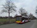
Bus at hashpoint
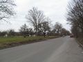
Hashpoint without bus
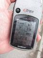
coordinates reached
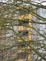
view from hash
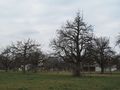
view from hash


Ekorren earned the Déjà Vu Geohash Achievement
|