Difference between revisions of "2014-03-06 48 2"
imported>Dunaril (→Participants) |
imported>FippeBot m (Location) |
||
| (15 intermediate revisions by one other user not shown) | |||
| Line 7: | Line 7: | ||
__NOTOC__ | __NOTOC__ | ||
== Location == | == Location == | ||
| − | On a sidewalk, along a college in the center of Ivry-sur-Seine, Val-de-Marne, Île-de-France, France. Reachable and close the Ivry branch of Metro 7. | + | On a sidewalk, along a college in the center of Ivry-sur-Seine, Val-de-Marne, Île-de-France, France. Reachable and close to the Ivry branch of Metro 7. |
== Participants == | == Participants == | ||
| − | + | Planning to attend, if possible for a first first midnight geohash: [[User:Dunaril|Dunaril]] and finally not [[User:Katu|Katu]]. | |
| − | + | == Expedition == | |
| + | The trip was very boring, not much to tell. After an evening at the theater I hurried with the subway to the geohash position, aiming to be on the spot before midnight. | ||
| − | + | I was there around 23:50. Using roof and trees alignements I could be sure to be on the exact spot, although my phone GPS never got closer than 2m from GZ. | |
| − | |||
| − | |||
| − | |||
| − | |||
| − | |||
| − | + | I tried uploading a few pics with coords and timestamps but GeohashDroid couldn't seem to manage to do this. | |
| − | |||
| − | |||
| + | At midnight I took a few more screenshots and happily moved on to my next target: a [http://www.geocaching.com/geocache/GC2FGPZ_leglise-divry geocache] within a few hundred meters of the hash. Unfortunately I couldn't find it in the limited time I had before the last subway. I rushed to another cache a bit further and got to log it, securing an honorable mention for the hash collision ribbon. | ||
| − | |||
| − | + | *I'm in place -- [[User:Dunaril|Dunaril]] ([[User talk:Dunaril|talk]]) [http://www.openstreetmap.org/?lat=48.81541809&lon=2.38098942&zoom=16&layers=B000FTF @48.8154,2.3810] 23:56, 5 March 2014 (CEST) | |
| − | [[ | ||
| − | |||
| − | [[ | ||
| − | |||
| − | |||
| − | |||
| − | |||
| − | |||
| − | |||
| − | + | *Done! -- [[User:Dunaril|Dunaril]] ([[User talk:Dunaril|talk]]) [http://www.openstreetmap.org/?lat=48.81539927&lon=2.38104159&zoom=16&layers=B000FTF @48.8154,2.3810] 00:00, 6 March 2014 (CEST) | |
| − | [[ | ||
| − | |||
| − | |||
| − | [[ | ||
| − | |||
| − | |||
| − | [ | ||
| − | + | == Photos == | |
| − | [[ | + | <gallery perrow="5"> |
| − | + | Image:2014-03-06-48-2-grim.jpg | Grim at Ground Zero. Notice the tree and corrugated iron roof that match satellite images. | |
| − | + | Image:2014-03-06-48-2-map-before.png | Map screenshot before midnight | |
| − | [[ | + | Image:2014-03-06-48-2-map-after.png | Map screenshot after midnight |
| + | Image:2014-03-06-48-2-radar-before.png | Radar screenshot before midnight | ||
| + | Image:2014-03-06-48-2-radar-after.png | Radar screenshot after midnight | ||
| + | Image:2014-03-06-48-2-cache-log.jpg | The log of geocache http://www.geocaching.com/geocache/GC2FGPZ_leglise-divry | ||
| + | </gallery> | ||
| + | |||
| + | == Achievements == | ||
| + | {{#vardefine:ribbonwidth|800px}} | ||
| + | {{land geohash | ||
| + | | latitude = 48 | ||
| + | | longitude = 2 | ||
| + | | date = 2014-03-06 | ||
| + | | name = [[User:Dunaril|Dunaril]] | ||
| + | }} | ||
| + | {{Midnight geohash | ||
| + | | latitude = 48 | ||
| + | | longitude = 2 | ||
| + | | date = 2014-03-06 | ||
| + | | name = [[User:Dunaril|Dunaril]] | ||
| + | | image = 2014-03-06-48-2-grim.jpg | ||
| + | }} | ||
| + | {{Hash collision | ||
| + | | latitude = 48 | ||
| + | | longitude = 2 | ||
| + | | date = 2014-03-06 | ||
| + | | name = [[User:Dunaril|Dunaril]] | ||
| + | | link = http://www.geocaching.com/geocache/GC2FGPZ | ||
| + | | id = GC2FGPZ | ||
| + | | distance = 0.5 km | ||
| + | | honor = jolly good! | ||
| + | | image = 2014-03-06-48-2-cache-log.jpg | ||
| + | }} | ||
| − | + | [[Category:Expeditions]] | |
| + | [[Category:Expeditions with photos]] | ||
| + | [[Category:Coordinates reached]] | ||
| + | {{location|FR|94}} | ||
Latest revision as of 00:05, 7 August 2019
| Thu 6 Mar 2014 in 48,2: 48.8153834, 2.3810186 geohashing.info google osm bing/os kml crox |
Location
On a sidewalk, along a college in the center of Ivry-sur-Seine, Val-de-Marne, Île-de-France, France. Reachable and close to the Ivry branch of Metro 7.
Participants
Planning to attend, if possible for a first first midnight geohash: Dunaril and finally not Katu.
Expedition
The trip was very boring, not much to tell. After an evening at the theater I hurried with the subway to the geohash position, aiming to be on the spot before midnight.
I was there around 23:50. Using roof and trees alignements I could be sure to be on the exact spot, although my phone GPS never got closer than 2m from GZ.
I tried uploading a few pics with coords and timestamps but GeohashDroid couldn't seem to manage to do this.
At midnight I took a few more screenshots and happily moved on to my next target: a geocache within a few hundred meters of the hash. Unfortunately I couldn't find it in the limited time I had before the last subway. I rushed to another cache a bit further and got to log it, securing an honorable mention for the hash collision ribbon.
- I'm in place -- Dunaril (talk) @48.8154,2.3810 23:56, 5 March 2014 (CEST)
- Done! -- Dunaril (talk) @48.8154,2.3810 00:00, 6 March 2014 (CEST)
Photos

Grim at Ground Zero. Notice the tree and corrugated iron roof that match satellite images.
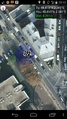
Map screenshot before midnight
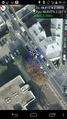
Map screenshot after midnight
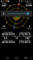
Radar screenshot before midnight
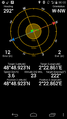
Radar screenshot after midnight
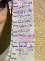
The log of geocache http://www.geocaching.com/geocache/GC2FGPZ_leglise-divry


Achievements
Dunaril earned the Land geohash achievement
|
Dunaril earned the Midnight Geohash achievement
|
Dunaril earned the Hash collision honorable mention
|