Difference between revisions of "2014-03-08 54 -2"
imported>Angel ([live picture] I'm sure there used to be a stile and bridge here [http://www.openstreetmap.org/?lat=54.04630000&lon=-2.85044000&zoom=16&layers=B000FTF @54.0463,-2.8504]) |
imported>FippeBot m (Location) |
||
| (7 intermediate revisions by 2 users not shown) | |||
| Line 1: | Line 1: | ||
| − | |||
| − | |||
| − | |||
| − | |||
| − | |||
| − | |||
| − | |||
| − | |||
| − | |||
{{meetup graticule | {{meetup graticule | ||
| lat=54 | | lat=54 | ||
| Line 15: | Line 6: | ||
}} | }} | ||
| − | + | ||
__NOTOC__ | __NOTOC__ | ||
== Location == | == Location == | ||
| − | + | In a field, near the Golden Ball at Snatchem | |
== Participants == | == Participants == | ||
| − | + | [[User:Angel|Angel]]. One of my flatmates also setout with me, but turned back feeling ill. | |
| − | |||
== Plans == | == Plans == | ||
| − | + | Walk to the Golden Ball, have a pint, and then continue some time around 4 to see if the hash is reachable, and if anyone else is there. | |
== Expedition == | == Expedition == | ||
| − | + | Pretty much as planned. It turned out the footpath didn't go across the field like I thought (the footpath was across the ''next'' field, and was blocked). But it was possible to get into the field through a gate on the far side. I'm not sure if this should have been a "no trespassing", but as the gate wasn't locked and there were enough footprints to suggest that at least a few people walk their dogs across the field, I assume it's effectively public. | |
== Tracklog == | == Tracklog == | ||
| − | + | * [http://www.endomondo.com/workouts/305398648/3871875 First attempt] | |
| + | * [http://www.endomondo.com/workouts/305479214/3871875 Actually made it] | ||
== Photos == | == Photos == | ||
| − | + | ||
| − | |||
| − | |||
<gallery perrow="5"> | <gallery perrow="5"> | ||
Image:2014-03-08_54_-2_13-16-22-114.jpg | Looks like it should be reachable :-) | Image:2014-03-08_54_-2_13-16-22-114.jpg | Looks like it should be reachable :-) | ||
| − | |||
Image:2014-03-08_54_-2_14-41-03-773.jpg | A great place to meet up after reaching the hash (if we can); but not quite there yet. [http://www.openstreetmap.org/?lat=54.04770000&lon=-2.84188000&zoom=16&layers=B000FTF @54.0477,-2.8419] | Image:2014-03-08_54_-2_14-41-03-773.jpg | A great place to meet up after reaching the hash (if we can); but not quite there yet. [http://www.openstreetmap.org/?lat=54.04770000&lon=-2.84188000&zoom=16&layers=B000FTF @54.0477,-2.8419] | ||
| − | |||
Image:2014-03-08_54_-2_14-47-38-266.jpg | Looks promising ... [http://www.openstreetmap.org/?lat=54.04520000&lon=-2.84798000&zoom=16&layers=B000FTF @54.0452,-2.8480] | Image:2014-03-08_54_-2_14-47-38-266.jpg | Looks promising ... [http://www.openstreetmap.org/?lat=54.04520000&lon=-2.84798000&zoom=16&layers=B000FTF @54.0452,-2.8480] | ||
| − | |||
Image:2014-03-08_54_-2_15-04-30-083.jpg | I'm sure there used to be a stile and bridge here [http://www.openstreetmap.org/?lat=54.04630000&lon=-2.85044000&zoom=16&layers=B000FTF @54.0463,-2.8504] | Image:2014-03-08_54_-2_15-04-30-083.jpg | I'm sure there used to be a stile and bridge here [http://www.openstreetmap.org/?lat=54.04630000&lon=-2.85044000&zoom=16&layers=B000FTF @54.0463,-2.8504] | ||
| + | Image:2014-03-08_54_-2_15-58-57-781.jpg | From the lay-by at the side of the road ... Getting closer | ||
| + | Image:2014-03-08_54_-2_16-04-29-799.jpg | Yay! [http://www.openstreetmap.org/?lat=54.04690772&lon=-2.84952156&zoom=16&layers=B000FTF @54.0469,-2.8495] | ||
| + | Image:2014-03-08_54_-2_16-10-41-045.jpg | View from the hash (1) [http://www.openstreetmap.org/?lat=54.04680000&lon=-2.84952000&zoom=16&layers=B000FTF @54.0468,-2.8495] | ||
| + | Image:2014-03-08_54_-2_16-11-49-876.jpg | View from the hash (2) [http://www.openstreetmap.org/?lat=54.04680000&lon=-2.84952000&zoom=16&layers=B000FTF @54.0468,-2.8495] | ||
| + | Image:2014-03-08_54_-2_16-14-57-242.jpg | View from the hash (3) ... How hard do you think it would be for someone on a real computer to stitch these images into a 360 degree panorama? [http://www.openstreetmap.org/?lat=54.04680000&lon=-2.84952000&zoom=16&layers=B000FTF @54.0468,-2.8495] | ||
</gallery> | </gallery> | ||
== Achievements == | == Achievements == | ||
{{#vardefine:ribbonwidth|800px}} | {{#vardefine:ribbonwidth|800px}} | ||
| − | + | {{land geohash | |
| + | | latitude = 54 | ||
| + | | longitude = -2 | ||
| + | | date = 2014-03-08 | ||
| + | | name = Angel | ||
| + | | image = 2014-03-08_54_-2_16-04-29-799.jpg | ||
| + | }} | ||
| − | |||
| − | |||
| − | |||
| − | + | [[Category:Expeditions]] | |
| − | |||
| − | |||
| − | |||
| − | [[Category: | ||
| − | |||
| − | + | [[Category:Expeditions with photos]] | |
| − | |||
| − | |||
| − | [[Category:Expeditions with photos]] | ||
| − | |||
| − | |||
| − | |||
| − | |||
| − | |||
[[Category:Coordinates reached]] | [[Category:Coordinates reached]] | ||
| − | + | {{location|GB|ENG|LAN}} | |
| − | |||
| − | |||
| − | |||
| − | |||
| − | |||
| − | |||
| − | |||
| − | |||
| − | |||
| − | |||
| − | |||
| − | |||
| − | |||
| − | |||
| − | |||
| − | |||
| − | |||
Latest revision as of 05:49, 14 August 2019
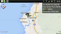
| Sat 8 Mar 2014 in 54,-2: 54.0468698, -2.8495280 geohashing.info google osm bing/os kml crox |
Location
In a field, near the Golden Ball at Snatchem
Participants
Angel. One of my flatmates also setout with me, but turned back feeling ill.
Plans
Walk to the Golden Ball, have a pint, and then continue some time around 4 to see if the hash is reachable, and if anyone else is there.
Expedition
Pretty much as planned. It turned out the footpath didn't go across the field like I thought (the footpath was across the next field, and was blocked). But it was possible to get into the field through a gate on the far side. I'm not sure if this should have been a "no trespassing", but as the gate wasn't locked and there were enough footprints to suggest that at least a few people walk their dogs across the field, I assume it's effectively public.
Tracklog
Photos
Looks like it should be reachable :-)
A great place to meet up after reaching the hash (if we can); but not quite there yet. @54.0477,-2.8419
Looks promising ... @54.0452,-2.8480
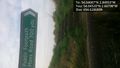
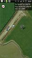
I'm sure there used to be a stile and bridge here @54.0463,-2.8504
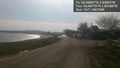
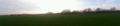
From the lay-by at the side of the road ... Getting closer
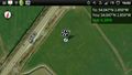
Yay! @54.0469,-2.8495
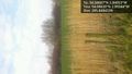
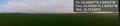
View from the hash (1) @54.0468,-2.8495

View from the hash (2) @54.0468,-2.8495
View from the hash (3) ... How hard do you think it would be for someone on a real computer to stitch these images into a 360 degree panorama? @54.0468,-2.8495


Achievements
Angel earned the Land geohash achievement
|