Difference between revisions of "2014-03-13 50 19"
From Geohashing
imported>Mkoniecz (finish report) |
imported>FippeBot m (Location) |
||
| (5 intermediate revisions by one other user not shown) | |||
| Line 1: | Line 1: | ||
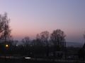
| − | [[Image:2014-03-13 50 19 hash.JPG|thumb|left]] | + | [[Image:2014-03-13 50 19 hash.JPG|thumb|left|400px|Bicycle marks the hashpoint]] |
{{meetup graticule | {{meetup graticule | ||
| Line 12: | Line 12: | ||
== Participants == | == Participants == | ||
| − | [[User: | + | [[User:mkoniecz|mkoniecz]] ([[User talk:mkoniecz|talk]]) |
== Expedition == | == Expedition == | ||
| − | My grandfather lives nearby, so I was able to visit him during the same trip. As it turned out, area was accessible but it will change on near future as fence is under construction. I arrived at hash in the evening, as result photos are awful. | + | My grandfather lives nearby, so I was able to visit him during the same trip. As it turned out, area was accessible but it will change on near future as fence is under construction (it seems to be part of psychiatric hospital after all). I arrived at hash in the evening, as result photos are awful. |
== Photos == | == Photos == | ||
| − | < | + | <gallery perrow="2"> |
Image:Lasek Wolski from 2014-03-13 50 19.JPG | Lasek Wolski, place of [[2014-03-08 50 19]] hash visible in distance | Image:Lasek Wolski from 2014-03-13 50 19.JPG | Lasek Wolski, place of [[2014-03-08 50 19]] hash visible in distance | ||
Image:Unfinished fence at 2014-03-13 50 19.JPG| Fortunately unfinished fence | Image:Unfinished fence at 2014-03-13 50 19.JPG| Fortunately unfinished fence | ||
| − | |||
| − | |||
</gallery> | </gallery> | ||
| Line 31: | Line 29: | ||
| longitude = 19 | | longitude = 19 | ||
| date = 2014-03-13 | | date = 2014-03-13 | ||
| − | | name = [[User: | + | | name = [[User:mkoniecz|mkoniecz]] |
| distance = 24 km | | distance = 24 km | ||
}} | }} | ||
| Line 38: | Line 36: | ||
| longitude = 19 | | longitude = 19 | ||
| date = 2014-03-13 | | date = 2014-03-13 | ||
| − | | name = [[User: | + | | name = [[User:mkoniecz|mkoniecz]] |
}} | }} | ||
{{OpenStreetMap achievement | {{OpenStreetMap achievement | ||
| Line 46: | Line 44: | ||
| OSMlink = 21077612 | | OSMlink = 21077612 | ||
| OSMlink2 = 21131687 | | OSMlink2 = 21131687 | ||
| − | | name = [[User: | + | | name = [[User:mkoniecz|mkoniecz]] |
}} | }} | ||
| Line 54: | Line 52: | ||
[[Category:Expedition without GPS]] | [[Category:Expedition without GPS]] | ||
[[Category:Coordinates reached]] | [[Category:Coordinates reached]] | ||
| + | {{location|PL|K|K}} | ||
Latest revision as of 05:51, 14 August 2019

| Thu 13 Mar 2014 in 50,19: 50.0062920, 19.8875099 geohashing.info google osm bing/os kml crox |
Location
Southern Kraków, psychiatric hospital in Kobierzyn. I was worried that this area also may be part of it and inaccessible.
Participants
Expedition
My grandfather lives nearby, so I was able to visit him during the same trip. As it turned out, area was accessible but it will change on near future as fence is under construction (it seems to be part of psychiatric hospital after all). I arrived at hash in the evening, as result photos are awful.
Photos
Lasek Wolski, place of 2014-03-08 50 19 hash visible in distance
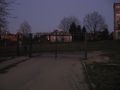
Fortunately unfinished fence


Achievements
mkoniecz earned the Bicycle geohash achievement
|
mkoniecz earned the No Batteries Geohash Achievement
|
mkoniecz earned the OpenStreetMap achievement
|