Difference between revisions of "2014-03-16 48 11"
imported>Zertrin (initialize expedition report) |
imported>Zertrin (Expedition report : Coordinates reached !) |
||
| Line 1: | Line 1: | ||
| − | |||
| − | |||
| − | |||
| − | |||
| − | |||
| − | |||
| − | |||
| − | |||
| − | |||
| − | |||
{{meetup graticule | {{meetup graticule | ||
| lat=48 | | lat=48 | ||
| Line 15: | Line 5: | ||
}} | }} | ||
| − | |||
__NOTOC__ | __NOTOC__ | ||
== Location == | == Location == | ||
| − | + | About 1.2 km south-east of the train station of Mammendorf, on the edge of a field. | |
| + | |||
| + | [[Image:{{{image|2014-03-16_48_11_Zertrin_google_map.png}}}|700px]] | ||
== Participants == | == Participants == | ||
| − | + | [[User:Zertrin|Zertrin]] | |
| − | |||
== Plans == | == Plans == | ||
| − | + | Initial plan was to see if I would get enough motivation in this Sunday to try to reach the hash using only public transportation. | |
== Expedition == | == Expedition == | ||
| − | + | Middle of Sunday afternoon, I just remember that today's hash seemed pretty easy to reach by public transport. I had saved the link of the preliminary public transport planning I made Friday, and by opening it I see that if I went within in 10 minutes I would catch a favorable schedule. Also I grabbed my geohashing's essentials, put my coat on and ran a bit along the way to catch the S-Bahn in time. | |
| + | |||
| + | The rest of the trip was pretty uneventful, the S-Bahn arrived a bit late but I managed to get into the regional train in time before its departure. Mammendorf being only the second stop of the train, the travel was short. The walk to the hash went smoothly, with the only exception being that the beginning of the track I planned to take to reach the hash had been buried by excavated dirt from a apparently new area to store containers (see pictures below). | ||
| + | |||
| + | The hash lay in the field within 2 meters from the edge, and was reached at 5:37 p.m. Fortunately the dirt was dry this time, and the crops were sparse and scattered enough to be able to avoid walking on any of them. I took the usual proofs and a panoramic view from near the hashpoint, and then headed back to the train station, hoping for a fortunate connection, because I hadn't planned at all the return trip. | ||
| + | |||
| + | While walking back to the station, I checked the app for the public transportation and it appeared that a train was departing in 10 minutes. By hurrying up a bit I made it just in time \o/. The next one being 40 minutes later, I was quite happy to catch this one. | ||
| + | |||
| + | The way back went uneventful. | ||
== Tracklog == | == Tracklog == | ||
| − | + | http://www.everytrail.com/view_trip.php?trip_id=2703264 | |
== Photos == | == Photos == | ||
| − | |||
| − | |||
| − | |||
<gallery perrow="5"> | <gallery perrow="5"> | ||
| + | Image:2014-03-16_48_11_Zertrin_google_route.png | Don't like all of the new features of the new GMaps but planning public transportation is a breeze now. | ||
| + | Image:2014-03-16_48_11_Zertrin_Arrival_at_Mammendorf.JPG | Arrival at Mammendorf train station | ||
| + | Image:2014-03-16_48_11_Zertrin_google_map.png | Itinerary from the train station to the hash. | ||
| + | Image:2014-03-16_48_11_Zertrin_Path1.JPG | The beginning of the track has been destroyed by recent works. | ||
| + | Image:2014-03-16_48_11_Zertrin_Path2.JPG | The initial path is under the dirt. | ||
| + | Image:2014-03-16_48_11_Zertrin_GPS_Coords.png | Coordinates reached! | ||
| + | Image:2014-03-16_48_11_Zertrin_at_the_hashpoint.JPG | [[User:Zertrin|Zertrin]] at the hashpoint | ||
| + | Image:2014-03-16_48_11_Zertrin_The_hashpoint.JPG | The hashpoint | ||
| + | Image:2014-03-16_48_11_Zertrin_ADAC_Bus.JPG | A yellow <strike>submarine</strike> bus | ||
| + | Image:2014-03-16_48_11_Zertrin_Return_S-Bahn.JPG | Just in time to take the S-Bahn for Munich \o/ | ||
</gallery> | </gallery> | ||
| + | |||
| + | And the Panorama -- [http://wiki.xkcd.com/wgh/images/4/4d/2014-03-16_48_11_Zertrin_Panorama.jpg full resolution (8830x1024px - 1.23 MB)] | ||
| + | |||
| + | [[Image:{{{image|2014-03-16_48_11_Zertrin_Panorama.jpg}}}|800px]] | ||
== Achievements == | == Achievements == | ||
{{#vardefine:ribbonwidth|800px}} | {{#vardefine:ribbonwidth|800px}} | ||
| − | + | {{Public transport geohash | latitude = 48 | longitude = 11 | date = 2014-03-16 | busline = the S1, the regional train to Donauwörth, the S3 to Pasing, the tram 19 to St.-Veit-Straße and finally the bus line 51 to Moosach Bf. | name = Zertrin | image = 2014-03-16_48_11_Zertrin_Return_S-Bahn.JPG }} | |
| − | |||
| − | |||
| − | |||
| − | |||
| − | |||
| − | |||
| − | |||
| − | |||
| − | |||
| − | |||
| − | |||
| − | |||
| − | |||
[[Category:Expeditions]] | [[Category:Expeditions]] | ||
| − | |||
[[Category:Expeditions with photos]] | [[Category:Expeditions with photos]] | ||
| − | |||
| − | |||
| − | |||
| − | |||
| − | |||
[[Category:Coordinates reached]] | [[Category:Coordinates reached]] | ||
| − | |||
| − | |||
| − | |||
| − | |||
| − | |||
| − | |||
| − | |||
| − | |||
| − | |||
| − | |||
| − | |||
| − | |||
| − | |||
| − | |||
| − | |||
| − | |||
| − | |||
| − | |||
Revision as of 19:06, 16 March 2014
| Sun 16 Mar 2014 in 48,11: 48.2119265, 11.1802563 geohashing.info google osm bing/os kml crox |
Location
About 1.2 km south-east of the train station of Mammendorf, on the edge of a field.

Participants
Plans
Initial plan was to see if I would get enough motivation in this Sunday to try to reach the hash using only public transportation.
Expedition
Middle of Sunday afternoon, I just remember that today's hash seemed pretty easy to reach by public transport. I had saved the link of the preliminary public transport planning I made Friday, and by opening it I see that if I went within in 10 minutes I would catch a favorable schedule. Also I grabbed my geohashing's essentials, put my coat on and ran a bit along the way to catch the S-Bahn in time.
The rest of the trip was pretty uneventful, the S-Bahn arrived a bit late but I managed to get into the regional train in time before its departure. Mammendorf being only the second stop of the train, the travel was short. The walk to the hash went smoothly, with the only exception being that the beginning of the track I planned to take to reach the hash had been buried by excavated dirt from a apparently new area to store containers (see pictures below).
The hash lay in the field within 2 meters from the edge, and was reached at 5:37 p.m. Fortunately the dirt was dry this time, and the crops were sparse and scattered enough to be able to avoid walking on any of them. I took the usual proofs and a panoramic view from near the hashpoint, and then headed back to the train station, hoping for a fortunate connection, because I hadn't planned at all the return trip.
While walking back to the station, I checked the app for the public transportation and it appeared that a train was departing in 10 minutes. By hurrying up a bit I made it just in time \o/. The next one being 40 minutes later, I was quite happy to catch this one.
The way back went uneventful.
Tracklog
http://www.everytrail.com/view_trip.php?trip_id=2703264
Photos
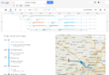
Don't like all of the new features of the new GMaps but planning public transportation is a breeze now.
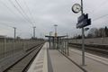
Arrival at Mammendorf train station
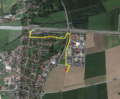
Itinerary from the train station to the hash.
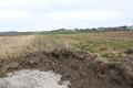
The beginning of the track has been destroyed by recent works.
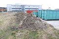
The initial path is under the dirt.
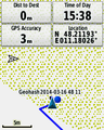
Coordinates reached!

Zertrin at the hashpoint
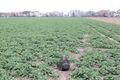
The hashpoint
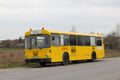
A yellow
submarinebus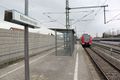
Just in time to take the S-Bahn for Munich \o/


And the Panorama -- full resolution (8830x1024px - 1.23 MB)

Achievements
Zertrin earned the Public transport geohash achievement
|