Difference between revisions of "2014-03-18 49 8"
From Geohashing
imported>Snoopy ([live] at 11a.m. arrive at my first geohash. direct b35 between helmsheim and gondelsheim) |
imported>FippeBot m (Location) |
||
| (8 intermediate revisions by 2 users not shown) | |||
| Line 19: | Line 19: | ||
== Location == | == Location == | ||
<!-- where you've surveyed the hash to be --> | <!-- where you've surveyed the hash to be --> | ||
| + | b35 near heidelsheim | ||
| + | 49.0826459, 8.6499926 | ||
== Participants == | == Participants == | ||
<!-- who attended: If you link to your wiki user name in this section, your expedition will be picked up by the various statistics generated for geohashing. You may use three tildes ~ as a shortcut to automatically insert the user signature of the account you are editing with. | <!-- who attended: If you link to your wiki user name in this section, your expedition will be picked up by the various statistics generated for geohashing. You may use three tildes ~ as a shortcut to automatically insert the user signature of the account you are editing with. | ||
--> | --> | ||
| + | [[User:Snoopy|Snoopy]] | ||
== Plans == | == Plans == | ||
| Line 30: | Line 33: | ||
== Expedition == | == Expedition == | ||
<!-- how it all turned out. your narrative goes here. --> | <!-- how it all turned out. your narrative goes here. --> | ||
| − | |||
*at 11a.m. arrive at my first geohash. direct b35 between helmsheim and gondelsheim -- [[User:Snoopy|Snoopy]] ([[User talk:Snoopy|talk]]) [http://www.openstreetmap.org/?lat=49.08242916&lon=8.65014092&zoom=16&layers=B000FTF @49.0824,8.6501] 06:01, 18 March 2014 (EDT) | *at 11a.m. arrive at my first geohash. direct b35 between helmsheim and gondelsheim -- [[User:Snoopy|Snoopy]] ([[User talk:Snoopy|talk]]) [http://www.openstreetmap.org/?lat=49.08242916&lon=8.65014092&zoom=16&layers=B000FTF @49.0824,8.6501] 06:01, 18 March 2014 (EDT) | ||
| Line 41: | Line 43: | ||
--> | --> | ||
<gallery perrow="5"> | <gallery perrow="5"> | ||
| + | |||
| + | Image:2014-03-18_49_8_11-02-12-517.jpg | | ||
| + | |||
| + | Image:2014-03-18_49_8_11-03-29-075.jpg | | ||
| + | |||
| + | Image:2014-03-18_49_8_11-23-25-173.jpg | Vesperpause in gondelsheim | ||
| + | |||
| + | Image:2014-03-18_49_8_23-38-04-800.jpg | ordentliche Radtour | ||
</gallery> | </gallery> | ||
| Line 48: | Line 58: | ||
| − | <!-- =============== USEFUL CATEGORIES FOLLOW ================ | + | <!-- =============== USEFUL CATEGORIES FOLLOW ================ --> |
| − | |||
| − | |||
| − | |||
| − | |||
| − | |||
| − | |||
| − | |||
| − | |||
| − | |||
| − | |||
[[Category:Expeditions]] | [[Category:Expeditions]] | ||
| − | |||
[[Category:Expeditions with photos]] | [[Category:Expeditions with photos]] | ||
| − | |||
| − | |||
| − | |||
| − | |||
| − | |||
[[Category:Coordinates reached]] | [[Category:Coordinates reached]] | ||
| − | + | {{location|DE|BW|KA}} | |
| − | |||
| − | |||
| − | |||
| − | |||
| − | |||
| − | |||
| − | |||
| − | |||
| − | |||
| − | |||
| − | |||
| − | |||
| − | |||
| − | |||
| − | |||
| − | |||
| − | |||
Latest revision as of 05:56, 14 August 2019
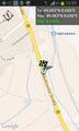
| Tue 18 Mar 2014 in 49,8: 49.0826459, 8.6499926 geohashing.info google osm bing/os kml crox |
Location
b35 near heidelsheim 49.0826459, 8.6499926
Participants
Plans
Well, I plan tommorow my first geohash in heidelsheim. -- Snoopy (talk) 11:28, 17 March 2014 (EDT)
Expedition
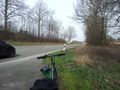
- at 11a.m. arrive at my first geohash. direct b35 between helmsheim and gondelsheim -- Snoopy (talk) @49.0824,8.6501 06:01, 18 March 2014 (EDT)
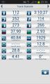
Tracklog
Photos
Vesperpause in gondelsheim
ordentliche Radtour


