Difference between revisions of "2014-03-29 49 8"
From Geohashing
imported>Q-Owl (Created page with "<!-- If you did not specify these parameters in the template, please substitute appropriate values for IMAGE, LAT, LON, and DATE (YYYY-MM-DD format) Image:{{{image|IMAGE}}...") |
imported>Q-Owl |
||
| Line 32: | Line 32: | ||
== Photos == | == Photos == | ||
| − | |||
| − | |||
<gallery> | <gallery> | ||
| − | Image: | + | Image:20140329_1831-kl.jpg | On the ferry over the Rhine to Nierstein |
| − | Image: | + | Image:Screenshot_2014-03-29-18-50-kl.jpg| Screenshot (Smartphone) |
</gallery> | </gallery> | ||
| + | |||
| + | <!-- | ||
<gallery> | <gallery> | ||
| + | |||
Image:20131211 north.jpg | View to North | Image:20131211 north.jpg | View to North | ||
Image:20131211 south.jpg | View to South | Image:20131211 south.jpg | View to South | ||
Revision as of 20:09, 29 March 2014
| Sat 29 Mar 2014 in 49,8: 49.8630715, 8.3375972 geohashing.info google osm bing/os kml crox |
Location
The hashpoint is located near Nierstein not far from the Rhine.
Participants
Plan
I had the plan to find some geocaches, but doing that I thougt I schuld not pass up the opportunity to get to todays hashpoint; my first this year.
Expedition
.........
Photos
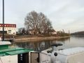
On the ferry over the Rhine to Nierstein
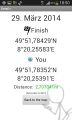
Screenshot (Smartphone)


Achievements / Honorable Mention
Q-Owl earned the Land geohash achievement
|