Difference between revisions of "2014-04-11 54 8"
imported>Yakamoz (→Achievements) |
imported>FippeBot m (Location) |
||
| (13 intermediate revisions by 2 users not shown) | |||
| Line 25: | Line 25: | ||
== Plans == | == Plans == | ||
| − | + | This was an unplanned geohash. We made an excursion to Westerhever lighthouse. Since we didn't get very near due to a seasonal path closure to protect the wild geeses' recreation habitat, we needed another use for our outdoors time. Hence, we drove spontaneously to the next geohash point. | |
== Expedition == | == Expedition == | ||
| − | + | We went there by car, the last two hundred meters we went by foot. The geohash point looked like pasture ground, also baaah-ing was to be heard from other pastures in its neighbourhood. We caught the coordinates as well as possible and drove back to Sankt Peter Ording where we were staying for our holiday. | |
== Tracklog == | == Tracklog == | ||
| Line 40: | Line 40: | ||
Image:2014-04-11_54_8_20-57-11-936.jpg | Coordinates reached | Image:2014-04-11_54_8_20-57-11-936.jpg | Coordinates reached | ||
| + | |||
| + | Image:2014-04-11_54_8_yakamoz_1397248680000.jpg | successful mission | ||
| + | |||
| + | Image:2014-04-11_54_8_yakamoz_1397248284000.jpg | Around the geohash point | ||
| + | |||
| + | Image:2014-04-11_54_8_yakamoz_1397248208000.jpg | Geohash pasture | ||
</gallery> | </gallery> | ||
| Line 45: | Line 51: | ||
{{#vardefine:ribbonwidth|800px}} | {{#vardefine:ribbonwidth|800px}} | ||
{{Land geohash | {{Land geohash | ||
| − | | latitude = 54 | + | | latitude = 54 |
| longitude = 8 | | longitude = 8 | ||
| date = 2014-04-11 | | date = 2014-04-11 | ||
| Line 51: | Line 57: | ||
}} | }} | ||
| − | }} | + | {{#vardefine:ribbonwidth|800px}} |
| + | {{Land geohash | ||
| + | | latitude = 54 | ||
| + | | longitude = 8 | ||
| + | | date = 2014-04-11 | ||
| + | | name = [[User:Yakamoz|Yakamoz]] | ||
| + | }} | ||
[[Category:Expeditions]] | [[Category:Expeditions]] | ||
[[Category:Expeditions with photos]] | [[Category:Expeditions with photos]] | ||
[[Category:Coordinates reached]] | [[Category:Coordinates reached]] | ||
| − | + | {{location|DE|SH|HEI}} | |
| − | |||
Latest revision as of 00:10, 7 August 2019
| Fri 11 Apr 2014 in 54,8: 54.2212586, 8.9949321 geohashing.info google osm bing/os kml crox |
Location
On a field near Neuenkirchen (Schleswig-Holstein, the North Sea area).
Participants
Plans
This was an unplanned geohash. We made an excursion to Westerhever lighthouse. Since we didn't get very near due to a seasonal path closure to protect the wild geeses' recreation habitat, we needed another use for our outdoors time. Hence, we drove spontaneously to the next geohash point.
Expedition
We went there by car, the last two hundred meters we went by foot. The geohash point looked like pasture ground, also baaah-ing was to be heard from other pastures in its neighbourhood. We caught the coordinates as well as possible and drove back to Sankt Peter Ording where we were staying for our holiday.
Tracklog
Photos
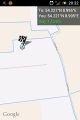
Coordinates reached
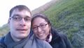
successful mission
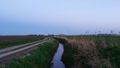
Around the geohash point
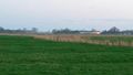
Geohash pasture


Achievements
Rincewind earned the Land geohash achievement
|
Yakamoz earned the Land geohash achievement
|