Difference between revisions of "2014-04-13 53 9"
imported>Yakamoz ([retro picture] Geohash point) |
imported>FippeBot m (Location) |
||
| (3 intermediate revisions by 2 users not shown) | |||
| Line 27: | Line 27: | ||
== Expedition == | == Expedition == | ||
| − | As planned, we went back | + | As planned, we went back some 700km by car and wanted to use this opportunity to visit a new geohash graticul, if the coordinates are convenient. In this case, that meant near Autobahn 23 or 7 and it worked out. Hence, we went past the village Wintermoor. The geohash point was easy to reach, directly off a highway. When we arrived, the GPS showed 17 m distance. We got out, did a few steps and already - coordinates reached! After the geohash dance and some photos we drove on. |
| + | The building was on a rather big agricultural complex and seemed to be a silo of some sort, potentially a biogas plant, as another one of similar dimensions was just opposite. | ||
== Tracklog == | == Tracklog == | ||
| Line 40: | Line 41: | ||
Image:2014-04-13_53_9_yakamoz_1397397213000.jpg | Geohash point | Image:2014-04-13_53_9_yakamoz_1397397213000.jpg | Geohash point | ||
| + | |||
| + | Image:2014-04-13_53_9_yakamoz_1397397102000.jpg | Geohash dance | ||
| + | |||
| + | Image:2014-04-13_53_9_yakamoz_1397397119000.jpg | Geohash oafishness | ||
</gallery> | </gallery> | ||
| Line 62: | Line 67: | ||
[[Category:Expeditions with photos]] | [[Category:Expeditions with photos]] | ||
[[Category:Coordinates reached]] | [[Category:Coordinates reached]] | ||
| + | {{location|DE|NI|HK}} | ||
Latest revision as of 06:10, 14 August 2019
| Sun 13 Apr 2014 in 53,9: 53.1709859, 9.8159831 geohashing.info google osm bing/os kml crox |
Location
In the area of some agricultural building, probably a biogas plant (Wintermoor, Lower Saxony).
Participants
Plans
To catch a new graticule on the home way from Sankt Peter Ording to Hesse
Expedition
As planned, we went back some 700km by car and wanted to use this opportunity to visit a new geohash graticul, if the coordinates are convenient. In this case, that meant near Autobahn 23 or 7 and it worked out. Hence, we went past the village Wintermoor. The geohash point was easy to reach, directly off a highway. When we arrived, the GPS showed 17 m distance. We got out, did a few steps and already - coordinates reached! After the geohash dance and some photos we drove on. The building was on a rather big agricultural complex and seemed to be a silo of some sort, potentially a biogas plant, as another one of similar dimensions was just opposite.
Tracklog
Photos
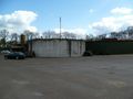
Geohash point
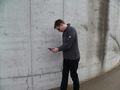
Geohash dance

Geohash oafishness


Achievements
Rincewind earned the Land geohash achievement
|
Yakamoz earned the Land geohash achievement
|