Difference between revisions of "2014-04-20 49 8"
imported>Yakamoz ([live picture] Hashgrin...) |
|||
| (37 intermediate revisions by 6 users not shown) | |||
| Line 1: | Line 1: | ||
| − | |||
| − | |||
| − | |||
| − | |||
| − | |||
| − | |||
| − | |||
| − | |||
| − | |||
| − | |||
{{meetup graticule | {{meetup graticule | ||
| lat=49 | | lat=49 | ||
| lon=8 | | lon=8 | ||
| date=2014-04-20 | | date=2014-04-20 | ||
| − | }} | + | }}__NOTOC__ |
| + | == Location == | ||
| + | |||
| + | On a track on top of the flood protection levee at Biebesheim. | ||
| − | |||
| − | |||
| − | |||
| − | |||
| − | |||
== Participants == | == Participants == | ||
| − | + | * [[User:DODO|DODO]] at 10:30 a.m. | |
| − | + | * [[User:Danatar|Danatar]] at 4 p.m. | |
| − | [[User: | + | * [[User:Rincewind|Rincewind]] and [[User:Yakamoz|Yakamoz]] at 6 p.m. |
| + | * [[User:Q-Owl|Q-Owl]] at 9 p.m. | ||
== Plans == | == Plans == | ||
| − | + | ===DODO=== | |
To catch the train at 9:02 in Speyer, arrive in Gernsheim at 10:07, ride to the hash on my bicycle and ride on to Groß Gerau. Catch the train there at 11:55 and drive to Neuwied, where I'll visit my mother, before I cycle from hash to hash the following three days. | To catch the train at 9:02 in Speyer, arrive in Gernsheim at 10:07, ride to the hash on my bicycle and ride on to Groß Gerau. Catch the train there at 11:55 and drive to Neuwied, where I'll visit my mother, before I cycle from hash to hash the following three days. | ||
| − | == | + | === Q-Owl === |
| − | + | We had an easter family meeting and for a long time I did not know whether or when I could visit the hashpoint. | |
| − | |||
| − | == | + | == Expeditions == |
| − | + | ===DODO=== | |
| + | [[2014-04-18_49_8|previous]] [[2014-04-21 50 8|next]] | ||
| − | == Photos == | + | So I don't have to write very much, as my post writers already did tell most of the things, I could tell. |
| − | < | + | I got all the trains to Gernsheim as planned and after a short ride through an ugly industrial area I reached the rhine dike at Biebesheim where I easily found the hashpoint and left a chalk mark (and I was very pleased to read, that someone else found it). The weather was great and I wanted to take pictures of every stork, donkey and the natural reservate Kühkopf, but I had to catch another train and so I must hurry a little bit. I reached the station in Groß Gerau just 10 minutes before the trains departure. This train was 6 minutes late when it arrived at Wiesbaden - very much time when you have 8 minutes to change trains.But whith a little sprint I reached the next train just in time and reached my mothers home at 3 pm. |
| − | + | ||
| − | --> | + | Next station on my journey was [[2014-04-21_50_8]]. |
| + | |||
| + | ===Danatar=== | ||
| + | After visiting my parents, I had to get back to Würzburg for night duty on Easter Sunday. The hashpoints were conveniently placed so that I planned to visit two of them without too much of a detour. The first one was 2014-04-20 49 8, near the Rhine at Biebesheim. First I drove to the Autobahn A659, changing to the A6 and A67 after a short time. I left the last one at the Gernsheim exit, driving to Gernsheim. At that time the first of many motorcyclists for the day crossed my path, doing wheelies behind me. At 15:40 I arrived at Biebesheim, parking the car in a parking lot next to the flood protection levee. From there I walked along the Rhine, then followed the levee when it turned away from the river towards the hashpoint. It was a nice walk in the sunshine. The hashpoint was on top of the levee in a place where multiple tracks crossed. My GPS unit located the spot about 2 meters away from DODO’s chalk marks, around 4 p.m.. While I was taking the pictures, a couple with a dog arrived and rested at the bench next to the hashpoint. I saw lots of storks flying around or walking across the meadows, a sign nearby informing me that at Biebesheim there’s an important location for storks, with more than 50 breeding pairs. Then I walked back to my car. I drove via Pfungstadt to the Odenwald, cruising towards the [[2014-04-20 49 9|49 9]] hashpoint. | ||
| + | |||
| + | |||
| + | === Rincewind & Yakamoz=== | ||
| + | We celebrated Easter Sunday with Rincewind's family with a lavish Asian buffet lunch, paschal lamb cake and chocolate easter bunnies. Afterwards, it was high time we went geohashing. The nearest coordinates were in Biebesheim, 19 km away from home. It was very easy to reach. When we walked back, we almost walked through it, without noticing the handwriting on the ground, but Rincewind still spotted it: An XKCD logo and the link written in chalk... Rincewind supposed DODO could have been there before us. He's right, is he not?... | ||
| + | |||
| + | |||
| + | ===Q-Owl=== | ||
| + | After most members of the family had left, the others wanted to watch "Horsewhisperer" on TV, but I needed some time out. So (without having a look at the wiki) I drove to [[wikipedia:Biebesheim|Biebesheim]] arriving at 21:30. | ||
| + | I found the hashpoint quickly and made the first photos. | ||
| + | |||
| + | But oops! There was some chalk writing on the bike path. *ggg* Very nice to see this kind of greeting, confirming that I am not the only geohash freak in this area. ;-) | ||
| + | |||
| + | After that I looked for the geocache [http://www.geocaching.com/geocache/GC2RRTR_die-nonne-von-katzenelnbogen GC2RRTR]. Not easy in the darkness. | ||
| + | |||
| + | |||
| + | == Photos== | ||
| + | ===DODO=== | ||
| + | <gallery> | ||
| + | File:2014-04-20 49 8-DODO1.jpg|bike near the hash | ||
| + | File:2014-04-20 49 8-DODO2.jpg|proof | ||
| + | File:2014-04-20 49 8-DODO3.jpg|some easter eggs | ||
| + | File:2014-04-20 49 8-DODO4.jpg|grinning | ||
| + | File:2014-04-20 49 8-DODO5.jpg|the first photo of the chalk mark | ||
| + | File:2014-04-20 49 8-DODO8.jpg|one stork photo (I can't resist) | ||
| + | File:2014-04-20 49 8-DODO6.jpg|Kühkopf | ||
| + | File:2014-04-20 49 8-DODO7.jpg|river rhine seen from the train | ||
| + | </gallery> | ||
| + | |||
| + | ===Danatar=== | ||
| + | <gallery> | ||
| + | File:2014-04-20_49_8_da_rhein.jpg|the Rhine | ||
| + | File:2014-04-20_49_8_da_deich.jpg|walking along the levee | ||
| + | File:2014-04-20_49_8_da_gps.jpg|GPS, chalk marker in the background | ||
| + | File:2014-04-20_49_8_da_hp.jpg|coordinates reached | ||
| + | File:2014-04-20_49_8_da_pano.jpg|panorama | ||
| + | File:2014-04-20_49_8_da_marker.jpg| | ||
| + | File:2014-04-20_49_8_da_hund.jpg|hashdog | ||
| + | File:2014-04-20_49_8_da_vogelpark.jpg| | ||
| + | File:2014-04-20_49_8_da_storch.jpg|storks | ||
| + | </gallery> | ||
| + | |||
| + | |||
| + | ===Rincewind & Yakamoz=== | ||
<gallery perrow="5"> | <gallery perrow="5"> | ||
| + | Image:2014-04-20_49_8_yakamoz_1398021169000.jpg | Coordinates reached | ||
| + | |||
| + | Image:2014-04-20_49_8_yakamoz_1398021165000.jpg | Hashgrin... | ||
| + | |||
| + | Image:2014-04-20_49_8_yakamoz_-1.jpg | Discovery on the road | ||
| + | </gallery> | ||
| − | |||
| − | Image: | + | ===Q-Owl=== |
| + | <gallery perrow="5"> | ||
| + | Image:20140420 2054E-kl.jpg | view east | ||
| + | Image:20140420 2050NE-kl.jpg | view northeast | ||
| + | Image:20140420 2051N-kl.jpg | view north | ||
| + | Image:20140420 2053B-kl.jpg | message on the bottom | ||
| + | Image:20140420 2055G-kl.jpg | grin | ||
| + | Image:20140420 2059storks-kl.jpg| fighting storks | ||
| + | Image:20140420 2110GC-kl.jpg| Geocache | ||
</gallery> | </gallery> | ||
| − | == Achievements == | + | == Achievements / Honorable Mention == |
{{#vardefine:ribbonwidth|800px}} | {{#vardefine:ribbonwidth|800px}} | ||
| − | |||
| + | {{gratuitous ribbon | ||
| + | | icon = Avoid achievement.png | ||
| + | | latitude = 49 | ||
| + | | longitude = 8 | ||
| + | | date = 2014-04-20 | ||
| + | | achievement = Avoid Each Other Achievement | ||
| + | | description = launching four independent expeditions without meeting up at the | ||
| + | | name = [[User:DODO|DODO]], [[User:Danatar|Danatar]], [[User:Rincewind|Rincewind]]&[[User:Yakamoz|Yakamoz]] and [[User:Q-Owl|Q-Owl]] | ||
| + | }} | ||
| + | |||
| + | |||
| + | {{#vardefine:ribbonwidth|700px}} | ||
| + | {{Land geohash | ||
| + | | latitude = 49 | ||
| + | | longitude = 8 | ||
| + | | date = 2014-04-20 | ||
| + | | name = [[User:Rincewind|Rincewind]] and [[User:Yakamoz|Yakamoz]] | ||
| + | }} | ||
| + | |||
| + | |||
| + | {{Land geohash | ||
| + | | latitude = 49 | ||
| + | | longitude = 8 | ||
| + | | date = 2014-04-20 | ||
| + | | name = [[User:Q-Owl|Q-Owl]] | ||
| + | }} | ||
| + | {{Hash collision | latitude = 49 | longitude = 8 | | ||
| + | date = 2014-04-20 | name = Q-Owl | | ||
| + | id = GC2RRTR | link = http://coord.info/GC2RRTR | | ||
| + | distance = 150 meters | honor = yes }} 150 m from the hashpoint, but not in direct sight | ||
| + | |||
| + | |||
| + | Yes, I know, thats boring, but just for completeness: | ||
| + | {{land geohash | ||
| + | |||
| + | | latitude = 49 | ||
| + | | longitude = 8 | ||
| + | | date = 2014-04-20 | ||
| + | | name = DODO | ||
| + | }} | ||
| + | |||
| + | And since I haven't made all the way to the hash on bike, I had to change this into my first | ||
| + | {{Public transport geohash | ||
| + | | latitude = 49 | ||
| + | | longitude = 8 | ||
| + | | date = 2014-04-20 | ||
| + | | name = DODO | ||
| + | }} | ||
| + | |||
| + | ===Tracklogs=== | ||
| + | |||
| + | [http://www.everytrail.com/view_trip.php?trip_id=2747012&code=a7b5099493bfe3d446ecaf4783c79fe9 tracklog for both Danatar's hashpoints] | ||
| + | [http://www.gpsies.com/map.do?fileId=oyebunkpshhrezbh DODOs track: bike 36 KM (in 2 parts), train: 191 KM] | ||
[[Category:Expeditions]] | [[Category:Expeditions]] | ||
[[Category:Expeditions with photos]] | [[Category:Expeditions with photos]] | ||
[[Category:Coordinates reached]] | [[Category:Coordinates reached]] | ||
| + | {{location|DE|HE|GG}} | ||
Latest revision as of 16:02, 27 April 2020
| Sun 20 Apr 2014 in 49,8: 49.7741127, 8.4566122 geohashing.info google osm bing/os kml crox |
Location
On a track on top of the flood protection levee at Biebesheim.
Participants
Plans
DODO
To catch the train at 9:02 in Speyer, arrive in Gernsheim at 10:07, ride to the hash on my bicycle and ride on to Groß Gerau. Catch the train there at 11:55 and drive to Neuwied, where I'll visit my mother, before I cycle from hash to hash the following three days.
Q-Owl
We had an easter family meeting and for a long time I did not know whether or when I could visit the hashpoint.
Expeditions
DODO
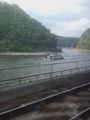
So I don't have to write very much, as my post writers already did tell most of the things, I could tell. I got all the trains to Gernsheim as planned and after a short ride through an ugly industrial area I reached the rhine dike at Biebesheim where I easily found the hashpoint and left a chalk mark (and I was very pleased to read, that someone else found it). The weather was great and I wanted to take pictures of every stork, donkey and the natural reservate Kühkopf, but I had to catch another train and so I must hurry a little bit. I reached the station in Groß Gerau just 10 minutes before the trains departure. This train was 6 minutes late when it arrived at Wiesbaden - very much time when you have 8 minutes to change trains.But whith a little sprint I reached the next train just in time and reached my mothers home at 3 pm.
Next station on my journey was 2014-04-21_50_8.
Danatar
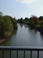
After visiting my parents, I had to get back to Würzburg for night duty on Easter Sunday. The hashpoints were conveniently placed so that I planned to visit two of them without too much of a detour. The first one was 2014-04-20 49 8, near the Rhine at Biebesheim. First I drove to the Autobahn A659, changing to the A6 and A67 after a short time. I left the last one at the Gernsheim exit, driving to Gernsheim. At that time the first of many motorcyclists for the day crossed my path, doing wheelies behind me. At 15:40 I arrived at Biebesheim, parking the car in a parking lot next to the flood protection levee. From there I walked along the Rhine, then followed the levee when it turned away from the river towards the hashpoint. It was a nice walk in the sunshine. The hashpoint was on top of the levee in a place where multiple tracks crossed. My GPS unit located the spot about 2 meters away from DODO’s chalk marks, around 4 p.m.. While I was taking the pictures, a couple with a dog arrived and rested at the bench next to the hashpoint. I saw lots of storks flying around or walking across the meadows, a sign nearby informing me that at Biebesheim there’s an important location for storks, with more than 50 breeding pairs. Then I walked back to my car. I drove via Pfungstadt to the Odenwald, cruising towards the 49 9 hashpoint.
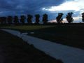
Rincewind & Yakamoz
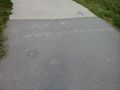
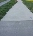
We celebrated Easter Sunday with Rincewind's family with a lavish Asian buffet lunch, paschal lamb cake and chocolate easter bunnies. Afterwards, it was high time we went geohashing. The nearest coordinates were in Biebesheim, 19 km away from home. It was very easy to reach. When we walked back, we almost walked through it, without noticing the handwriting on the ground, but Rincewind still spotted it: An XKCD logo and the link written in chalk... Rincewind supposed DODO could have been there before us. He's right, is he not?...
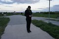
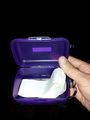
Q-Owl
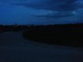
After most members of the family had left, the others wanted to watch "Horsewhisperer" on TV, but I needed some time out. So (without having a look at the wiki) I drove to Biebesheim arriving at 21:30. I found the hashpoint quickly and made the first photos.
But oops! There was some chalk writing on the bike path. *ggg* Very nice to see this kind of greeting, confirming that I am not the only geohash freak in this area. ;-)
After that I looked for the geocache GC2RRTR. Not easy in the darkness.
Photos
DODO

bike near the hash

proof

some easter eggs

grinning
the first photo of the chalk mark

one stork photo (I can't resist)
Kühkopf
river rhine seen from the train


Danatar

the Rhine

walking along the levee

GPS, chalk marker in the background

coordinates reached

panorama

hashdog

storks


Rincewind & Yakamoz
Coordinates reached

Hashgrin...
Discovery on the road


Q-Owl
view east

view northeast
view north

message on the bottom

grin

fighting storks
Geocache


Achievements / Honorable Mention
DODO, Danatar, Rincewind&Yakamoz and Q-Owl earned the Avoid Each Other Achievement
|
Rincewind and Yakamoz earned the Land geohash achievement
|
Q-Owl earned the Land geohash achievement
|
Q-Owl earned the Hash collision honorable mention
|
150 m from the hashpoint, but not in direct sight
Yes, I know, thats boring, but just for completeness:
DODO earned the Land geohash achievement
|
And since I haven't made all the way to the hash on bike, I had to change this into my first
DODO earned the Public transport geohash achievement
|