Difference between revisions of "2014-04-22 50 8"
imported>DODO (→Expedition) |
|||
| (10 intermediate revisions by 2 users not shown) | |||
| Line 17: | Line 17: | ||
<!-- edit as necessary --> | <!-- edit as necessary --> | ||
__NOTOC__ | __NOTOC__ | ||
| + | [[2014-04-21_50_8|previous]] [[2014-04-23 49 8|next]] | ||
| + | |||
== Location == | == Location == | ||
<!-- where you've surveyed the hash to be --> | <!-- where you've surveyed the hash to be --> | ||
| Line 24: | Line 26: | ||
<!-- who attended: If you link to your wiki user name in this section, your expedition will be picked up by the various statistics generated for geohashing. You may use three tildes ~ as a shortcut to automatically insert the user signature of the account you are editing with. | <!-- who attended: If you link to your wiki user name in this section, your expedition will be picked up by the various statistics generated for geohashing. You may use three tildes ~ as a shortcut to automatically insert the user signature of the account you are editing with. | ||
--> | --> | ||
| + | [[User:DODO|DODO]] | ||
== Plans == | == Plans == | ||
| Line 31: | Line 34: | ||
== Expedition == | == Expedition == | ||
<!-- how it all turned out. your narrative goes here. --> | <!-- how it all turned out. your narrative goes here. --> | ||
| − | + | Once again the weather was fine and so I started for another beautiful hash day after a fulminant breakfast in my hotel. The first 23 kilometers were pretty easy as I followed the valley of the river Dill. Then I had to change to the Lahn valley which I just crossed to a long but smooth ascent to reach the Weil valley. On the top of that hill was a beautiful lake which invited me for a picnic, and down in Weilmünster was an ice cream parlour and I couldn't resist. Strengthed this way the next ascent went very well. Only 3 KM left to the hashpoint - but then, the rain started. The next village wasn't far away and soon I found a protecting bus stop, but I was already completely wet. Now you will come to know, why I have these two big bags at my bike: I could change my clothes (a little risky in a glass bus stop). Soon after that the rain stopped and I continued the ride through the fresh washed world. The way continues through a small valley with woods and meadows which looked very inspiring after the rain, and big flows of water were running over all pathes; well, I was already used to get wet and dirty on my bike from yesterday. | |
| + | |||
| + | On a meadow at the exact end of the valley was the hashpoint. I just had to fix my bike and walk into the meadow. I wondered weather I should put of my shoes, but as I didn't have a ring with me, no hobbit achievement was possible, and with so wet shoes a honorable mention of a drowned rat is more than appropriate. I left a little mark at the place where I parked my bike. Then I went on to the Saalburg, a former roman fort, that was rebuild in the 19. century, as emperor Wilhelm was a big fan of the romans (and the limes went along this place). Unfortunately it was a little to late for a visit, so a photo had to do. Now I could enjoy the descent from the Taunus mountains for the last 8 KM of my trip. | ||
| + | |||
| + | At the tourist information in Bad Homburg I found out, that there is a restaurant in Bad Homburg that is decorated with a star by michelin; and the hotel, it belongs to, was not to expensive (and had a bath tub in my room). But these experiences belong to another story. Only so much: I had an extraordinary evening. | ||
| + | |||
| + | Last station on my journey was [[2014-04-21_50_8]]. | ||
| + | |||
| + | Next station on my journey was [[2014-04-23_49_8]]. | ||
== Tracklog == | == Tracklog == | ||
<!-- if your GPS device keeps a log, you may post a link here --> | <!-- if your GPS device keeps a log, you may post a link here --> | ||
| + | [[http://www.gpsies.com/map.do?fileId=guvjenavhlfarhns bike: 91 KM]] | ||
== Photos == | == Photos == | ||
| Line 41: | Line 53: | ||
--> | --> | ||
<gallery perrow="5"> | <gallery perrow="5"> | ||
| + | Image:2014-04-22_50_8-1.jpg|it all started today at this hotel in Dillenburg | ||
| + | Image:2014-04-22_50_8-2.jpg|soon I reached the beautiful city of Herborn | ||
| + | Image:2014-04-22_50_8-3.jpg|After 40 km and the second ascent I reached this beautiful lake and had some picnic | ||
| + | Image:2014-04-22_50_8-4.jpg|and some dessert in the valley after the descent | ||
| + | Image:2014-04-22_50_8-5.jpg|3 KM to the hash - the rain was a little early for a drowned rat | ||
| + | Image:2014-04-22_50_8-6.jpg|it rained so much that the water was foaming on the road | ||
| + | Image:2014-04-22_50_8-7.jpg|the hash lies on the meadow at the end of this road | ||
| + | Image:2014-04-22_50_8-8.jpg|proof | ||
| + | Image:2014-04-22_50_8-9.jpg|clammy grin | ||
| + | Image:2014-04-22_50_8-12.jpg|very wet shoes | ||
| + | Image:2014-04-22_50_8-10.jpg|view from the hash to my parking bike | ||
| + | Image:2014-04-22_50_8-extra.jpg|view from the hash | ||
| + | Image:2014-04-22_50_8-11.jpg|these flowers gained a couch potato achievement | ||
| + | Image:2014-04-22_50_8-13.jpg|left a mark at the bike parking | ||
| + | Image:2014-04-22_50_8-14.jpg|the saalburg, aroman fort, rebuild in the 19th century | ||
</gallery> | </gallery> | ||
| Line 48: | Line 75: | ||
| − | + | {{land geohash | |
| − | + | | latitude = 50 | |
| − | + | | longitude = 8 | |
| + | | date = 2014-04-22 | ||
| + | | name = DODO | ||
| + | }} | ||
| + | |||
| + | {{bicycle geohash | ||
| + | | latitude = 50 | ||
| + | | longitude = 8 | ||
| + | | date = 2014-04-22 | ||
| + | | name = DODO | ||
| + | | distance = 91 KM | ||
| + | }} | ||
| − | + | {{consecutive geohash | |
| + | | count = 3 | ||
| + | | latitude = 49 | ||
| + | | longitude = 8 | ||
| + | | date = 2014-04-20 | ||
| + | | name = DODO | ||
| + | }} | ||
| − | + | {{Drowned rat geohash | |
| − | + | | latitude = 50 | |
| − | + | | longitude = 8 | |
| − | + | | date = 2014-04-22 | |
| + | | name = DODO | ||
| + | | image = 2014-04-22_50_8-5.jpg | ||
| + | | honourable = yes | ||
| + | }} | ||
| − | + | [[Category:Expeditions]] | |
| − | |||
| − | |||
| − | |||
| − | [[Category:Expeditions | ||
| − | |||
| − | |||
| − | |||
| − | |||
[[Category:Coordinates reached]] | [[Category:Coordinates reached]] | ||
| − | + | {{location|DE|HE|HG}} | |
| − | |||
| − | |||
| − | |||
| − | |||
| − | |||
| − | |||
| − | |||
| − | |||
| − | |||
| − | |||
| − | |||
| − | |||
| − | |||
| − | |||
| − | |||
| − | |||
| − | |||
Latest revision as of 16:46, 27 April 2020
| Tue 22 Apr 2014 in 50,8: 50.3287890, 8.4647718 geohashing.info google osm bing/os kml crox |
Location
A field in the north of Merzhausen.
Participants
Plans
To go there by bike from Dillenburg and go on to Saalburg.
Expedition
Once again the weather was fine and so I started for another beautiful hash day after a fulminant breakfast in my hotel. The first 23 kilometers were pretty easy as I followed the valley of the river Dill. Then I had to change to the Lahn valley which I just crossed to a long but smooth ascent to reach the Weil valley. On the top of that hill was a beautiful lake which invited me for a picnic, and down in Weilmünster was an ice cream parlour and I couldn't resist. Strengthed this way the next ascent went very well. Only 3 KM left to the hashpoint - but then, the rain started. The next village wasn't far away and soon I found a protecting bus stop, but I was already completely wet. Now you will come to know, why I have these two big bags at my bike: I could change my clothes (a little risky in a glass bus stop). Soon after that the rain stopped and I continued the ride through the fresh washed world. The way continues through a small valley with woods and meadows which looked very inspiring after the rain, and big flows of water were running over all pathes; well, I was already used to get wet and dirty on my bike from yesterday.
On a meadow at the exact end of the valley was the hashpoint. I just had to fix my bike and walk into the meadow. I wondered weather I should put of my shoes, but as I didn't have a ring with me, no hobbit achievement was possible, and with so wet shoes a honorable mention of a drowned rat is more than appropriate. I left a little mark at the place where I parked my bike. Then I went on to the Saalburg, a former roman fort, that was rebuild in the 19. century, as emperor Wilhelm was a big fan of the romans (and the limes went along this place). Unfortunately it was a little to late for a visit, so a photo had to do. Now I could enjoy the descent from the Taunus mountains for the last 8 KM of my trip.
At the tourist information in Bad Homburg I found out, that there is a restaurant in Bad Homburg that is decorated with a star by michelin; and the hotel, it belongs to, was not to expensive (and had a bath tub in my room). But these experiences belong to another story. Only so much: I had an extraordinary evening.
Last station on my journey was 2014-04-21_50_8.
Next station on my journey was 2014-04-23_49_8.
Tracklog
Photos
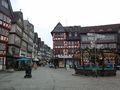
it all started today at this hotel in Dillenburg
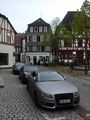
soon I reached the beautiful city of Herborn
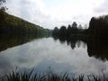
After 40 km and the second ascent I reached this beautiful lake and had some picnic
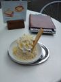
and some dessert in the valley after the descent
3 KM to the hash - the rain was a little early for a drowned rat
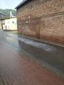
it rained so much that the water was foaming on the road
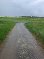
the hash lies on the meadow at the end of this road
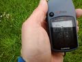
proof
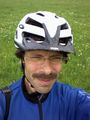
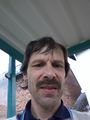
clammy grin
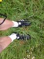
very wet shoes
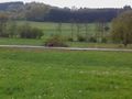
view from the hash to my parking bike
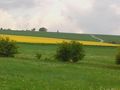
view from the hash
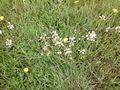
these flowers gained a couch potato achievement
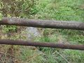
left a mark at the bike parking
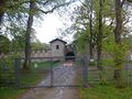
the saalburg, aroman fort, rebuild in the 19th century


Achievements
DODO earned the Land geohash achievement
|
DODO earned the Bicycle geohash achievement
|
DODO earned the Consecutive geohash achievement
|
DODO earned the Drowned Rat Geohash Honourable Mention
|