Difference between revisions of "2014-04-23 49 8"
imported>DODO (→Location) |
|||
| (12 intermediate revisions by 3 users not shown) | |||
| Line 17: | Line 17: | ||
<!-- edit as necessary --> | <!-- edit as necessary --> | ||
__NOTOC__ | __NOTOC__ | ||
| + | [[2014-04-22_50_8|previous]] [[2014-04-30 49 8|next]] | ||
| + | |||
== Location == | == Location == | ||
<!-- where you've surveyed the hash to be --> | <!-- where you've surveyed the hash to be --> | ||
| Line 24: | Line 26: | ||
<!-- who attended: If you link to your wiki user name in this section, your expedition will be picked up by the various statistics generated for geohashing. You may use three tildes ~ as a shortcut to automatically insert the user signature of the account you are editing with. | <!-- who attended: If you link to your wiki user name in this section, your expedition will be picked up by the various statistics generated for geohashing. You may use three tildes ~ as a shortcut to automatically insert the user signature of the account you are editing with. | ||
--> | --> | ||
| + | [[User:DODO|DODO]] | ||
== Plans == | == Plans == | ||
<!-- what were the original plans --> | <!-- what were the original plans --> | ||
| + | To ride from Bad Homburg to Heppenheim by train and then by bike via the hashpoint home to Speyer. | ||
== Expedition == | == Expedition == | ||
| − | + | ||
| + | I started pretty early at 9 am in Bad Homburg at the hotel, got the train to Frankfurt at 9:30 and continued to Heppenheim at 10:06. Immediate after Heppenheim started the hardest part of the whole holiday: the ascent to Juhöhe from 100m to 420m in 6 KM (and nearly an hour). I didn't follow the busy street for the most time but some forest pathes that were even steeper than the street, which soon was far below me. As the dusty ground didn't give enough grip in the steep ground, I had to push my bike for some distances. The descent wasn't that much fun either as it had some water gutters in it that worked like [http://what-if.xkcd.com/61/ speed bumps]. | ||
| + | |||
| + | But the way through the Mörlenbach valley was as great as the weather and soon enough I reached the point where - according to [http://www.komoot.de/tour/2635798 komoot] - was the closest road to the hash. Here I found out that I forgot to load the hashpoint to my Garmin and hashdroid didn't work without internet either. All I had was the waypoint on my komoot-app. The road was a dead end leading to private property but immediate before that there was a very steep meadow that leads into a forest. I decided to climb up the meadow, but when I reached the forest it was impassable as it was full of thorn hedges and not far away I saw a fence that blocked the way anyway. | ||
| + | |||
| + | I was about to give up but the map shows me a road through the forrest 200 m further and I decided to make another attempt from there. I nearly forgot why I was there, when there were some - no, not kittens but - goats. But duty was calling and so I parked my bike and climbed through the forrest. I was very slow as the groud was steep like hell and I was always in danger to slip down the hill. There were some houses below me and some people in the gardens watched me and were certainly wondering what I was doing in their (felt) backyard, but as I was 100 m away (and around 20 m above), they couldn't ask. Step by step I came closer to the desired waypoint and just before I reached the fence again, which I have seen from the other side, the two points covered each other. The accuracy of the map wasn't very good, and so I wasn't sure if I was good enough, but I couldn't do better now. I even found another path some meters above me which was much more convenient for my way back to the bike, but before that I took some photos and had some strawberries (what should suffice for a picnic achievement (if I was at the hash at all)). | ||
| + | |||
| + | On the other side of Weiher another very steep ascent awaits me and led me below a beautiful train bridge. After that I could ride in a gentle valley down to Weinheim and through the rhine plain back home, not without having a stop at Ladenburg for some ice cream and some weiss beer. | ||
| + | Back at home I loaded up my track and found out that I was maximum 5 m of the hashpoint. Given the accuracy within the dense forrest I think I can claim a success for that. | ||
| + | |||
| + | Last station on my journey was [[2014-04-22_50_8]]. | ||
== Tracklog == | == Tracklog == | ||
<!-- if your GPS device keeps a log, you may post a link here --> | <!-- if your GPS device keeps a log, you may post a link here --> | ||
| + | [[http://www.gpsies.com/map.do?fileId=jnuvznpflyutijts bike: 74 km , train: 73 KM]] | ||
== Photos == | == Photos == | ||
| Line 39: | Line 54: | ||
--> | --> | ||
<gallery perrow="5"> | <gallery perrow="5"> | ||
| + | Image:2014-04-23_49_8-1.jpg | Hotel in Bad Homburg | ||
| + | Image:2014-04-23_49_8-2.jpg | Bad Homburg | ||
| + | Image:2014-04-23_49_8-3.jpg | steep and dusty ("Es führt kein and'rer Weg nach Küssnacht") | ||
| + | Image:2014-04-23_49_8-4.jpg | at the top in Juhöhe | ||
| + | Image:2014-04-23_49_8-5.jpg | The hash is above this meadow | ||
| + | Image:2014-04-23_49_8-6.jpg | ...but the copse is impassable (the fence is visible in the background) | ||
| + | Image:2014-04-23_49_8-7.jpg | goats at the second attempt | ||
| + | Image:2014-04-23_49_8-8.jpg | bike parking | ||
| + | Image:2014-04-23_49_8-13.jpg | the houses below me | ||
| + | Image:2014-04-23_49_8-9.jpg | the fence again, this time from the other side | ||
| + | Image:2014-04-23_49_8-10.jpg | somewhere here is the hashpoint | ||
| + | Image:2014-04-23_49_8-11.jpg | the "way back" | ||
| + | Image:2014-04-23_49_8-12.jpg | unsure, so no grin | ||
| + | Image:2014-04-23_49_8-14.jpg | strawberries, anyway | ||
| + | Image:2014-04-23_49_8-15.jpg | old bridge | ||
| + | Image:2014-04-23_49_8-16.jpg | Ladenburg | ||
| + | Image:2014-04-23_49_8-17.jpg | the ferry from [[2014-02-08 49 8]] again | ||
</gallery> | </gallery> | ||
| Line 44: | Line 76: | ||
{{#vardefine:ribbonwidth|800px}} | {{#vardefine:ribbonwidth|800px}} | ||
<!-- Add any achievement ribbons you earned below, or remove this section --> | <!-- Add any achievement ribbons you earned below, or remove this section --> | ||
| + | {{land geohash | ||
| + | | latitude = 49 | ||
| + | | longitude = 8 | ||
| + | | date = 2014-04-23 | ||
| + | | name = DODO | ||
| + | }} | ||
| − | + | {{Public transport geohash | |
| − | + | | latitude = 49 | |
| − | + | | longitude = 8 | |
| + | | date = 2014-04-23 | ||
| + | | name = DODO | ||
| + | }} | ||
| + | {{Picnic_geohash | ||
| + | | latitude = 49 | ||
| + | | longitude = 8 | ||
| + | | date = 2014-04-23 | ||
| + | | name = DODO | ||
| + | | image = 2014-04-23 49 8-14.jpg | ||
| + | | food = strawberries | ||
| + | }} | ||
| − | + | {{consecutive geohash | |
| + | | count = 4 | ||
| + | | latitude = 49 | ||
| + | | longitude = 8 | ||
| + | | date = 2014-04-20 | ||
| + | | name = DODO | ||
| + | }} | ||
| − | |||
| − | |||
| − | |||
| − | |||
| − | |||
| − | |||
[[Category:Expeditions]] | [[Category:Expeditions]] | ||
| − | |||
[[Category:Expeditions with photos]] | [[Category:Expeditions with photos]] | ||
| − | |||
| − | |||
| − | |||
| − | |||
| − | |||
[[Category:Coordinates reached]] | [[Category:Coordinates reached]] | ||
| − | + | {{location|DE|HE|HP}} | |
| − | |||
| − | |||
| − | |||
| − | |||
| − | |||
| − | |||
| − | |||
| − | |||
| − | |||
| − | |||
| − | |||
| − | |||
| − | |||
| − | |||
| − | |||
| − | |||
| − | |||
Latest revision as of 10:41, 29 April 2020
| Wed 23 Apr 2014 in 49,8: 49.5853154, 8.7706798 geohashing.info google osm bing/os kml crox |
Location
Near Moerlenbach-Weiher.
Participants
Plans
To ride from Bad Homburg to Heppenheim by train and then by bike via the hashpoint home to Speyer.
Expedition
I started pretty early at 9 am in Bad Homburg at the hotel, got the train to Frankfurt at 9:30 and continued to Heppenheim at 10:06. Immediate after Heppenheim started the hardest part of the whole holiday: the ascent to Juhöhe from 100m to 420m in 6 KM (and nearly an hour). I didn't follow the busy street for the most time but some forest pathes that were even steeper than the street, which soon was far below me. As the dusty ground didn't give enough grip in the steep ground, I had to push my bike for some distances. The descent wasn't that much fun either as it had some water gutters in it that worked like speed bumps.
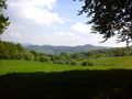
But the way through the Mörlenbach valley was as great as the weather and soon enough I reached the point where - according to komoot - was the closest road to the hash. Here I found out that I forgot to load the hashpoint to my Garmin and hashdroid didn't work without internet either. All I had was the waypoint on my komoot-app. The road was a dead end leading to private property but immediate before that there was a very steep meadow that leads into a forest. I decided to climb up the meadow, but when I reached the forest it was impassable as it was full of thorn hedges and not far away I saw a fence that blocked the way anyway.
I was about to give up but the map shows me a road through the forrest 200 m further and I decided to make another attempt from there. I nearly forgot why I was there, when there were some - no, not kittens but - goats. But duty was calling and so I parked my bike and climbed through the forrest. I was very slow as the groud was steep like hell and I was always in danger to slip down the hill. There were some houses below me and some people in the gardens watched me and were certainly wondering what I was doing in their (felt) backyard, but as I was 100 m away (and around 20 m above), they couldn't ask. Step by step I came closer to the desired waypoint and just before I reached the fence again, which I have seen from the other side, the two points covered each other. The accuracy of the map wasn't very good, and so I wasn't sure if I was good enough, but I couldn't do better now. I even found another path some meters above me which was much more convenient for my way back to the bike, but before that I took some photos and had some strawberries (what should suffice for a picnic achievement (if I was at the hash at all)).
On the other side of Weiher another very steep ascent awaits me and led me below a beautiful train bridge. After that I could ride in a gentle valley down to Weinheim and through the rhine plain back home, not without having a stop at Ladenburg for some ice cream and some weiss beer. Back at home I loaded up my track and found out that I was maximum 5 m of the hashpoint. Given the accuracy within the dense forrest I think I can claim a success for that.
Last station on my journey was 2014-04-22_50_8.
Tracklog
Photos
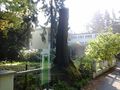
Hotel in Bad Homburg
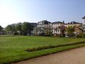
Bad Homburg
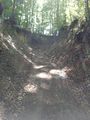
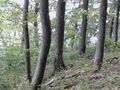
steep and dusty ("Es führt kein and'rer Weg nach Küssnacht")
at the top in Juhöhe
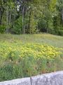
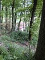
The hash is above this meadow
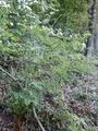
...but the copse is impassable (the fence is visible in the background)
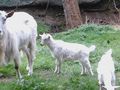
goats at the second attempt
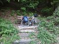
bike parking
the houses below me
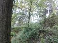
the fence again, this time from the other side
somewhere here is the hashpoint
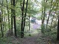
the "way back"

unsure, so no grin
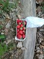
strawberries, anyway
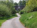
old bridge
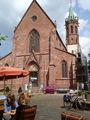
Ladenburg
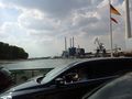
the ferry from 2014-02-08 49 8 again


Achievements
DODO earned the Land geohash achievement
|
DODO earned the Public transport geohash achievement
|
DODO earned the Picnic achievement
|
DODO earned the Consecutive geohash achievement
|