Difference between revisions of "2014-04-24 59 15"
From Geohashing
imported>Belteshassar (→Participants) |
imported>FippeBot m (Location) |
||
| (7 intermediate revisions by one other user not shown) | |||
| Line 29: | Line 29: | ||
== Expedition == | == Expedition == | ||
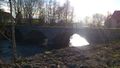
| − | + | Beautiful sunny spring day. A slight headwind when I turned my bike southwards after work. Some 10 km later I reached the coordinates. After a quick photo shoot I turned back home. | |
== Tracklog == | == Tracklog == | ||
| Line 41: | Line 41: | ||
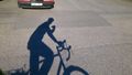
Image:2014-04-24_59_15_Belteshassar_-1.jpg | 10 km detour on my way home from work. Only 15 km to go now. [http://www.openstreetmap.org/?lat=59.17288174&lon=15.26296957&zoom=16&layers=B000FTF @59.1729,15.2630] | Image:2014-04-24_59_15_Belteshassar_-1.jpg | 10 km detour on my way home from work. Only 15 km to go now. [http://www.openstreetmap.org/?lat=59.17288174&lon=15.26296957&zoom=16&layers=B000FTF @59.1729,15.2630] | ||
| + | |||
| + | Image:2014-04-24_59_15_Belteshassar_1398355013924.jpg | | ||
| + | |||
| + | Image:2014-04-24_59_15_Belteshassar_1398355890407.jpg | | ||
</gallery> | </gallery> | ||
== Achievements == | == Achievements == | ||
{{#vardefine:ribbonwidth|800px}} | {{#vardefine:ribbonwidth|800px}} | ||
| − | |||
| + | {{land geohash | ||
| + | | latitude = 59 | ||
| + | | longitude = 15 | ||
| + | | date = 2014-04-24 | ||
| + | | name = Belteshassar | ||
| + | }} | ||
| − | + | {{bicycle geohash | |
| − | + | | latitude = 59 | |
| − | + | | longitude = 15 | |
| − | + | | date = 2014-04-24 | |
| − | + | | name = Belteshassar | |
| − | + | | distance = 25 km | |
| − | + | | bothways = true | |
| − | + | }} | |
| − | |||
| − | |||
| − | |||
[[Category:Expeditions]] | [[Category:Expeditions]] | ||
| − | + | [[Category:Expeditions with photos]] | |
| − | [[Category:Expeditions with photos]] | ||
| − | |||
| − | |||
| − | |||
| − | |||
| − | |||
[[Category:Coordinates reached]] | [[Category:Coordinates reached]] | ||
| − | + | {{location|SE|T}} | |
| − | |||
| − | |||
| − | |||
| − | |||
| − | |||
| − | |||
| − | |||
| − | |||
| − | |||
| − | |||
| − | |||
| − | |||
| − | |||
| − | |||
| − | |||
| − | |||
| − | |||
Latest revision as of 06:18, 14 August 2019
| Thu 24 Apr 2014 in 59,15: 59.1728927, 15.2629421 geohashing.info google osm bing/os kml crox |
Location
In a field 16 km (10 mi) south of Örebro right beside road 51.
Participants
Plans
Expedition
Beautiful sunny spring day. A slight headwind when I turned my bike southwards after work. Some 10 km later I reached the coordinates. After a quick photo shoot I turned back home.
Tracklog
Photos

10 km detour on my way home from work. Only 15 km to go now. @59.1729,15.2630


Achievements
Belteshassar earned the Land geohash achievement
|
Belteshassar earned the Bicycle geohash achievement
|