Difference between revisions of "2014-04-27 52 -0"
From Geohashing
imported>Macronencer (Plans) |
imported>Macronencer (Add a location map) |
||
| Line 1: | Line 1: | ||
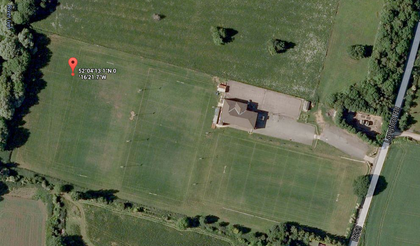
| + | [[Image:{{{image|2014-04-27 52 -0 01 map.png}}}|left|420px]] | ||
| − | |||
| − | |||
| − | |||
| − | |||
| − | |||
| − | |||
| − | |||
| − | |||
| − | |||
{{meetup graticule | {{meetup graticule | ||
| lat=52 | | lat=52 | ||
Revision as of 23:16, 26 April 2014
| Sun 27 Apr 2014 in 52,-0: 52.0703144, -0.2727035 geohashing.info google osm bing/os kml crox |
Location
Biggleswade Rugby Club
Participants
Plans
Macronencer is returning from a trip and hopes to do this one on his way through, to help him get another level on the Minesweeper Achievement. Any locals who want to come along are welcome! Please edit this page if you plan to come. I expect to be there early to mid afternoon.
Expedition
Tracklog
Photos
Achievements
