Difference between revisions of "2014-04-29 50 10"
imported>FeepingCreature m (I'll put up detailed log and photos later today) |
imported>FippeBot m (Location) |
||
| (4 intermediate revisions by 2 users not shown) | |||
| Line 15: | Line 15: | ||
== Plans == | == Plans == | ||
| − | + | [[User:FeepingCreature|Feep]] and [[User:Mampfred|Mampfred]] agreed on IRC to meet around 7pm. | |
== Expedition == | == Expedition == | ||
| − | + | === Mampfred === | |
| + | Leaving work a bit earlier, Mampfred quickly changed clothes and went to see his trusted [http://www.flinkster.de Hash car]. The booking was for two hours which should have been plenty to get there, walk to the hash, meet up and head back. | ||
| + | The hash field was easy to find thanks to Google navigation. As Mampfred was early he decided to walk around the field to the edge that was closest to the actual hash. He got there around 6:55 and started waiting for [[User:FeepingCreature|Feep]]. Mampfred had given [[User:FeepingCreature|Feep]] his number but unfortunately had no way of contacting him the other way round. | ||
| + | |||
| + | At 7:20 he still hadn't heard anything so he gave up waiting and went into the field. The hash was conveniently only eight meters from a large tire track. He took a screenshot and a stupid non-grin and went on the way back out of the field when ... | ||
| + | |||
| + | ... his mobile started ringing and a breathless [[User:FeepingCreature|Feep]] explained that he underestimated the a hill coming from Erfurt :) | ||
| + | |||
| + | So Mampfred went back out and waited some more and eventually [[User:FeepingCreature|Feep]] emerged ... on the other side of the field! | ||
| + | |||
| + | After some more talking on the phone both hashers decided to meet at the hash in the field which they then did. Some more photos were taken and at around 8:15 the two hashers went their seperate ways again. | ||
| + | |||
| + | In the meantime Mampfred had extended the car rental by 30 minutes (yay for modern technology) and made it back just in time. Cost for the car in case you're interested: 12,50 € for the time plus ## insert amount here when the bill comes ## for the distance. | ||
| + | |||
| + | === Feep === | ||
| + | "Oh yeah, 20km of biking should take about an hour." And even then I start late. Of course, I have entirely failed to account for the fact that <i>hills are steep.</i> Also, my phone cannot represent GPS coordinates inside fields, so there's a certain amount of guessing involved regarding where the target area actually is. | ||
| + | |||
| + | "Oh yeah, Mampfred is parked outside <i>the field</i>." The field is kilometers long and not, in fact, completely visible. At the point I am thinking this, I am still about 2km away from the actual meetup point. Good thing we both have mobile phones! Some amount of guesswork later, I manage to get to a point that's at least in line of sight to the geohash. After that it's about five minutes of gratuitous (but sadly, necessary) violence to helpless grains, and I've actually reached my first ever hash point! | ||
| + | |||
| + | Then we go home. | ||
| − | |||
== Tracklog == | == Tracklog == | ||
| − | + | Mampfreds tracklog can be found [http://www.everytrail.com/view_trip.php?trip_id=2758956 here]. | |
== Photos == | == Photos == | ||
| − | |||
| − | |||
| − | |||
<gallery perrow="5"> | <gallery perrow="5"> | ||
| + | Image:2014-04-29_50_10_out_there.jpg | View from the parked car to the hash. | ||
| + | Image:2014-04-29_50_10_track_to_the_hash.jpg | This track leads directly to the hash. Nice. | ||
| + | Image:2014-04-29_50_10_waiting.jpg | Waiting for feep at the edge. | ||
| + | Image:2014-04-29_50_10_stupid_nongrin_first_try.jpg | No feep in sight. Hash is mine. | ||
| + | Image:2014-04-29_50_10_feep_hash_dancing.jpg | Feep hashdancing. | ||
| + | Image:2014-04-29_50_10_20-01_shot_of_the_target_area.jpg | His photos are much better than mine. -Feep | ||
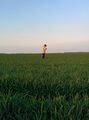
| + | Image:2014-04-29_50_10_coordinates_reached_1.jpg | Coordinates reached. | ||
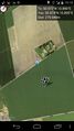
| + | Image:2014-04-29_50_10_19-59_target_coordinate_screenshot.png | Confirmed. -Feep | ||
| + | Image:2014-04-29_50_10_coordinates_reached_2.jpg | ||
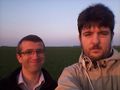
| + | Image:2014-04-29_50_10_do_I_look_bigger_if_I_stretch_myself_a_bit.jpg | Stupid non-grin groupshot. | ||
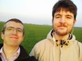
| + | Image:2014-04-29_50_10_20-01_self_portraits.jpg | My phone has a <i>really</i> low resolution on the front. -Feep | ||
| + | Image:2014-04-29_50_10_feep_brought_his_bike_..._into_the_field.jpg | Feep's bike. | ||
</gallery> | </gallery> | ||
== Achievements == | == Achievements == | ||
{{#vardefine:ribbonwidth|800px}} | {{#vardefine:ribbonwidth|800px}} | ||
| − | |||
| − | |||
| − | |||
| − | |||
| − | |||
| − | |||
[[Category:Expeditions]] | [[Category:Expeditions]] | ||
| − | |||
[[Category:Expeditions with photos]] | [[Category:Expeditions with photos]] | ||
| − | |||
| − | |||
| − | |||
| − | |||
| − | |||
[[Category:Coordinates reached]] | [[Category:Coordinates reached]] | ||
| − | + | {{location|DE|TH|EF}} | |
| − | |||
| − | |||
| − | |||
| − | |||
| − | |||
| − | |||
| − | |||
| − | |||
| − | |||
| − | |||
| − | |||
| − | |||
| − | |||
| − | |||
| − | |||
| − | |||
| − | |||
Latest revision as of 06:21, 14 August 2019
| Tue 29 Apr 2014 in 50,10: 50.9718197, 10.8957774 geohashing.info google osm bing/os kml crox |
Location
A field just outside of Erfurt.
Participants
Plans
Feep and Mampfred agreed on IRC to meet around 7pm.
Expedition
Mampfred
Leaving work a bit earlier, Mampfred quickly changed clothes and went to see his trusted Hash car. The booking was for two hours which should have been plenty to get there, walk to the hash, meet up and head back.
The hash field was easy to find thanks to Google navigation. As Mampfred was early he decided to walk around the field to the edge that was closest to the actual hash. He got there around 6:55 and started waiting for Feep. Mampfred had given Feep his number but unfortunately had no way of contacting him the other way round.
At 7:20 he still hadn't heard anything so he gave up waiting and went into the field. The hash was conveniently only eight meters from a large tire track. He took a screenshot and a stupid non-grin and went on the way back out of the field when ...
... his mobile started ringing and a breathless Feep explained that he underestimated the a hill coming from Erfurt :)
So Mampfred went back out and waited some more and eventually Feep emerged ... on the other side of the field!
After some more talking on the phone both hashers decided to meet at the hash in the field which they then did. Some more photos were taken and at around 8:15 the two hashers went their seperate ways again.
In the meantime Mampfred had extended the car rental by 30 minutes (yay for modern technology) and made it back just in time. Cost for the car in case you're interested: 12,50 € for the time plus ## insert amount here when the bill comes ## for the distance.
Feep
"Oh yeah, 20km of biking should take about an hour." And even then I start late. Of course, I have entirely failed to account for the fact that hills are steep. Also, my phone cannot represent GPS coordinates inside fields, so there's a certain amount of guessing involved regarding where the target area actually is.
"Oh yeah, Mampfred is parked outside the field." The field is kilometers long and not, in fact, completely visible. At the point I am thinking this, I am still about 2km away from the actual meetup point. Good thing we both have mobile phones! Some amount of guesswork later, I manage to get to a point that's at least in line of sight to the geohash. After that it's about five minutes of gratuitous (but sadly, necessary) violence to helpless grains, and I've actually reached my first ever hash point!
Then we go home.
Tracklog
Mampfreds tracklog can be found here.
Photos
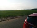
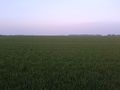
View from the parked car to the hash.
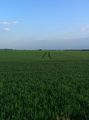
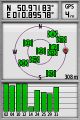
This track leads directly to the hash. Nice.
Waiting for feep at the edge.

No feep in sight. Hash is mine.
Feep hashdancing.
His photos are much better than mine. -Feep
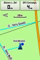
Coordinates reached.
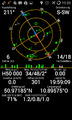
Confirmed. -Feep
Stupid non-grin groupshot.
My phone has a really low resolution on the front. -Feep
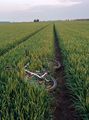
Feep's bike.


