Difference between revisions of "2014-04-30 42 -85"
From Geohashing
imported>Mcbaneg |
imported>FippeBot m (Location) |
||
| (3 intermediate revisions by one other user not shown) | |||
| Line 19: | Line 19: | ||
__NOTOC__ | __NOTOC__ | ||
== Location == | == Location == | ||
| − | Grandville | + | Grandville Cemetery, Grandville, MI, USA |
== Participants == | == Participants == | ||
| Line 39: | Line 39: | ||
--> | --> | ||
<gallery perrow="4"> | <gallery perrow="4"> | ||
| − | Image:2014- | + | Image:2014-04-30 42 -85 6.jpg | View to northeast from hashpoint. |
Image:2014-04-30 42 -85 7.jpg | Yours truly. | Image:2014-04-30 42 -85 7.jpg | Yours truly. | ||
| − | Image:2014-04- | + | Image:2014-04-30_42_-85_proof.png | Proof! |
</gallery> | </gallery> | ||
| Line 65: | Line 65: | ||
[[Category:Expeditions with photos]] | [[Category:Expeditions with photos]] | ||
[[Category:Coordinates reached]] | [[Category:Coordinates reached]] | ||
| + | {{location|US|MI|KN}} | ||
Latest revision as of 06:22, 14 August 2019

| Wed 30 Apr 2014 in 42,-85: 42.9029067, -85.7529821 geohashing.info google osm bing/os kml crox |
Location
Grandville Cemetery, Grandville, MI, USA
Participants
Expedition
Jeez, another cemetery geohash. This one was much less snowy than the last. Mostly I wanted to try out my new toy, my first phone with GPS and Geohash Droid. I suspect my rate of No-Batteries achievements will drop off now.
The closest I saw during the hashdance was something like 0.2 m but the screenshot I caught was just over a meter. GPS Test was reporting an error of 5 m, so I'll take this.
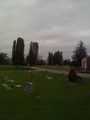
View to northeast from hashpoint.

Yours truly.
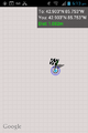
Proof!


Achievements
George earned the Land geohash achievement
|