Difference between revisions of "2014-05-02 44 -123"
imported>Frogman (→Achievements) |
imported>FippeBot m (Location) |
||
| (One intermediate revision by one other user not shown) | |||
| Line 65: | Line 65: | ||
}} | }} | ||
| − | |||
| − | |||
| − | |||
| − | |||
| − | |||
| − | |||
| − | |||
| − | |||
| − | |||
| − | |||
| − | |||
| − | |||
[[Category:Expeditions]] | [[Category:Expeditions]] | ||
| − | |||
[[Category:Expeditions with photos]] | [[Category:Expeditions with photos]] | ||
| − | |||
| − | |||
| − | |||
| − | |||
| − | |||
[[Category:Coordinates reached]] | [[Category:Coordinates reached]] | ||
| − | + | {{location|US|OR|PO}} | |
| − | |||
| − | |||
| − | |||
| − | |||
| − | |||
| − | |||
| − | |||
| − | |||
| − | |||
| − | |||
| − | |||
| − | |||
| − | |||
| − | |||
| − | |||
| − | |||
| − | |||
Latest revision as of 06:25, 14 August 2019
| Fri 2 May 2014 in 44,-123: 44.8398414, -123.2292536 geohashing.info google osm bing/os kml crox |
Location
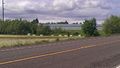
On the shoulder of Oregon Highway 99W, just south of Monmouth, Oregon.
Participants
Plans
I planned on riding my bike up to the hashpoint after class.
Expedition
The journey to the hashpoint went fairly uneventfully. 99W has a lot of hills, but the shoulder was nice and wide and I took a couple of rests. The scenery at the hashpoint was a bit dull. A building! Bees! Cars!
After reaching the hashpoint I went into town. It turns out that the library was holding a used book sale! I went, hoping against all odds to find a book from the Discworld series - I am trying to collect them all with the stipulation that they must be used, and not from a large used bookstore like Powell's. Unfortunately there were none, but I did find a rather odd cookbook. It was specifically raw meals for one or two people, which I anticipate will be very helpful to me as a college student. The design of the cover looked like it had been thrown together in about two minutes. There were pictures of the meals, none of which were on the same page as their recipe. However, it was 50 cents so I bought it.
I asked around about used bookstores in town. The cashier for the book sale pointed me towards a place in Independence. On the way I stopped at the Burgerville for some fries - I was feeling a little weak after the ride up. Then I rode into Independence, but I missed the business hours of the bookstore by about 10 minutes. What a shame!
I decided to ride back down to Corvallis by the auspiciously-named "Corvallis Road", thinking that there would be fewer hills than 99W, as it was along the river. Boy, was I wrong! I ended up heading back over to 99W after a particularly long uphill, and got back into town just before dusk.
My legs feel like they're going to fall off. I am more out of shape than I thought!
Tracklog
Photos
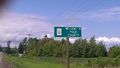
Entering Polk County!
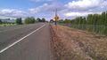
At the hashpoint. In the distance, Monmouth.
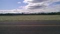
The view from the hashpoint was gorgeous, and pictures don't do it justice.
There were beehives in the nearby field!
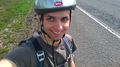
Goofy grin!
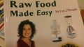
Raw Food Made Easy (for 1 or 2 People)
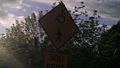
Beware of being crushed by falling wheelchairs!


Achievements
Frogman earned the Bicycle geohash achievement
|