Difference between revisions of "2014-05-02 50 -114"
From Geohashing
imported>Guzzby (→Photos) |
m (More specific location) |
||
| (4 intermediate revisions by 4 users not shown) | |||
| Line 1: | Line 1: | ||
| − | |||
| − | |||
| − | |||
| − | |||
| − | |||
| − | |||
| − | |||
| − | |||
| − | |||
| − | |||
| − | |||
{{meetup graticule | {{meetup graticule | ||
| lat=50 | | lat=50 | ||
| Line 16: | Line 5: | ||
}} | }} | ||
| − | |||
__NOTOC__ | __NOTOC__ | ||
== Location == | == Location == | ||
| − | |||
5 Km Southwest of Red Deer Lake in Calgary, Alberta Canada. | 5 Km Southwest of Red Deer Lake in Calgary, Alberta Canada. | ||
In a field south of Range Road 24 & Township Rd 220A | In a field south of Range Road 24 & Township Rd 220A | ||
== Participants == | == Participants == | ||
| − | |||
| − | |||
* [[User:Guzzby|Guzzby]] | * [[User:Guzzby|Guzzby]] | ||
== Plans == | == Plans == | ||
| − | |||
Plan to drive over to the geohash, take some pictures and find nine geocaches on the way. | Plan to drive over to the geohash, take some pictures and find nine geocaches on the way. | ||
== Expedition == | == Expedition == | ||
| − | |||
I left the house at 12:30 pm. Picked up seven geocaches before I got to the geohash. Ground zero was on private property. I could only get to within 150 meters of the geohash, so I just took some pictures and left. Picked up two more geocaches on the way home. | I left the house at 12:30 pm. Picked up seven geocaches before I got to the geohash. Ground zero was on private property. I could only get to within 150 meters of the geohash, so I just took some pictures and left. Picked up two more geocaches on the way home. | ||
== Photos == | == Photos == | ||
| − | |||
| − | |||
| − | |||
<gallery perrow="5"> | <gallery perrow="5"> | ||
Image:2014-05-02_50_-114_guzzby1.jpg | Point is 150 meters out there. | Image:2014-05-02_50_-114_guzzby1.jpg | Point is 150 meters out there. | ||
| Line 49: | Line 29: | ||
{{#vardefine:ribbonwidth|800px}} | {{#vardefine:ribbonwidth|800px}} | ||
<!-- Add any achievement ribbons you earned below, or remove this section --> | <!-- Add any achievement ribbons you earned below, or remove this section --> | ||
| + | {{No trespassing | latitude = 50 | longitude = -114 | date = 2014-05-02 | name = [[User:Guzzby|Guzzby]] | distance = 150m}} | ||
| − | |||
| − | |||
| − | |||
| − | |||
| − | |||
| − | |||
| − | |||
| − | |||
| − | |||
| − | |||
| − | |||
| − | |||
[[Category:Expeditions]] | [[Category:Expeditions]] | ||
| − | |||
[[Category:Expeditions with photos]] | [[Category:Expeditions with photos]] | ||
| − | |||
| − | |||
| − | |||
| − | |||
| − | |||
| − | |||
| − | |||
| − | |||
| − | |||
[[Category:Coordinates not reached]] | [[Category:Coordinates not reached]] | ||
| − | |||
| − | |||
| − | |||
| − | |||
| − | |||
[[Category:Not reached - No public access]] | [[Category:Not reached - No public access]] | ||
| − | + | {{location|CA|AB|FH}} | |
| − | |||
| − | |||
| − | |||
| − | |||
| − | |||
| − | |||
| − | |||
Latest revision as of 00:07, 10 August 2020
| Fri 2 May 2014 in 50,-114: 50.8398414, -114.2292536 geohashing.info google osm bing/os kml crox |
Location
5 Km Southwest of Red Deer Lake in Calgary, Alberta Canada. In a field south of Range Road 24 & Township Rd 220A
Participants
Plans
Plan to drive over to the geohash, take some pictures and find nine geocaches on the way.
Expedition
I left the house at 12:30 pm. Picked up seven geocaches before I got to the geohash. Ground zero was on private property. I could only get to within 150 meters of the geohash, so I just took some pictures and left. Picked up two more geocaches on the way home.
Photos
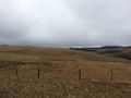
Point is 150 meters out there.
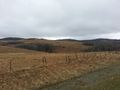
Right of ground zero.
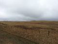
Left of ground zero.


Achievements
Guzzby earned the No trespassing consolation prize
|