Difference between revisions of "2014-05-04 51 11"
imported>TFTD (Page created) |
imported>TFTD (Content) |
||
| Line 19: | Line 19: | ||
== Location == | == Location == | ||
<!-- where you've surveyed the hash to be --> | <!-- where you've surveyed the hash to be --> | ||
| + | Hash is on a field near Teicha and close to the Autobahn A14. | ||
== Participants == | == Participants == | ||
| − | + | [[User:TFTD|TFTD]] ([[User talk:TFTD|talk]]) | |
| − | |||
== Plans == | == Plans == | ||
<!-- what were the original plans --> | <!-- what were the original plans --> | ||
| + | As always. Take my bike, get as close a possible. Walk the rest. Have a fun exercise. | ||
== Expedition == | == Expedition == | ||
<!-- how it all turned out. your narrative goes here. --> | <!-- how it all turned out. your narrative goes here. --> | ||
| + | Today it was cloudy again but additionally it was also cold. I only wear a T-Shirt and a coat which was a little cold in the beginning. The Hash lies close to a path to a route I took before to reach another [[2014-05-04_51_11 | hash]] so I wouldn't need to much orientation breaks. | ||
| + | |||
| + | At first I had to go all the way through Halle and took my first picture leaving Halle. I quickly reached field with the hash and decided to go to the northern edge and try to enter the wield green area from there to get close to the hash before stepping on the field. | ||
| + | |||
| + | Unfortunately I saw fences but decided to try my luck and hoped for holes in the fence or that it might not go as far. I found a small trail which I followed for 2meters and got lucky. The fence ended. It was not used to protect the field but some young trees right next to it. So i walked back a little bit on the edge of the field till I was as close as possible to the coordinates and then entered the field. | ||
| + | |||
| + | I took some pictures. This time (not as on my [[2014-04-03_51_12 | other trip]]) the weather conditions allowed a nice picture of the Petersberg, which was close by. I took a couple more pictures and decided to go for the hunter high level (google translated that word) which I discovered close by. I climbed up and felt a little insecure even tho it was in good condition. But I'm always a chicken if I do potentially dangerous stuff, when by myself. :) | ||
| − | + | So I took two pictures in direction of Halle. On the first one you can see a power plant which I passed by and photographed on my geohashing trip from [[2014-04-03_51_12 | April]]. After that I went back to Halle and decided to discover some areas where I haven't been before and came by a funny placed commercial from a housing corporation. Took a short picture and back home I was. A good 30km trip in not so nice weather conditions but still a nice exercise. | |
| − | |||
== Photos == | == Photos == | ||
| Line 38: | Line 45: | ||
--> | --> | ||
<gallery perrow="5"> | <gallery perrow="5"> | ||
| + | Image:2014-05-04_51-11_01.jpg | Leaving Halle in direction of nowhere. | ||
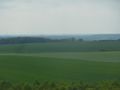
| + | Image:2014-05-04_51-11_02.jpg | The field with the hash, which is straight ahead but just on the other side of the field. | ||
| + | Image:2014-05-04_51-11_03.jpg | Finding a path. | ||
| + | Image:2014-05-04_51-11_04.jpg | Coordinate proof. | ||
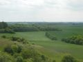
| + | Image:2014-05-04_51-11_06.jpg | The Petersberg [[2014-04-03_51_12 | again]]. View from the coordinates. | ||
| + | Image:2014-05-04_51-11_07.jpg | The A14. View from the coordinates. | ||
| + | Image:2014-05-04_51-11_08.jpg | Trees and my bike (left side). View from the coordinates. | ||
| + | Image:2014-05-04_51-11_09.jpg | Animal trail. | ||
| + | Image:2014-05-04_51-11_10.jpg | Hunter High Level. | ||
| + | Image:2014-05-04_51-11_11.jpg | View to Halle from the hunter high level. Powerplant is the same as from [[2014-04-03_51_12 | this]] trip. | ||
| + | Image:2014-05-04_51-11_12.jpg | View to Halle-Neustadt. | ||
| + | Image:2014-05-04_51-11_13.jpg | The inside of the hunter high level. | ||
| + | Image:2014-05-04_51-11_14.jpg | Funny placed commercial. It's saying "60 years of housing corporation" and in the top left corner "This is accommodation". | ||
</gallery> | </gallery> | ||
| Line 47: | Line 67: | ||
<!-- =============== USEFUL CATEGORIES FOLLOW ================ | <!-- =============== USEFUL CATEGORIES FOLLOW ================ | ||
Delete the next line ONLY if you have chosen the appropriate categories below. If you are unsure, don't worry. People will read your report and help you with the classification.--> | Delete the next line ONLY if you have chosen the appropriate categories below. If you are unsure, don't worry. People will read your report and help you with the classification.--> | ||
| − | |||
| − | |||
| − | |||
| − | |||
| − | |||
| − | |||
| − | |||
| − | |||
| − | |||
| − | |||
[[Category:Expeditions]] | [[Category:Expeditions]] | ||
| − | + | [[Category:Expeditions with photos]] | |
| − | [[Category:Expeditions with photos]] | ||
| − | |||
| − | |||
| − | |||
| − | |||
| − | |||
[[Category:Coordinates reached]] | [[Category:Coordinates reached]] | ||
| − | |||
| − | |||
| − | |||
| − | |||
| − | |||
| − | |||
| − | |||
| − | |||
| − | |||
| − | |||
| − | |||
| − | |||
| − | |||
| − | |||
| − | |||
| − | |||
| − | |||
| − | |||
| − | |||
| − | |||
[[Category: Meetup on 2014-05-04]] | [[Category: Meetup on 2014-05-04]] | ||
[[Category: Meetup in 51 11]] | [[Category: Meetup in 51 11]] | ||
Revision as of 16:07, 4 May 2014
| Sun 4 May 2014 in 51,11: 51.5653046, 11.9848886 geohashing.info google osm bing/os kml crox |
Location
Hash is on a field near Teicha and close to the Autobahn A14.
Participants
Plans
As always. Take my bike, get as close a possible. Walk the rest. Have a fun exercise.
Expedition
Today it was cloudy again but additionally it was also cold. I only wear a T-Shirt and a coat which was a little cold in the beginning. The Hash lies close to a path to a route I took before to reach another hash so I wouldn't need to much orientation breaks.
At first I had to go all the way through Halle and took my first picture leaving Halle. I quickly reached field with the hash and decided to go to the northern edge and try to enter the wield green area from there to get close to the hash before stepping on the field.
Unfortunately I saw fences but decided to try my luck and hoped for holes in the fence or that it might not go as far. I found a small trail which I followed for 2meters and got lucky. The fence ended. It was not used to protect the field but some young trees right next to it. So i walked back a little bit on the edge of the field till I was as close as possible to the coordinates and then entered the field.
I took some pictures. This time (not as on my other trip) the weather conditions allowed a nice picture of the Petersberg, which was close by. I took a couple more pictures and decided to go for the hunter high level (google translated that word) which I discovered close by. I climbed up and felt a little insecure even tho it was in good condition. But I'm always a chicken if I do potentially dangerous stuff, when by myself. :)
So I took two pictures in direction of Halle. On the first one you can see a power plant which I passed by and photographed on my geohashing trip from April. After that I went back to Halle and decided to discover some areas where I haven't been before and came by a funny placed commercial from a housing corporation. Took a short picture and back home I was. A good 30km trip in not so nice weather conditions but still a nice exercise.
Photos
Leaving Halle in direction of nowhere.
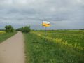
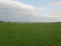
The field with the hash, which is straight ahead but just on the other side of the field.
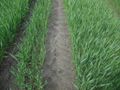
Finding a path.
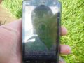
Coordinate proof.
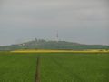
The Petersberg again. View from the coordinates.
The A14. View from the coordinates.
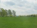
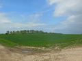
Trees and my bike (left side). View from the coordinates.
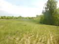
Animal trail.
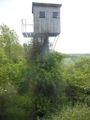
Hunter High Level.
View to Halle from the hunter high level. Powerplant is the same as from this trip.
View to Halle-Neustadt.
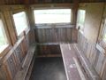
The inside of the hunter high level.
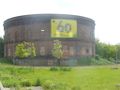
Funny placed commercial. It's saying "60 years of housing corporation" and in the top left corner "This is accommodation".


