Difference between revisions of "2014-05-13 59 17"
From Geohashing
imported>Göran Roseen (→Photos) |
imported>Göran Roseen m |
||
| Line 57: | Line 57: | ||
<!-- Potential categories. Please include all the ones appropriate to your expedition --> | <!-- Potential categories. Please include all the ones appropriate to your expedition --> | ||
| − | |||
| − | |||
| − | |||
| − | |||
| − | |||
[[Category:Expeditions]] | [[Category:Expeditions]] | ||
| − | |||
[[Category:Expeditions with photos]] | [[Category:Expeditions with photos]] | ||
| − | |||
| − | |||
| − | |||
| − | |||
| − | |||
[[Category:Coordinates reached]] | [[Category:Coordinates reached]] | ||
| − | |||
| − | |||
| − | |||
| − | |||
| − | |||
| − | |||
| − | |||
| − | |||
| − | |||
| − | |||
| − | |||
| − | |||
| − | |||
| − | |||
| − | |||
| − | |||
| − | |||
| − | |||
Revision as of 08:56, 14 May 2014
| Tue 13 May 2014 in 59,17: 59.5664352, 17.9052383 geohashing.info google osm bing/os kml crox |
Location
In Rosersberg, North of Stockholm. The point lies in a field, just next to European Highway E4.
Participants
- Göran Roseen (talk)
- Ida
Plans
Thanks to the Geohashing Notifications, I became aware that the next days' hash would be located a few minutes from home.
It was time for my first geohashing expedition!
Expedition
Tracklog
Photos
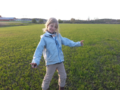
A proud geohasher on her premier expedition

Sunset expedition
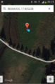
Arrived on the spot


