Difference between revisions of "2014-05-16 47 -122"
From Geohashing
imported>Thomcat ([live picture] [http://www.openstreetmap.org/?lat=47.68441108&lon=-122.02572561&zoom=16&layers=B000FTF @47.6844,-122.0257]) |
imported>Thomcat ([live] Here!) |
||
| Line 22: | Line 22: | ||
| + | |||
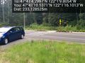
| + | *Here! -- [[User:Thomcat|Thomcat]] ([[User talk:Thomcat|talk]]) [http://www.openstreetmap.org/?lat=47.68455072&lon=-122.01949241&zoom=16&layers=B000FTF @47.6846,-122.0195] 14:54, 16 May 2014 (PDT) | ||
== Tracklog == | == Tracklog == | ||
<!-- if your GPS device keeps a log, you may post a link here --> | <!-- if your GPS device keeps a log, you may post a link here --> | ||
Revision as of 21:54, 16 May 2014
| Fri 16 May 2014 in Seattle: 47.6845277, -122.0193904 geohashing.info google osm bing/os kml crox |
Location
Just off the Woodpecker Trail, in Redmond Ridge East.
Participants
Plans
Stop by after work, then take the toll bridge back to Seattle.
Expedition
Scouted first thing and it looked reasonable. A bit of legwork later on pulled up the name of the trail this hashpoint is near to - Woodpecker Trail. Based on that image, it looks like the hashpoint is close to a proposed trail marker... but then it also shows the trail continuing NW from there instead of angling back to the main road. Time to get a first-hand report!
- Here! -- Thomcat (talk) @47.6846,-122.0195 14:54, 16 May 2014 (PDT)
Tracklog
Photos
North of point - trails match google and not plan. @47.6863,-122.0211


Achievements