Difference between revisions of "2014-05-17 47 -122"
imported>OtherJack (made it. details coming) |
imported>FippeBot m (Location) |
||
| (7 intermediate revisions by one other user not shown) | |||
| Line 34: | Line 34: | ||
Made it, really interesting location and the weather was great. More coming when I have a bit of time | Made it, really interesting location and the weather was great. More coming when I have a bit of time | ||
| − | + | So, I originally wasn't sure if it would even make sense to try this one, since there was a chance of showers and I had both early-afternoon and evening plans. But I finished buying a new suit downtown around 2 or 3 pm, which I figured was ok - I needed to be home for dinner by 6 to have enough time to meet a friend and get to a certain party. The weather was also much sunnier than anticipated. | |
| − | + | ||
| + | So, I set out rather spontaneously, though I'd already written down the coordinates and rough directions. I did not actually have the suit with me (it still had to be tailored) so could not go for the [[Formal attire achievement]] unfortunately. | ||
| + | |||
| + | The bus really took its sweet time through the downtown tunnel and then through Kirkland, but I was eventually delivered to the NE 116th St stop around 3:20 (I think.) The hash appeared to be in a long driveway-thing quite a ways down NE 112th St, which the bus did not stop near... so it was a bit of a hike, much of it uphill. I walked rather quickly since I was trying to catch a 4:07 bus back to Seattle. The setting was quiet, wooded suburbia typical of much of populated Western Washington. | ||
| + | |||
| + | As I neared the GPS-indicated hash longitude, it became clear that the "driveway" was actually a private road, 109th Pl NE, dropping down into a little hollow called Hidden Valley (as indicated on a couple signs.) This was good because it meant multiple families used this road, making me stand out less - but potentially bad if the road right-of-way turned out to be narrow, because it would mean the hashpoint might actually be found in a neighbor's back yard. | ||
| + | |||
| + | There weren't any No Trespassing signs or anything else scary, so I proceeded down the little drive about 15m to the hash latitude. At first the device insisted the point was still well east, into the weeds behind the neighbor's property, but then it came to its senses and decided that the edge of the weeds a couple meters off the road was good enough. Then it really got excited and read 0.00ft! Clearly, I had succeeded. The sole previous time I'd seen a perfect 0.00 was also in Seattle's Eastside suburbs, on [[2013-11-24 47 -122|2013-11-24]]. Interesting. | ||
| + | |||
| + | It was quite a scenic location too - the regular neighborhood above me to the north, and Hidden Valley nestled below me to the south, the road swooping down into it and out of sight. I hoped it was a nice and cozy place, and not a dump. But it was a private road (and time was short) so I headed back rather than exploring further. It was still only 3:45, and I hadn't made any indication to the wiki that I was coming - so I can't count this as a 4pm Saturday Meetup. | ||
| + | |||
| + | On the return walk I caught a few glimpses of Juanita Bay, and when I realized I had five minutes or so before the bus, I strolled over to a long wetland boardwalk with a grand view of this whole part of Lake Washington, including the Juanita Bay beach. I'd never seen this before even though I've lived in the Seattle area almost six years. Maybe this is why I geohash. | ||
| + | |||
| + | The bus back downtown departed very late and also crawled (Sounders game to blame?) but I still got home to leftover goulash and egg noodles in reasonable time. Not a bad hash. | ||
== Photos == | == Photos == | ||
| Line 42: | Line 55: | ||
--> | --> | ||
<gallery perrow="5"> | <gallery perrow="5"> | ||
| + | Image:2014-05-17 15.24.31.jpg | En route | ||
| + | Image:2014-05-17 15.29.11.jpg | Neighborhood is serious about their Seahawks. | ||
| + | Image:2014-05-17 15.36.31.jpg | First view of Hidden Valley. The hash is a few meters behind that sign | ||
| + | Image:2014-05-17_47_-122_OtherJack_1400366386781.jpg | Arrived... in Hidden Valley! | ||
| + | Image:2014-05-17 15.37.41.jpg | 0.00!! | ||
| + | Image:2014-05-17 15.38.55.jpg | The road in | ||
| + | Image:2014-05-17 15.39.00.jpg | The valley | ||
| + | Image:2014-05-17 15.39.04.jpg | Back uphill | ||
| + | Image:2014-05-17 15.39.39.jpg | The weeds | ||
| + | Image:2014-05-17 15.43.21.jpg | More signs | ||
| + | Image:2014-05-17 15.43.27.jpg | ||
| + | Image:2014-05-17 15.43.33.jpg | ||
| + | Image:2014-05-17 16.00.55.jpg | Big boardwalk | ||
| + | Image:2014-05-17 16.01.43.jpg | Juanita Bay! | ||
| + | Image:2014-05-17 16.01.52.jpg | ||
| + | Image:2014-05-17 16.02.33.jpg | The boardwalk turns out to be an old Corduroy Bridge. | ||
| − | |||
</gallery> | </gallery> | ||
| − | |||
== Achievements == | == Achievements == | ||
{{#vardefine:ribbonwidth|800px}} | {{#vardefine:ribbonwidth|800px}} | ||
<!-- Add any achievement ribbons you earned below, or remove this section --> | <!-- Add any achievement ribbons you earned below, or remove this section --> | ||
| + | {{Public transport geohash | ||
| + | | latitude = 47 | ||
| + | | longitude = -122 | ||
| + | | date = 2014-05-17 | ||
| + | | busline = King County Metro | ||
| + | | name = [[User:OtherJack|OtherJack]] | ||
| + | }} | ||
<!-- =============== USEFUL CATEGORIES FOLLOW ================ | <!-- =============== USEFUL CATEGORIES FOLLOW ================ | ||
Delete the next line ONLY if you have chosen the appropriate categories below. If you are unsure, don't worry. People will read your report and help you with the classification.--> | Delete the next line ONLY if you have chosen the appropriate categories below. If you are unsure, don't worry. People will read your report and help you with the classification.--> | ||
| Line 57: | Line 91: | ||
[[Category:Expeditions with photos]] | [[Category:Expeditions with photos]] | ||
[[Category:Coordinates reached]] | [[Category:Coordinates reached]] | ||
| − | + | {{location|US|WA|KN}} | |
| − | |||
| − | |||
| − | |||
| − | |||
| − | |||
| − | |||
| − | |||
| − | |||
| − | |||
| − | |||
| − | |||
| − | |||
| − | |||
| − | |||
| − | |||
| − | |||
| − | |||
| − | |||
| − | |||
| − | |||
| − | |||
| − | |||
| − | |||
| − | |||
| − | |||
| − | |||
| − | |||
| − | |||
| − | |||
| − | |||
| − | |||
| − | |||
| − | |||
| − | |||
Latest revision as of 06:33, 14 August 2019
| Sat 17 May 2014 in 47,-122: 47.7000745, -122.1952239 geohashing.info google osm bing/os kml crox |
Location
Just off the drive leading into Hidden Valley, in the Juanita district of Kirkland
Participants
Plans
I figured I'd hit this if I had time after an errand downtown and weather permitting.
Expedition
Made it, really interesting location and the weather was great. More coming when I have a bit of time
So, I originally wasn't sure if it would even make sense to try this one, since there was a chance of showers and I had both early-afternoon and evening plans. But I finished buying a new suit downtown around 2 or 3 pm, which I figured was ok - I needed to be home for dinner by 6 to have enough time to meet a friend and get to a certain party. The weather was also much sunnier than anticipated.
So, I set out rather spontaneously, though I'd already written down the coordinates and rough directions. I did not actually have the suit with me (it still had to be tailored) so could not go for the Formal attire achievement unfortunately.
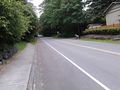
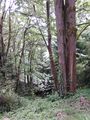
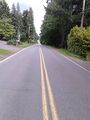
The bus really took its sweet time through the downtown tunnel and then through Kirkland, but I was eventually delivered to the NE 116th St stop around 3:20 (I think.) The hash appeared to be in a long driveway-thing quite a ways down NE 112th St, which the bus did not stop near... so it was a bit of a hike, much of it uphill. I walked rather quickly since I was trying to catch a 4:07 bus back to Seattle. The setting was quiet, wooded suburbia typical of much of populated Western Washington.
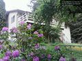
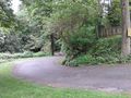
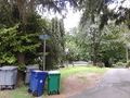
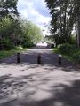
As I neared the GPS-indicated hash longitude, it became clear that the "driveway" was actually a private road, 109th Pl NE, dropping down into a little hollow called Hidden Valley (as indicated on a couple signs.) This was good because it meant multiple families used this road, making me stand out less - but potentially bad if the road right-of-way turned out to be narrow, because it would mean the hashpoint might actually be found in a neighbor's back yard.
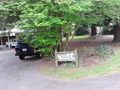
There weren't any No Trespassing signs or anything else scary, so I proceeded down the little drive about 15m to the hash latitude. At first the device insisted the point was still well east, into the weeds behind the neighbor's property, but then it came to its senses and decided that the edge of the weeds a couple meters off the road was good enough. Then it really got excited and read 0.00ft! Clearly, I had succeeded. The sole previous time I'd seen a perfect 0.00 was also in Seattle's Eastside suburbs, on 2013-11-24. Interesting.
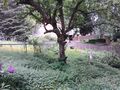
It was quite a scenic location too - the regular neighborhood above me to the north, and Hidden Valley nestled below me to the south, the road swooping down into it and out of sight. I hoped it was a nice and cozy place, and not a dump. But it was a private road (and time was short) so I headed back rather than exploring further. It was still only 3:45, and I hadn't made any indication to the wiki that I was coming - so I can't count this as a 4pm Saturday Meetup.
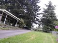
On the return walk I caught a few glimpses of Juanita Bay, and when I realized I had five minutes or so before the bus, I strolled over to a long wetland boardwalk with a grand view of this whole part of Lake Washington, including the Juanita Bay beach. I'd never seen this before even though I've lived in the Seattle area almost six years. Maybe this is why I geohash.
The bus back downtown departed very late and also crawled (Sounders game to blame?) but I still got home to leftover goulash and egg noodles in reasonable time. Not a bad hash.
Photos
En route
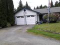
Neighborhood is serious about their Seahawks.

First view of Hidden Valley. The hash is a few meters behind that sign
Arrived... in Hidden Valley!
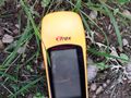
0.00!!
The road in
The valley
Back uphill
The weeds
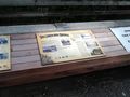
More signs
Big boardwalk
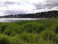
Juanita Bay!
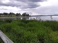
The boardwalk turns out to be an old Corduroy Bridge.


Achievements
OtherJack earned the Public transport geohash achievement
|