Difference between revisions of "2014-05-21 49 8"
imported>DODO m (→Plans) |
|||
| (5 intermediate revisions by 2 users not shown) | |||
| Line 17: | Line 17: | ||
<!-- edit as necessary --> | <!-- edit as necessary --> | ||
__NOTOC__ | __NOTOC__ | ||
| + | [[2014-05-02_49_8|previous]] [[2014-05-26 49 8|next]] | ||
| + | |||
== Location == | == Location == | ||
<!-- where you've surveyed the hash to be --> | <!-- where you've surveyed the hash to be --> | ||
| − | In a small | + | In a small forest east of Neckargemünd. |
== Participants == | == Participants == | ||
| Line 32: | Line 34: | ||
== Expedition == | == Expedition == | ||
<!-- how it all turned out. your narrative goes here. --> | <!-- how it all turned out. your narrative goes here. --> | ||
| + | I got out of the office at 4 o'clock but I totally underestimated the time that I'd need to cross Heidelberg during rush hour. And to ride along the Neckar on the busy road is only half the fun, too. Nevertheless I arrived at the hash at 17:45 and was a little bit disappointed that no one else was there or had been there earlier, although the hashpoint was quite nice. It was in a sparse forest just 10 m away from a path, which was even rideable although it was steep. On my way I bought some strawberries in Neckargemünd. Of course I ate some at the hashpoint, and they turned out to be some of the best strawberries I've ever eaten. I also bought some asparagus on my way in Schwetzingen, and so I had a good dinner this evening, too. | ||
== Tracklog == | == Tracklog == | ||
<!-- if your GPS device keeps a log, you may post a link here --> | <!-- if your GPS device keeps a log, you may post a link here --> | ||
| + | [[http://www.komoot.de/tour/2836493 75 KM bullriding]] | ||
== Photos == | == Photos == | ||
| Line 41: | Line 45: | ||
--> | --> | ||
<gallery perrow="5"> | <gallery perrow="5"> | ||
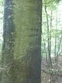
| + | Image:2014-05-21_49_8-1.jpg | the bull on the path. The hash is 10 m to the left | ||
| + | Image:2014-05-21_49_8-2.jpg | proof | ||
| + | Image:2014-05-21_49_8-3.jpg | View from the hash | ||
| + | Image:2014-05-21_49_8-4.jpg | the other direction. You can guess the rod of the bull exactly in the center | ||
| + | Image:2014-05-21_49_8-5.jpg | very stupid grin | ||
| + | Image:2014-05-21_49_8-6.jpg | delicious strawberries | ||
| + | Image:2014-05-21_49_8-7.jpg | I left a mark. Maybe someone will still come along | ||
| + | Image:2014-05-21_49_8-8.jpg | My way home lead through this tunnel. Beyond the grid flows a ditch | ||
| + | Image:2014-05-21_49_8-9.jpg | Caramel, espresso and cookies. Enough refreshment to reach home :-) | ||
</gallery> | </gallery> | ||
| Line 46: | Line 59: | ||
{{#vardefine:ribbonwidth|800px}} | {{#vardefine:ribbonwidth|800px}} | ||
<!-- Add any achievement ribbons you earned below, or remove this section --> | <!-- Add any achievement ribbons you earned below, or remove this section --> | ||
| + | {{land geohash | ||
| + | | latitude = 49 | ||
| + | | longitude = 8 | ||
| + | | date = 2014-05-21 | ||
| + | | name = DODO | ||
| + | }} | ||
| − | + | {{Geohashing Day | |
| − | + | | latitude = 49 | |
| − | + | | longitude = 8 | |
| + | | year = 2014 | ||
| + | | coorddate = 2014-05-21 | ||
| + | | name = DODO | ||
| + | | celebration = eating some of the best strawberries ever | ||
| + | | image=2014-05-21_49_8-6.jpg | ||
| + | }} | ||
| − | |||
| − | |||
| − | |||
| − | |||
| − | |||
| − | |||
| − | |||
| − | |||
[[Category:Expeditions]] | [[Category:Expeditions]] | ||
| − | |||
[[Category:Expeditions with photos]] | [[Category:Expeditions with photos]] | ||
| − | |||
| − | |||
| − | |||
| − | |||
| − | |||
[[Category:Coordinates reached]] | [[Category:Coordinates reached]] | ||
| − | + | {{location|DE|BW|HD}} | |
| − | |||
| − | |||
| − | |||
| − | |||
| − | |||
| − | |||
| − | |||
| − | |||
| − | |||
| − | |||
| − | |||
| − | |||
| − | |||
| − | |||
| − | |||
| − | |||
| − | |||
Latest revision as of 15:21, 1 May 2020
| Wed 21 May 2014 in 49,8: 49.3687540, 8.8289638 geohashing.info google osm bing/os kml crox |
Location
In a small forest east of Neckargemünd.
Participants
Plans
Hey, it's geohashing day and so I want to go to the hash, even it it is a bit far away. I'll try to get there by bullriding after work. I get out of the office now (4 pm) and I will need little more than an hour to get to Neckargemünd. It would be really nice to meet some hashers on this special day.
Expedition
I got out of the office at 4 o'clock but I totally underestimated the time that I'd need to cross Heidelberg during rush hour. And to ride along the Neckar on the busy road is only half the fun, too. Nevertheless I arrived at the hash at 17:45 and was a little bit disappointed that no one else was there or had been there earlier, although the hashpoint was quite nice. It was in a sparse forest just 10 m away from a path, which was even rideable although it was steep. On my way I bought some strawberries in Neckargemünd. Of course I ate some at the hashpoint, and they turned out to be some of the best strawberries I've ever eaten. I also bought some asparagus on my way in Schwetzingen, and so I had a good dinner this evening, too.
Tracklog
Photos
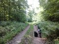
the bull on the path. The hash is 10 m to the left
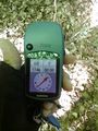
proof
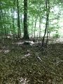
View from the hash
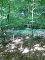
the other direction. You can guess the rod of the bull exactly in the center

very stupid grin
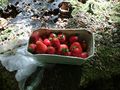
delicious strawberries
I left a mark. Maybe someone will still come along
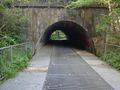
My way home lead through this tunnel. Beyond the grid flows a ditch
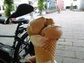
Caramel, espresso and cookies. Enough refreshment to reach home :-)


Achievements
DODO earned the Land geohash achievement
|
DODO earned the 2014 Geohashing Day achievement
|