Difference between revisions of "2014-05-23 50 -115"
imported>Guzzby (→Location) |
m (per Renaming Proposal) |
||
| (14 intermediate revisions by 4 users not shown) | |||
| Line 25: | Line 25: | ||
<!-- who attended: If you link to your wiki user name in this section, your expedition will be picked up by the various statistics generated for geohashing. You may use three tildes ~ as a shortcut to automatically insert the user signature of the account you are editing with. | <!-- who attended: If you link to your wiki user name in this section, your expedition will be picked up by the various statistics generated for geohashing. You may use three tildes ~ as a shortcut to automatically insert the user signature of the account you are editing with. | ||
--> | --> | ||
| + | * [[User:Guzzby|Guzzby]] | ||
== Plans == | == Plans == | ||
<!-- what were the original plans --> | <!-- what were the original plans --> | ||
| + | I see today there is a point I can reach in another graticule, which I need to help me accomplish the Minesweeper geohash achievement. I plan to drive out there around 10:00 am and I should arrive around 12:00 noon. I will take a couple of pictures of the geohash area and then search for two nearby geocaches. If all goes well I should be back home around 3:00 pm | ||
== Expedition == | == Expedition == | ||
<!-- how it all turned out. your narrative goes here. --> | <!-- how it all turned out. your narrative goes here. --> | ||
| − | + | I arrived at 12:00 noon. I parked at the Boulton Creek Trading Post. I grabbed my bear spray (Grizzly bear country out here) and headed north on the trail beside the parking lot. I followed the trail for 500 meters, then I headed into the thick forest. I bush whacked my way through the snow covered forest for 200 meters and reached ground zero. The forest opened up a bit and I was able to take a couple of pictures of the area. I then headed back to the trail and went searching for the nearby geocaches in the area. I found one by the trading post fairly easily, but I had to give up on finding the second one as the area it was in was too marshy to slog through for 300 meters. I returned home to Calgary around 3:00 pm. | |
| − | |||
| − | |||
== Photos == | == Photos == | ||
| Line 40: | Line 40: | ||
--> | --> | ||
<gallery perrow="5"> | <gallery perrow="5"> | ||
| + | Image:2014-05-23_50_-115_guzzby1.jpg | Trail to geohash | ||
| + | Image:2014-05-23_50_-115_guzzby2.jpg | Ground Zero | ||
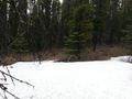
| + | Image:2014-05-23_50_-115_guzzby3.jpg | ||
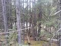
| + | Image:2014-05-23_50_-115_guzzby4.jpg | ||
| + | Image:2014-05-23_50_-115_guzzby5.jpg | ||
</gallery> | </gallery> | ||
| Line 45: | Line 50: | ||
{{#vardefine:ribbonwidth|800px}} | {{#vardefine:ribbonwidth|800px}} | ||
<!-- Add any achievement ribbons you earned below, or remove this section --> | <!-- Add any achievement ribbons you earned below, or remove this section --> | ||
| + | {{Land geohash | latitude = 50 | longitude = -115 | date = 2014-05-23 | name = [[User:Guzzby|Guzzby]] }} | ||
| + | {{Graticule unlocked | latitude = 50 | longitude = -115 | date = 2014-05-23 | name = [[User:Guzzby|Guzzby]] }} | ||
| − | |||
| − | |||
| − | |||
| − | |||
| − | |||
| − | |||
| − | |||
| − | |||
| − | |||
| − | |||
| − | |||
| − | |||
| − | |||
[[Category:Expeditions]] | [[Category:Expeditions]] | ||
| − | |||
[[Category:Expeditions with photos]] | [[Category:Expeditions with photos]] | ||
| − | |||
| − | |||
| − | |||
| − | |||
| − | |||
[[Category:Coordinates reached]] | [[Category:Coordinates reached]] | ||
| − | + | {{location|CA|AB|KA}} | |
| − | |||
| − | |||
| − | |||
| − | |||
| − | |||
| − | |||
| − | |||
| − | |||
| − | |||
| − | |||
| − | |||
| − | |||
| − | |||
| − | |||
| − | |||
| − | |||
| − | |||
Latest revision as of 05:12, 20 March 2024
| Fri 23 May 2014 in 50,-115: 50.6403037, -115.1027419 geohashing.info google osm bing/os kml crox |
Location
In Kananaskis Country a park system situated to the west of Calgary, Alberta, Canada About 700 meters north of Boulton Creek Trading Post.
Participants
Plans
I see today there is a point I can reach in another graticule, which I need to help me accomplish the Minesweeper geohash achievement. I plan to drive out there around 10:00 am and I should arrive around 12:00 noon. I will take a couple of pictures of the geohash area and then search for two nearby geocaches. If all goes well I should be back home around 3:00 pm
Expedition
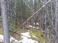
I arrived at 12:00 noon. I parked at the Boulton Creek Trading Post. I grabbed my bear spray (Grizzly bear country out here) and headed north on the trail beside the parking lot. I followed the trail for 500 meters, then I headed into the thick forest. I bush whacked my way through the snow covered forest for 200 meters and reached ground zero. The forest opened up a bit and I was able to take a couple of pictures of the area. I then headed back to the trail and went searching for the nearby geocaches in the area. I found one by the trading post fairly easily, but I had to give up on finding the second one as the area it was in was too marshy to slog through for 300 meters. I returned home to Calgary around 3:00 pm.
Photos
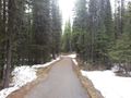
Trail to geohash
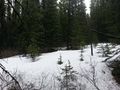
Ground Zero


Achievements
Guzzby earned the Land geohash achievement
|
Guzzby earned the Graticule Unlocked Achievement
|