Difference between revisions of "2014-05-28 43 -116"
From Geohashing
imported>Eldin ([retro picture] The hashpoint.) |
imported>FippeBot m (Location) |
||
| (2 intermediate revisions by one other user not shown) | |||
| Line 1: | Line 1: | ||
| − | |||
| − | |||
| − | |||
| − | |||
| − | |||
| − | |||
| − | |||
| − | |||
| − | |||
{{meetup graticule | {{meetup graticule | ||
| lat=43 | | lat=43 | ||
| Line 14: | Line 5: | ||
}} | }} | ||
| − | |||
__NOTOC__ | __NOTOC__ | ||
| Line 31: | Line 21: | ||
== Photos == | == Photos == | ||
| − | |||
| − | |||
| − | |||
<gallery perrow="5"> | <gallery perrow="5"> | ||
| Line 41: | Line 28: | ||
Image:2014-05-28_43_-116_eldin_1401326689307.jpg | The hashpoint. | Image:2014-05-28_43_-116_eldin_1401326689307.jpg | The hashpoint. | ||
| + | |||
| + | Image:2014-05-28_43_-116_eldin_1401326707121.jpg | View from the hash. | ||
</gallery> | </gallery> | ||
== Achievements == | == Achievements == | ||
{{#vardefine:ribbonwidth|800px}} | {{#vardefine:ribbonwidth|800px}} | ||
| − | + | {{land geohash| latitude = 43| longitude = -116| date = 2014-05-28| name = [[User:Eldin|Eldin]]}} | |
| − | |||
| − | |||
| − | |||
| − | |||
| − | |||
| − | |||
| − | |||
| − | |||
| − | |||
[[Category:Expeditions]] | [[Category:Expeditions]] | ||
| − | |||
[[Category:Expeditions with photos]] | [[Category:Expeditions with photos]] | ||
| − | |||
| − | |||
| − | |||
| − | |||
| − | |||
[[Category:Coordinates reached]] | [[Category:Coordinates reached]] | ||
| − | + | {{location|US|ID|AA}} | |
| − | |||
| − | |||
| − | |||
| − | |||
| − | |||
| − | |||
| − | |||
| − | |||
| − | |||
| − | |||
| − | |||
| − | |||
| − | |||
| − | |||
| − | |||
| − | |||
| − | |||
Latest revision as of 06:42, 14 August 2019
| Wed 28 May 2014 in 43,-116: 43.6422773, -116.1964563 geohashing.info google osm bing/os kml crox |
Location
Hull's Gulch, in the Boise foothills.
Participants
Plans
The point looked to be accessible, and not terribly far away. So I decided to make a try for it after work.
Expedition
I parked at the trailhead for one of the trails which went relatively near the hashpoint, and set out walking. It was a beautiful day for a hike in the hills, though I do wish I'd had a change of clothes rather than hiking it in my work clothes. It was only about 3/4 of a mile's hike to the spot, but the trail went up a hill, down into a valley, and then back up another hill to get to the spot, so it was a decent workout for such a short hike. At the spot I took some pictures, then headed back.
Photos

Proof

Geohasher at the spot.
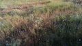
The hashpoint.
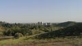
View from the hash.


Achievements
Eldin earned the Land geohash achievement
|