Difference between revisions of "2014-05-28 47 11"
imported>LeslieHapablap (→Participants) |
imported>FippeBot m (Location) |
||
| (32 intermediate revisions by one other user not shown) | |||
| Line 9: | Line 9: | ||
And DON'T FORGET to add your expedition and the best photo you took to the gallery on the Main Page! We'd love to read your report, but that means we first have to discover it! :) | And DON'T FORGET to add your expedition and the best photo you took to the gallery on the Main Page! We'd love to read your report, but that means we first have to discover it! :) | ||
--> | --> | ||
| + | [[File:2014-05-28 47 11 LeslieHapablap 1401296487623.jpg|left|900px]] | ||
{{meetup graticule | {{meetup graticule | ||
| lat=47 | | lat=47 | ||
| Line 14: | Line 15: | ||
| date=2014-05-28 | | date=2014-05-28 | ||
}} | }} | ||
| − | + | {{ClearLeft}} | |
<!-- edit as necessary --> | <!-- edit as necessary --> | ||
__NOTOC__ | __NOTOC__ | ||
| Line 27: | Line 28: | ||
* [[User:OwlOnAWheel|OwlOnAWheel]] | * [[User:OwlOnAWheel|OwlOnAWheel]] | ||
* [[User:1-0|1-0]] | * [[User:1-0|1-0]] | ||
| − | * [[User:LeslieHapablap|LeslieHapablap]] | + | * [[User:LeslieHapablap|LeslieHapablap]] ([[2014-05-26 47 11|previous]]|[[2014-06-08 46 10|next]]) |
* [[User:LeslieHapablap/Waltraud|Waltraud]] the hashkiwi | * [[User:LeslieHapablap/Waltraud|Waltraud]] the hashkiwi | ||
| Line 35: | Line 36: | ||
== Expedition == | == Expedition == | ||
<!-- how it all turned out. your narrative goes here. --> | <!-- how it all turned out. your narrative goes here. --> | ||
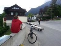
| + | [[File:2014-05-28 47 11 LeslieHapablap 1401296722997.jpg|300px|thumb|left|Waiting for all participants.]] | ||
| + | *Close to Innsbruck again. -- [[User:LeslieHapablap|LeslieHapablap]] ([[User talk:LeslieHapablap|talk]]) 10:07, 27 May 2014 (EDT) | ||
| − | + | We all came by different means of transportation. [[User:1-0|1-0]] was at the meeting point first, he came by bus. [[User:LeslieHapablap|LeslieHapablap]] arrived next by bike, then [[User:EleanorAbernathy|EleanorAbernathy]] who had walked up to Hungerburg. [[User:OwlOnAWheel|OwlOnAWheel]] took the cable car from the city center. From the panorama platform at Hungerburg it was only a short walk to the hashpoint. We came across the same clearance as seen in [[Media:2013-06-08 47 11 23-33-44-039.jpg|this picture]] from an [[2013-06-08 47 11|earlier expedition]]. The two hashpoints are only 160 m apart, which qualifies [[User:LeslieHapablap|LeslieHapablap]] and [[User:EleanorAbernathy|EleanorAbernathy]] for the [[Déjà_Vu_Geohash|Déjà Vu achievement]]. | |
| − | |||
| − | |||
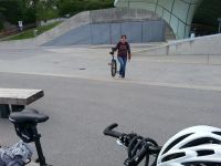
| + | [[File:2014-05-28 47 11 LeslieHapablap 1401298100064.jpg|300px|thumb|right|Downhill trail.]] | ||
| + | The hashpoint itself was both directly beneath the cables of the Hungerburg cable car and on a mountain bike downhill trail, which [[User:1-0|1-0]] often uses. This means today many people have been geohashing unknowingly. [[User:OwlOnAWheel|OwlOnAWheel]] and [[User:1-0|1-0]] had fun on the trail for a little while, then we took the group picture and returned to civilization. [[User:1-0|1-0]] joined in for a geohash dinner at [[User:EleanorAbernathy|EleanorAbernathy]]'s and [[User:LeslieHapablap|LeslieHapablap]]'s place. | ||
| + | {{-}} | ||
== Photos == | == Photos == | ||
<!-- Insert pictures between the gallery tags using the following format: | <!-- Insert pictures between the gallery tags using the following format: | ||
Image:2012-##-## ## ## Alpha.jpg | Witty Comment | Image:2012-##-## ## ## Alpha.jpg | Witty Comment | ||
--> | --> | ||
| − | <gallery perrow="5"> | + | <gallery perrow="5" widths=200px heights=150> |
| + | |||
| + | Image:2014-05-28_47_11_LeslieHapablap_1401294850059.jpg | Weather: slightly overcast but dry. | ||
| + | |||
| + | Image:2014-05-28_47_11_LeslieHapablap_1401308512000.jpg | Almost at Hungerburg. | ||
| + | |||
| + | Image:2014-05-28_47_11_LeslieHapablap_1401296259170.jpg | [[User:1-0|1-0]] already waiting at the panorama platform. | ||
| + | |||
| + | Image:2014-05-28_47_11_LeslieHapablap_1401296487623.jpg | | ||
| + | |||
| + | Image:2014-05-28_47_11_LeslieHapablap_1401296699413.jpg | [[User:EleanorAbernathy|EleanorAbernathy]] arriving by foot. | ||
| + | |||
| + | Image:2014-05-28_47_11_LeslieHapablap_1401296722997.jpg | | ||
| + | |||
| + | Image:2014-05-28_47_11_LeslieHapablap_1401297039059.jpg | [[User:OwlOnAWheel|OwlOnAWheel]] arriving by cable car. | ||
| + | |||
| + | Image:2014-05-28_47_11_LeslieHapablap_1401297970802.jpg | Attention, mountainbike trail. Danger. | ||
| + | |||
| + | Image:2014-05-28_47_11_LeslieHapablap_1401298100064.jpg | The mountain bike trail. | ||
| + | |||
| + | Image:2014-05-28_47_11_LeslieHapablap_1401310875946.jpg | | ||
| + | |||
| + | Image:2014-05-28_47_11_LeslieHapablap_1401310901050.jpg | | ||
| + | |||
| + | Image:2014-05-28_47_11_LeslieHapablap_1401311031417.jpg | | ||
| + | |||
| + | Image:2014-05-28_47_11_LeslieHapablap_1401308998000.jpg | | ||
| + | |||
| + | Image:2014-05-28_47_11_LeslieHapablap_1401298811678.jpg | | ||
| + | |||
| + | Image:2014-05-28_47_11_LeslieHapablap_1401298868217.jpg | | ||
| + | |||
| + | Image:2014-05-28_47_11_LeslieHapablap_1401298946656.jpg | | ||
| + | |||
| + | Image:2014-05-28_47_11_LeslieHapablap_1401299003992.jpg | | ||
| + | |||
| + | Image:2014-05-28_47_11_LeslieHapablap_1401299198285.jpg | | ||
| + | |||
| + | Image:2014-05-28_47_11_LeslieHapablap_1401300271136.jpg | On our way home. | ||
| + | |||
| + | Image:2014-05-28_47_11_LeslieHapablap_1401303133785.jpg | Geohash dinner. | ||
| + | |||
| + | |||
| + | Image:2014-05-28_47_11_LeslieHapablap_1401298609929.jpg | Obligatory proof. | ||
| + | |||
</gallery> | </gallery> | ||
| Line 51: | Line 99: | ||
{{#vardefine:ribbonwidth|800px}} | {{#vardefine:ribbonwidth|800px}} | ||
<!-- Add any achievement ribbons you earned below, or remove this section --> | <!-- Add any achievement ribbons you earned below, or remove this section --> | ||
| + | {{land geohash | ||
| + | |||
| + | | latitude = 47 | ||
| + | | longitude = 11 | ||
| + | | date = 2014-05-28 | ||
| + | | name = All participants | ||
| + | |||
| + | }} | ||
| + | {{bicycle geohash | ||
| + | |||
| + | | latitude = 47 | ||
| + | | longitude = 11 | ||
| + | | date = 2014-05-28 | ||
| + | | name = [[User:LeslieHapablap|LeslieHapablap]] | ||
| + | | bothways = true | ||
| + | |||
| + | }} | ||
| + | {{Walk geohash | ||
| + | |||
| + | | latitude = 47 | ||
| + | | longitude = 11 | ||
| + | | date = 2014-05-28 | ||
| + | | name = [[User:EleanorAbernathy|EleanorAbernathy]] | ||
| + | }} | ||
| + | {{Public transport geohash | ||
| + | |||
| + | | latitude = 47 | ||
| + | | longitude = 11 | ||
| + | | date = 2014-05-28 | ||
| + | | busline = bus J and cable car, respectively | ||
| + | | name = [[User:1-0|1-0]] and [[User:OwlOnAWheel|OwlOnAWheel]] | ||
| + | |||
| + | }} | ||
| + | {{Circus_geohash | ||
| + | |||
| + | | latitude = 47 | ||
| + | | longitude = 11 | ||
| + | | date = 2014-05-28 | ||
| + | | name = [[User:OwlOnAWheel|OwlOnAWheel]] and [[User:1-0|1-0]] | ||
| + | | performance = unicycling | ||
| + | }} | ||
| + | {{Déjà vu geohash | ||
| + | | latitude = 47 | ||
| + | | longitude = 11 | ||
| + | | date = 2014-05-28 | ||
| + | | olddate = [[2013-06-08 47 11|2013-06-08]] | ||
| + | | name = [[User:EleanorAbernathy|EleanorAbernathy]] and [[User:LeslieHapablap|LeslieHapablap]] | ||
| + | | image = 2013-06-08 47 11 23-33-44-039.jpg | ||
| + | }} | ||
<!-- =============== USEFUL CATEGORIES FOLLOW ================ | <!-- =============== USEFUL CATEGORIES FOLLOW ================ | ||
| Line 62: | Line 159: | ||
[[Category:Expedition planning]] | [[Category:Expedition planning]] | ||
--> | --> | ||
| − | [[Category: | + | [[Category:Expeditions]] |
| + | [[Category:Expeditions with photos]] | ||
| + | [[Category:Coordinates reached]] | ||
<!-- An actual expedition: | <!-- An actual expedition: | ||
[[Category:Expeditions]] | [[Category:Expeditions]] | ||
| Line 91: | Line 190: | ||
(Don't forget to delete this final close comment marker) --> | (Don't forget to delete this final close comment marker) --> | ||
| + | {{location|AT|T|I}} | ||
Latest revision as of 06:42, 14 August 2019

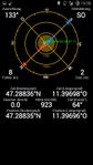
| Wed 28 May 2014 in 47,11: 47.2883587, 11.3969840 geohashing.info google osm bing/os kml crox |
Location
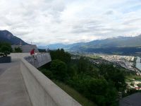
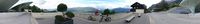
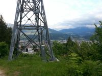
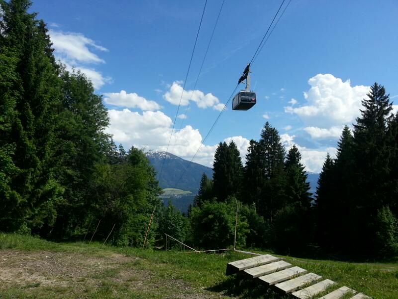
On a mountain bike downhill trail, directly beneath the Hungerburg cable car.
Participants
- EleanorAbernathy
- OwlOnAWheel
- 1-0
- LeslieHapablap (previous|next)
- Waltraud the hashkiwi
Plans
This one is about 160 m away from a previous hashpoint. We will meet at the Hungerburg valley station at 7 p.m. and then go a few hundred meters uphill to the hashpoint.
Expedition

- Close to Innsbruck again. -- LeslieHapablap (talk) 10:07, 27 May 2014 (EDT)
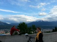
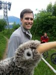
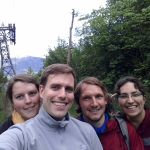
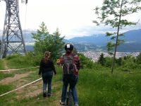
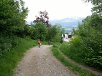
We all came by different means of transportation. 1-0 was at the meeting point first, he came by bus. LeslieHapablap arrived next by bike, then EleanorAbernathy who had walked up to Hungerburg. OwlOnAWheel took the cable car from the city center. From the panorama platform at Hungerburg it was only a short walk to the hashpoint. We came across the same clearance as seen in this picture from an earlier expedition. The two hashpoints are only 160 m apart, which qualifies LeslieHapablap and EleanorAbernathy for the Déjà Vu achievement.

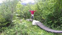
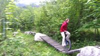
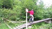
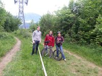
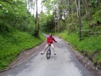
The hashpoint itself was both directly beneath the cables of the Hungerburg cable car and on a mountain bike downhill trail, which 1-0 often uses. This means today many people have been geohashing unknowingly. OwlOnAWheel and 1-0 had fun on the trail for a little while, then we took the group picture and returned to civilization. 1-0 joined in for a geohash dinner at EleanorAbernathy's and LeslieHapablap's place.
Photos
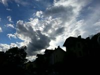
Weather: slightly overcast but dry.
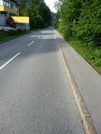
Almost at Hungerburg.
1-0 already waiting at the panorama platform.
EleanorAbernathy arriving by foot.
OwlOnAWheel arriving by cable car.
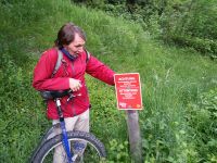
Attention, mountainbike trail. Danger.
The mountain bike trail.
On our way home.
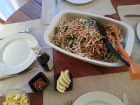
Geohash dinner.
Obligatory proof.


Achievements
All participants earned the Land geohash achievement
|
LeslieHapablap earned the Bicycle geohash achievement
|
EleanorAbernathy earned the Walk geohash Achievement
|
1-0 and OwlOnAWheel earned the Public transport geohash achievement
|
OwlOnAWheel and 1-0 earned the Circus Geohash Achievement
|
EleanorAbernathy and LeslieHapablap earned the Déjà Vu Geohash Achievement
|