Difference between revisions of "2014-05-28 49 8"
imported>DODO (→Photos) |
imported>FippeBot m (Location) |
||
| (4 intermediate revisions by one other user not shown) | |||
| Line 38: | Line 38: | ||
== Tracklog == | == Tracklog == | ||
<!-- if your GPS device keeps a log, you may post a link here --> | <!-- if your GPS device keeps a log, you may post a link here --> | ||
| − | + | [http://www.komoot.de/tour/2891376 4 KM walk (and 4 KM train back home)] | |
== Photos == | == Photos == | ||
| Line 65: | Line 65: | ||
<!-- Add any achievement ribbons you earned below, or remove this section --> | <!-- Add any achievement ribbons you earned below, or remove this section --> | ||
| + | {{land geohash | ||
| − | + | | latitude = 49 | |
| − | + | | longitude = 8 | |
| − | + | | date = 2014-05-28 | |
| + | | name = DODO | ||
| + | }} | ||
| − | + | {{Walk geohash | |
| + | | latitude = 49 | ||
| + | | longitude = 8 | ||
| + | | date = 2014-05-28 | ||
| + | | name = DODO | ||
| + | | distance = 4,6 KM | ||
| + | | image=2014-05-28 49 8-12.jpg | ||
| + | }} | ||
| − | + | The place is named Heiligenstein (holy stone or stone of the saints) and you can see the graveyard from the hashpoint, but I still think, this isn't good enough for a holy hash, is it? | |
| − | |||
| − | |||
| − | |||
| − | |||
[[Category:Expeditions]] | [[Category:Expeditions]] | ||
| − | |||
[[Category:Expeditions with photos]] | [[Category:Expeditions with photos]] | ||
| − | |||
| − | |||
| − | |||
| − | |||
| − | |||
[[Category:Coordinates reached]] | [[Category:Coordinates reached]] | ||
| − | + | {{location|DE|RP|RP}} | |
| − | |||
| − | |||
| − | |||
| − | |||
| − | |||
| − | |||
| − | |||
| − | |||
| − | |||
| − | |||
| − | |||
| − | |||
| − | |||
| − | |||
| − | |||
| − | |||
| − | |||
Latest revision as of 06:42, 14 August 2019
| Wed 28 May 2014 in 49,8: 49.2883587, 8.3969840 geohashing.info google osm bing/os kml crox |
Location
A field near Römerberg-Heiligenstein on the other side of the railway.
Participants
Plans
I expect just another acre to walk in, get some dirty shoes, meet nobody and walk out again, but it is too close to home to not to go. I’ll have some time in the evening and will try to walk there to gain at least a new achievement. Except anyone will be there at another time, I’ll be there after 8 pm. Maybe, I’ll visit the nearby graveyard and ride back by train.
Expedition
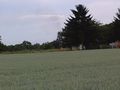
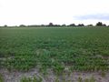
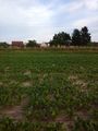
My first opportunity for a walk geohash, just 4 KM from home. I started at quarter past seven when girlfriend went singing. It's funny, how much more things you see when walking, even compared with riding your bike. So I found three bridges, some redcurrants (already red) and some roses. As I expected I found the hash lying 30 m into a field. There were the same plants as on the field the day before yesterday, but they were planted much denser and so I doubt that it is salad. Anyway, I still could walk between them without doing any harm to them and as it is raining in almost complete germany except here the soil was dry and I didn't even get dirty shoes.
When I left the hashpoint it was 20:06 and I remembered that a train goes in Heiligenstein at 20:12. So I hurried to the train station, which I could already see from the hash (I even forgot to take a picture of myself but caught this up when I was back on the path between the field and the railway). I reached the station at 20:13 but found out that I remembered the wrong time. It was 20:19. So I had plenty of time to buy a ticket (1,50€) and even had time to enjoy the little beer, I took with me to celebrate the hash. Only the cemetery has to wait for the next hash in Heiligenstein.
Tracklog
4 KM walk (and 4 KM train back home)
Photos
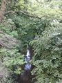
View from the first bridge
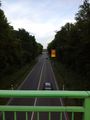
The view from the second and ...
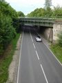
from the third bridge is less romantic
Fire
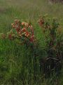
Already red redcurrants

roses
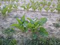
Who knows these plants?
Plenty of them around the hashpoint (30 m away)
a second earlier it was 0m away :-(
View 1
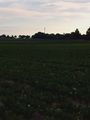
View 2

Successful geohasher
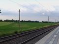
View from the station to the hash. You can see the towers of Speyer in the background

gratification


Achievements
DODO earned the Land geohash achievement
|
DODO earned the Walk geohash Achievement
|
The place is named Heiligenstein (holy stone or stone of the saints) and you can see the graveyard from the hashpoint, but I still think, this isn't good enough for a holy hash, is it?