2014-05-29
From Geohashing
Revision as of 13:38, 28 May 2014 by imported>AperfectBot (Ook.)
Expedition Archives from May 2014
Wednesday 28 May 2014 | Thursday 29 May 2014 | Friday 30 May 2014
See also: Category:Meetup on 2014-05-29
Coordinates
West of -30°: .9658362, .2296825
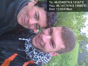
East of -30°: .0348536, .1316679
Globalhash:
-83.726355063903,-132.599547990750
Photo Gallery
Expeditions and Plans
| 2014-05-29 | ||
|---|---|---|
| San Diego, California | LucasBrown | A brush-covered hillside above the Gonzales Canyon on the south side of the... |
| Pforzheim, Germany | RecentlyChanged | In the beautiful Black forest! (Even on a existing path!) |
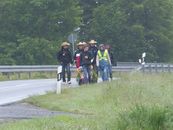
| Cottbus, Germany | Danatar | in a rapeseed field near Langenwolmsdorf, a part of Stolpen. Country: Ger... |
| Utrecht, Netherlands | JwB | A field near A27 highway |