Difference between revisions of "2014-05-30 39 -77"
From Geohashing
imported>OfficeLinebacker ([retro picture] Bit of a macabre find [http://www.openstreetmap.org/?lat=39.11295175&lon=-77.28858062&zoom=16&layers=B000FTF @39.1130,-77.2886]) |
imported>FippeBot m (Location) |
||
| (6 intermediate revisions by 2 users not shown) | |||
| Line 21: | Line 21: | ||
== Participants == | == Participants == | ||
| − | + | [[User:OfficeLinebacker|OfficeLinebacker]] | |
| − | |||
== Plans == | == Plans == | ||
| Line 46: | Line 45: | ||
Image:2014-05-30_39_-77_13-44-50-855.jpg | Bit of a macabre find [http://www.openstreetmap.org/?lat=39.11295175&lon=-77.28858062&zoom=16&layers=B000FTF @39.1130,-77.2886] | Image:2014-05-30_39_-77_13-44-50-855.jpg | Bit of a macabre find [http://www.openstreetmap.org/?lat=39.11295175&lon=-77.28858062&zoom=16&layers=B000FTF @39.1130,-77.2886] | ||
| + | |||
| + | Image:2014-05-30_39_-77_13-45-24-911.jpg | [http://www.openstreetmap.org/?lat=39.11320000&lon=-77.28870000&zoom=16&layers=B000FTF @39.1132,-77.2887] | ||
| + | |||
| + | Image:2014-05-30_39_-77_13-45-43-507.jpg | [http://www.openstreetmap.org/?lat=39.11295408&lon=-77.28858996&zoom=16&layers=B000FTF @39.1130,-77.2886] | ||
| + | |||
| + | Image:2014-05-30_39_-77_13-45-54-412.jpg | [http://www.openstreetmap.org/?lat=39.11280000&lon=-77.28860000&zoom=16&layers=B000FTF @39.1128,-77.2886] | ||
| + | |||
| + | Image:2014-05-30_39_-77_13-46-11-035.jpg | [http://www.openstreetmap.org/?lat=39.11293112&lon=-77.28850443&zoom=16&layers=B000FTF @39.1129,-77.2885] | ||
| + | |||
| + | Image:2014-05-30_39_-77_13-49-11-604.jpg | Last stream to cross [http://www.openstreetmap.org/?lat=39.11370000&lon=-77.28840000&zoom=16&layers=B000FTF @39.1137,-77.2884] | ||
</gallery> | </gallery> | ||
| Line 53: | Line 62: | ||
| − | |||
| − | |||
| − | |||
| − | |||
| − | |||
| − | |||
| − | |||
| − | |||
| − | |||
| − | |||
| − | |||
| − | |||
[[Category:Expeditions]] | [[Category:Expeditions]] | ||
| − | |||
[[Category:Expeditions with photos]] | [[Category:Expeditions with photos]] | ||
| − | |||
| − | |||
| − | |||
| − | |||
| − | |||
[[Category:Coordinates reached]] | [[Category:Coordinates reached]] | ||
| − | + | {{location|US|MD|MO}} | |
| − | |||
| − | |||
| − | |||
| − | |||
| − | |||
| − | |||
| − | |||
| − | |||
| − | |||
| − | |||
| − | |||
| − | |||
| − | |||
| − | |||
| − | |||
| − | |||
| − | |||
Latest revision as of 06:44, 14 August 2019
| Fri 30 May 2014 in 39,-77: 39.1125475, -77.2881914 geohashing.info google osm bing/os kml crox |
Location
Participants
Plans
Expedition
- Embarking on this one. -- OfficeLinebacker (talk) @39.1298,-77.2702 12:30, 31 May 2014 (EDT)
Tracklog
Photos

Right at the fence line @39.1126,-77.2882
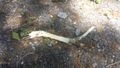
Bit of a macabre find @39.1130,-77.2886
Last stream to cross @39.1137,-77.2884


