Difference between revisions of "2014-06-05 51 10"
imported>GeorgDerReisende (new expedition) |
imported>GeorgDerReisende (expedition report added) |
||
| Line 1: | Line 1: | ||
| − | |||
| − | |||
| − | |||
| − | |||
| − | |||
| − | |||
| − | |||
| − | |||
| − | |||
| − | |||
{{meetup graticule | {{meetup graticule | ||
| lat=51 | | lat=51 | ||
| Line 18: | Line 8: | ||
__NOTOC__ | __NOTOC__ | ||
== Location == | == Location == | ||
| − | + | ||
| + | The hash lied at the edge of a field near Nüxei. | ||
== Participants == | == Participants == | ||
| − | + | ||
| − | + | [[User:GeorgDerReisende|GeorgDerReisende]] | |
== Plans == | == Plans == | ||
| − | + | ||
| + | To hitchhike from Kassel to Nüxei, afterwards looking for some geocaches. | ||
== Expedition == | == Expedition == | ||
| − | + | ||
| + | I started at home at 9:00, started to hitchhike at 10:00 and arrived at the Göttingen junction of the A7 motorway at 10:30. Through Göttingen I took the bus. Then at the eastern end of Göttingen I started to hitchhike at 11:32 and with lifts to Gieboldehausen, Barbis and to the Bad Sachsa junction I arrived at 14:34. I found me opposite a new road, 984 meters away from the hash. | ||
| + | |||
| + | At first I tried to walk on the new road, but the asphalt was too hot, which would have destroyed my sandals. Then I walked along the national road to the hash. I found it near the road, about nine meters from the road and five meters away from the field's border. | ||
| + | |||
| + | Afterwards I walked to Nüxei, looked for a geocache, found it, looked for other geocaches, and didn't find them, then I walked to the main road to hitchhike home. I started there to hitchhike at 16:40, and with three cars, two buses and a tram I arrived at home at 19:32. | ||
== Tracklog == | == Tracklog == | ||
| Line 38: | Line 35: | ||
--> | --> | ||
<gallery perrow="5"> | <gallery perrow="5"> | ||
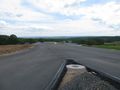
| + | Image:2014-06-05 51 10 GeorgDerReisende 1620.jpg | the new road | ||
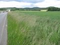
| + | Image:2014-06-05 51 10 GeorgDerReisende 1624.jpg | the site of the hash | ||
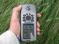
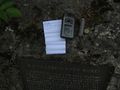
| + | Image:2014-06-05 51 10 GeorgDerReisende 1625.jpg | proof | ||
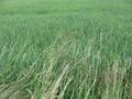
| + | Image:2014-06-05 51 10 GeorgDerReisende 1626.jpg | five meters in the field | ||
| + | Image:2014-06-05 51 10 GeorgDerReisende 1629.jpg | view to the west | ||
| + | Image:2014-06-05 51 10 GeorgDerReisende 1630.jpg | view to the east | ||
| + | Image:2014-06-05 51 10 GeorgDerReisende 1632.jpg | view to the south | ||
| + | Image:2014-06-05 51 10 GeorgDerReisende 1635.jpg | one of five houses of Nüxei | ||
| + | Image:2014-06-05 51 10 GeorgDerReisende 1654.jpg | geocache | ||
| + | Image:2014-06-05 51 10 GeorgDerReisende 1706.jpg | the geohasher | ||
</gallery> | </gallery> | ||
| Line 44: | Line 51: | ||
<!-- Add any achievement ribbons you earned below, or remove this section --> | <!-- Add any achievement ribbons you earned below, or remove this section --> | ||
| + | {{Thumbs Up | latitude = 51 | longitude = 10 | date = 2014-06-05 | name = GeorgDerReisende }} | ||
| − | + | {{Hash collision | latitude = 51 | longitude = 10 | date = 2014-06-05 | name = GeorgDerReisende | link = http://coord.info/GC3EAQ9 | id = GC3EAQ9 | distance = 0.74 km | honor = yes }} | |
| − | |||
| − | |||
| − | + | [[Category:Expeditions]] | |
| − | + | [[Category:Expeditions with photos]] | |
| − | |||
| − | [[Category: | ||
| − | |||
| − | |||
| − | |||
| − | |||
| − | |||
| − | |||
| − | |||
| − | |||
| − | |||
| − | |||
[[Category:Coordinates reached]] | [[Category:Coordinates reached]] | ||
| − | |||
| − | |||
| − | |||
| − | |||
| − | |||
| − | |||
| − | |||
| − | |||
| − | |||
| − | |||
| − | |||
| − | |||
| − | |||
| − | |||
| − | |||
| − | |||
| − | |||
| − | |||
Revision as of 18:54, 5 June 2014
| Thu 5 Jun 2014 in 51,10: 51.5745691, 10.5168972 geohashing.info google osm bing/os kml crox |
Location
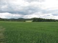
The hash lied at the edge of a field near Nüxei.
Participants
Plans
To hitchhike from Kassel to Nüxei, afterwards looking for some geocaches.
Expedition
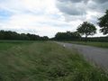
I started at home at 9:00, started to hitchhike at 10:00 and arrived at the Göttingen junction of the A7 motorway at 10:30. Through Göttingen I took the bus. Then at the eastern end of Göttingen I started to hitchhike at 11:32 and with lifts to Gieboldehausen, Barbis and to the Bad Sachsa junction I arrived at 14:34. I found me opposite a new road, 984 meters away from the hash.
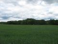
At first I tried to walk on the new road, but the asphalt was too hot, which would have destroyed my sandals. Then I walked along the national road to the hash. I found it near the road, about nine meters from the road and five meters away from the field's border.
Afterwards I walked to Nüxei, looked for a geocache, found it, looked for other geocaches, and didn't find them, then I walked to the main road to hitchhike home. I started there to hitchhike at 16:40, and with three cars, two buses and a tram I arrived at home at 19:32.
Tracklog
Photos
the new road
the site of the hash
proof
five meters in the field
view to the west
view to the east
view to the south
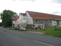
one of five houses of Nüxei
geocache
the geohasher


Achievements
GeorgDerReisende earned the Thumbs Up Geohash Achievement
|
GeorgDerReisende earned the Hash collision honorable mention
|