Difference between revisions of "2014-06-07 53 8"
imported>Oliver (Created page with "{{subst:Expedition |lat = 53 |lon = 8 |date = 2014-06-07 }}") |
imported>FippeBot m (Location) |
||
| (3 intermediate revisions by one other user not shown) | |||
| Line 18: | Line 18: | ||
__NOTOC__ | __NOTOC__ | ||
== Location == | == Location == | ||
| − | + | This Saturday hash is at the side of a field north of Bremen, between Schwanewede and Osterholz-Scharmbeck. | |
== Participants == | == Participants == | ||
<!-- who attended: If you link to your wiki user name in this section, your expedition will be picked up by the various statistics generated for geohashing. You may use three tildes ~ as a shortcut to automatically insert the user signature of the account you are editing with. | <!-- who attended: If you link to your wiki user name in this section, your expedition will be picked up by the various statistics generated for geohashing. You may use three tildes ~ as a shortcut to automatically insert the user signature of the account you are editing with. | ||
--> | --> | ||
| + | * [[User:Oliver|Oliver]] | ||
== Plans == | == Plans == | ||
<!-- what were the original plans --> | <!-- what were the original plans --> | ||
| + | It's about 30km by bike for me, and the weather is great, so should be doable. Will try to be there at 16:00. [[User:Oliver|Oliver]] ([[User talk:Oliver|talk]]) | ||
== Expedition == | == Expedition == | ||
| − | + | Left home a bit later than intended, but with great weather and little wind cycling was pretty easy. Went through Walle and Gröpelingen on a quite common cycling track, then switched to a route suggested by [http://www.yournavigation.org/ yournavigation.org] which went through the northern outskirts of Bremen und finally into the wild (though there were suprisingly many benches set up along the ways - I have no idea who actually goes and uses them out there). | |
| + | |||
| + | Reached the field at about 16:05 and discovered that full-length trousers would have been a good idea: lots of nettles and thistles were growing on the side of the field and were somewhat painful when wearing shorts only. Together with some barbed wire at the far end of the field, the hashdance became quite tedious; also, the trees probably worsened GPS reception, causing me to climb the barbed wire fence ''twice''. Finally located the hashpoint with GPS and map in a pretty nice planting of trees. | ||
| + | |||
| + | To get back to the road I decided to go between the trees rather than encounter the nettles again, but that way turned out to have lots of brambles as well. But at long last I finally reached the bike again and cycled off, this time going along B6 route for a change. With the sun still burning hot I made a stop on the way to get some sweets and water, and so the way home took a bit longer; but in end I got back well and found it a very enjoyable tour. | ||
| − | |||
| − | |||
== Photos == | == Photos == | ||
| Line 38: | Line 42: | ||
--> | --> | ||
<gallery perrow="5"> | <gallery perrow="5"> | ||
| + | Image:2014-06-07-bremen-53-8-oliver-1.jpg | On the way, just outside of Bremen | ||
| + | Image:2014-06-07-bremen-53-8-oliver-2.jpg | GPS has finally stopped jumping around | ||
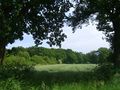
| + | Image:2014-06-07-bremen-53-8-oliver-3.jpg | View from the hashpoint | ||
| + | Image:2014-06-07-bremen-53-8-oliver-4.jpg | Finally escaped from the brambles! | ||
| + | Image:2014-06-07-bremen-53-8-oliver-5.jpg | Looking back at the hashpoint (which should be near the white bush in the distance) | ||
</gallery> | </gallery> | ||
| Line 44: | Line 53: | ||
<!-- Add any achievement ribbons you earned below, or remove this section --> | <!-- Add any achievement ribbons you earned below, or remove this section --> | ||
| + | {{bicycle geohash | ||
| + | | latitude = 53 | ||
| + | | longitude = 8 | ||
| + | | date = 2014-06-07 | ||
| + | | name = [[User:Oliver|Oliver]] | ||
| + | | bothways = true | ||
| + | | image = 2014-06-07-bremen-53-8-oliver-4.jpg | ||
| + | }} | ||
| − | |||
| − | |||
| − | |||
| − | |||
| − | |||
| − | |||
| − | |||
| − | |||
| − | |||
| − | |||
| − | |||
| − | |||
[[Category:Expeditions]] | [[Category:Expeditions]] | ||
| − | |||
[[Category:Expeditions with photos]] | [[Category:Expeditions with photos]] | ||
| − | |||
| − | |||
| − | |||
| − | |||
| − | |||
[[Category:Coordinates reached]] | [[Category:Coordinates reached]] | ||
| − | + | {{location|DE|NI|OHZ}} | |
| − | |||
| − | |||
| − | |||
| − | |||
| − | |||
| − | |||
| − | |||
| − | |||
| − | |||
| − | |||
| − | |||
| − | |||
| − | |||
| − | |||
| − | |||
| − | |||
| − | |||
Latest revision as of 06:49, 14 August 2019
| Sat 7 Jun 2014 in 53,8: 53.2163560, 8.6759570 geohashing.info google osm bing/os kml crox |
Location
This Saturday hash is at the side of a field north of Bremen, between Schwanewede and Osterholz-Scharmbeck.
Participants
Plans
It's about 30km by bike for me, and the weather is great, so should be doable. Will try to be there at 16:00. Oliver (talk)
Expedition
Left home a bit later than intended, but with great weather and little wind cycling was pretty easy. Went through Walle and Gröpelingen on a quite common cycling track, then switched to a route suggested by yournavigation.org which went through the northern outskirts of Bremen und finally into the wild (though there were suprisingly many benches set up along the ways - I have no idea who actually goes and uses them out there).
Reached the field at about 16:05 and discovered that full-length trousers would have been a good idea: lots of nettles and thistles were growing on the side of the field and were somewhat painful when wearing shorts only. Together with some barbed wire at the far end of the field, the hashdance became quite tedious; also, the trees probably worsened GPS reception, causing me to climb the barbed wire fence twice. Finally located the hashpoint with GPS and map in a pretty nice planting of trees.
To get back to the road I decided to go between the trees rather than encounter the nettles again, but that way turned out to have lots of brambles as well. But at long last I finally reached the bike again and cycled off, this time going along B6 route for a change. With the sun still burning hot I made a stop on the way to get some sweets and water, and so the way home took a bit longer; but in end I got back well and found it a very enjoyable tour.
Photos
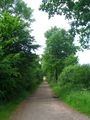
On the way, just outside of Bremen
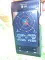
GPS has finally stopped jumping around
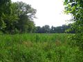
View from the hashpoint
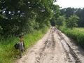
Finally escaped from the brambles!
Looking back at the hashpoint (which should be near the white bush in the distance)


Achievements
Oliver earned the Bicycle geohash achievement
|